West Alexandria, Ohio
West Alexandria is a village in Preble County, Ohio, United States. The population was 1,340 at the 2010 census.
West Alexandria, Ohio | |
|---|---|
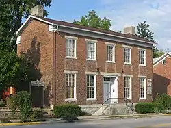 The George B. Unger House, a historic site in the village | |
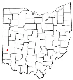 Location of West Alexandria, Ohio | |
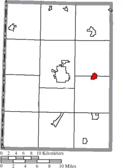 Location of West Alexandria in Preble County | |
| Coordinates: 39°44′40″N 84°32′1″W | |
| Country | United States |
| State | Ohio |
| County | Preble |
| Government | |
| • Mayor | Jeff Hickey |
| Area | |
| • Total | 0.86 sq mi (2.24 km2) |
| • Land | 0.86 sq mi (2.24 km2) |
| • Water | 0.00 sq mi (0.00 km2) |
| Population | |
| • Total | 1,340 |
| • Estimate (2019)[3] | 1,325 |
| • Density | 1,535.34/sq mi (592.70/km2) |
| Time zone | UTC-5 (Eastern (EST)) |
| • Summer (DST) | UTC-4 (EDT) |
| ZIP code | 45381 |
| Area code(s) | 937, 326 |
| FIPS code | 39-82880 |
| Website | http://www.walexpreb.org/ |
History
West Alexandria was laid out in 1818.[4] The community derives its name from one of its founders, William Alexander.[5] A post office has been in operation at West Alexandria since 1828.[6]
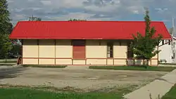
Three buildings in the village have been listed on the National Register of Historic Places: the George B. Unger House, the Lange Hotel, and the West Alexandria Depot.[7]
Geography
West Alexandria is located at 39°44′40″N 84°32′1″W (39.744544, -84.533747).[8]
According to the United States Census Bureau, the village has a total area of 0.67 square miles (1.74 km2), all land.[9]
Demographics
| Historical population | |||
|---|---|---|---|
| Census | Pop. | %± | |
| 1870 | 455 | — | |
| 1880 | 796 | 74.9% | |
| 1890 | 575 | −27.8% | |
| 1900 | 740 | 28.7% | |
| 1910 | 1,080 | 45.9% | |
| 1920 | 994 | −8.0% | |
| 1930 | 924 | −7.0% | |
| 1940 | 993 | 7.5% | |
| 1950 | 1,183 | 19.1% | |
| 1960 | 1,524 | 28.8% | |
| 1970 | 1,553 | 1.9% | |
| 1980 | 1,313 | −15.5% | |
| 1990 | 1,460 | 11.2% | |
| 2000 | 1,395 | −4.5% | |
| 2010 | 1,340 | −3.9% | |
| 2019 (est.) | 1,325 | [3] | −1.1% |
| U.S. Decennial Census[10] | |||
2010 census
As of the census[2] of 2010, there were 1,340 people, 551 households, and 371 families living in the village. The population density was 2,000.0 inhabitants per square mile (772.2/km2). There were 611 housing units at an average density of 911.9 per square mile (352.1/km2). The racial makeup of the village was 96.4% White, 1.0% African American, 0.1% Native American, 0.6% Asian, 0.1% from other races, and 1.8% from two or more races. Hispanic or Latino of any race were 1.4% of the population.
There were 551 households, of which 35.0% had children under the age of 18 living with them, 46.5% were married couples living together, 16.5% had a female householder with no husband present, 4.4% had a male householder with no wife present, and 32.7% were non-families. 28.9% of all households were made up of individuals, and 12% had someone living alone who was 65 years of age or older. The average household size was 2.43 and the average family size was 2.96.
The median age in the village was 37.8 years. 25.4% of residents were under the age of 18; 8.9% were between the ages of 18 and 24; 25.8% were from 25 to 44; 25.1% were from 45 to 64; and 14.8% were 65 years of age or older. The gender makeup of the village was 47.7% male and 52.3% female.
2000 census
As of the census[11] of 2000, there were 1,395 people, 576 households, and 387 families living in the village. The population density was 1,929.0 people per square mile (748.1/km2). There were 600 housing units at an average density of 829.7 per square mile (321.8/km2). The racial makeup of the village was 99.07% White, 0.36% African American, 0.14% Native American, 0.14% from other races, and 0.29% from two or more races. Hispanic or Latino of any race were 0.57% of the population.
There were 576 households, out of which 32.3% had children under the age of 18 living with them, 52.1% were married couples living together, 10.6% had a female householder with no husband present, and 32.8% were non-families. 29.7% of all households were made up of individuals, and 13.5% had someone living alone who was 65 years of age or older. The average household size was 2.42 and the average family size was 3.03.
In the village, the population was spread out, with 25.9% under the age of 18, 8.3% from 18 to 24, 30.0% from 25 to 44, 20.4% from 45 to 64, and 15.3% who were 65 years of age or older. The median age was 36 years. For every 100 females there were 98.4 males. For every 100 females age 18 and over, there were 94.0 males.
The median income for a household in the village was $36,399, and the median income for a family was $41,685. Males had a median income of $30,982 versus $24,265 for females. The per capita income for the village was $17,628. About 5.4% of families and 7.4% of the population were below the poverty line, including 9.3% of those under age 18 and 8.8% of those age 65 or over.
Schools
Twin Valley Community Schools operates one elementary school, one middle school, and Twin Valley South High School.[12]
West Alexandria has a public library, a branch of the Preble County District Library.[13]
Arts and culture
The village is home to several traditional events held annually, which includes the Oktoberfest. Held at Peace Park on US 35, music, food and crafts are always main attractions at the event, which opens with classic German music performed from inside the gazebo at the park. Also drawing a large crowd are the country cloggers and two-steppers. These local groups entertain the crowd on an outdoor stage as contemporary country music and classics are played while dancers perform. The second day of the festival always brings out antique car lovers as the Antique Car Run begins its trek through the county on Sunday afternoon. Car lovers can also enjoy other classic vehicles on Saturday as cars throughout the area are lined up along the back of the park for spectators to enjoy.
Another favorite is the Santa's Villa, located on East Dayton Street. Santa's Villa is opened early in December and visitors can enjoy the sights and sounds of Christmas near the village's Peace Park.
Notable person
- Brittanie Cecil - middle school student and athlete who was killed by errant puck at a Columbus Blue Jackets game.
See also
- Heaven's Corner - A Zoo and Animal Sanctuary that used to be located in West Alexandria
References
- "2019 U.S. Gazetteer Files". United States Census Bureau. Retrieved July 28, 2020.
- "U.S. Census website". United States Census Bureau. Retrieved 2013-01-06.
- "Population and Housing Unit Estimates". United States Census Bureau. May 24, 2020. Retrieved May 27, 2020.
- Lowry, Robert Eaton (1915). History of Preble County, Ohio: Her People, Industries and Institutions. B.F. Bowen. p. 162.
- Overman, William Daniel (1958). Ohio Town Names. Akron, OH: Atlantic Press. p. 140.
- "Preble County". Jim Forte Postal History. Retrieved 18 December 2015.
- "National Register Information System". National Register of Historic Places. National Park Service. July 9, 2010.
- "US Gazetteer files: 2010, 2000, and 1990". United States Census Bureau. 2011-02-12. Retrieved 2011-04-23.
- "US Gazetteer files 2010". United States Census Bureau. Retrieved 2013-01-06.
- "Census of Population and Housing". Census.gov. Retrieved June 4, 2015.
- "U.S. Census website". United States Census Bureau. Retrieved 2008-01-31.
- "Homepage". Twin Valley Community Schools. Retrieved 3 March 2018.
- "Locations". Preble County District Library. Retrieved 3 March 2018.
External links
Municipalities and communities of Preble County, Ohio, United States | ||
|---|---|---|
| City | 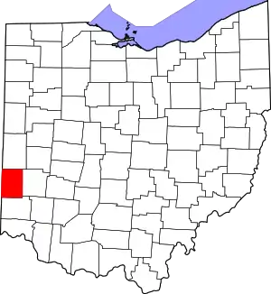 Map of Ohio highlighting Preble County | |
| Villages | ||
| Townships | ||
| CDP | ||
| Unincorporated communities | ||
| Ghost towns | ||
| Footnotes | ‡This populated place also has portions in an adjacent county or counties | |
| ||
| Authority control |
|
|---|