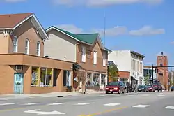
West Jefferson, Ohio
West Jefferson is a village in Madison County, Ohio, United States. The population was 4,222 at the 2010 census. Located along U.S. Route 40, the village has a fairly close relationship with the surrounding township, which include various out-of-corporation-limit neighborhoods (including Haymarket Road, Olmstead Road, Forrest Lake Estates, Goodson Road/Enchanted Valley, and North and South Road). The village has a "Commerce Park" at its western edge which include Target and Amazon Distribution Centers, a Krazy Glue factory, and Jefferson Industries.
West Jefferson, Ohio | |
|---|---|
 | |
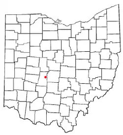 Location of West Jefferson, Ohio | |
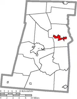 Location of West Jefferson in Madison County | |
| Coordinates: 39°56′36″N 83°16′33″W | |
| Country | United States |
| State | Ohio |
| County | Madison |
| Government | |
| • Mayor | Ray A Martin |
| Area | |
| • Total | 8.15 sq mi (21.11 km2) |
| • Land | 8.13 sq mi (21.05 km2) |
| • Water | 0.02 sq mi (0.06 km2) |
| Population | |
| • Total | 4,222 |
| • Estimate (2019)[3] | 4,431 |
| • Density | 545.15/sq mi (210.48/km2) |
| Time zone | UTC-5 (Eastern (EST)) |
| • Summer (DST) | UTC-4 (EDT) |
| ZIP code | 43162 |
| Area code(s) | 614 and 380 |
| FIPS code | 39-83580 |
| Website | www |
History
West Jefferson was originally called New Hampton, and under the latter name was platted c. 1831.[4] A post office called West Jefferson has been in operation since 1833.[5]
Geography
West Jefferson is located at 39°56′36″N 83°16′33″W (39.943244, −83.275855).[6]
According to the United States Census Bureau, the village has a total area of 4.87 square miles (12.61 km2), of which 4.85 square miles (12.56 km2) is land and 0.02 square miles (0.05 km2) is water.[7]
Demographics
| Historical population | |||
|---|---|---|---|
| Census | Pop. | %± | |
| 1850 | 436 | — | |
| 1860 | 460 | 5.5% | |
| 1880 | 720 | — | |
| 1890 | 778 | 8.1% | |
| 1900 | 803 | 3.2% | |
| 1910 | 1,043 | 29.9% | |
| 1920 | 1,170 | 12.2% | |
| 1930 | 1,376 | 17.6% | |
| 1940 | 1,386 | 0.7% | |
| 1950 | 1,647 | 18.8% | |
| 1960 | 2,774 | 68.4% | |
| 1970 | 3,664 | 32.1% | |
| 1980 | 4,448 | 21.4% | |
| 1990 | 4,505 | 1.3% | |
| 2000 | 4,331 | −3.9% | |
| 2010 | 4,222 | −2.5% | |
| 2019 (est.) | 4,431 | [3] | 5.0% |
| U.S. Decennial Census[8] | |||
2010 census
As of the census[2] of 2010, there were 4,222 people, 1,617 households, and 1,149 families residing in the village. The population density was 870.5 inhabitants per square mile (336.1/km2). There were 1,709 housing units at an average density of 352.4 per square mile (136.1/km2). The racial makeup of the village was 97.6% White, 0.5% African American, 0.3% Asian, 0.2% from other races, and 1.4% from two or more races. Hispanic or Latino of any race were 0.9% of the population.
There were 1,617 households, of which 35.4% had children under the age of 18 living with them, 51.3% were married couples living together, 13.7% had a female householder with no husband present, 6.1% had a male householder with no wife present, and 28.9% were non-families. 25.7% of all households were made up of individuals, and 11.4% had someone living alone who was 65 years of age or older. The average household size was 2.55 and the average family size was 3.02.
The median age in the village was 38.5 years. 25.5% of residents were under the age of 18; 7.9% were between the ages of 18 and 24; 25.4% were from 25 to 44; 25.6% were from 45 to 64; and 15.6% were 65 years of age or older. The gender makeup of the village was 48.9% male and 51.1% female.
2000 census
As of the census[9] of 2000, there were 4,331 people, 1,631 households, and 1,180 families residing in the village. The population density was 1,306.0 people per square mile (503.7/km2). There were 1,704 housing units at an average density of 513.8 per square mile (198.2/km2). The racial makeup of the village was 99.01% White, 0.02% African American, 0.16% Native American, 0.14% Asian, 0.02% Pacific Islander, 0.09% from other races, and 0.55% from two or more races. Hispanic or Latino of any race were 0.58% of the population.
There were 1,631 households, out of which 36.7% had children under the age of 18 living with them, 56.5% were married couples living together, 11.1% had a female householder with no husband present, and 27.6% were non-families. 22.6% of all households were made up of individuals, and 9.6% had someone living alone who was 65 years of age or older. The average household size was 2.60 and the average family size was 3.07.
In the village, the population was spread out, with 27.4% under the age of 18, 7.9% from 18 to 24, 29.5% from 25 to 44, 21.9% from 45 to 64, and 13.4% who were 65 years of age or older. The median age was 35 years. For every 100 females there were 95.4 males. For every 100 females age 18 and over, there were 90.7 males.
The median income for a household in the village was $41,949, and the median income for a family was $50,046. Males had a median income of $36,073 versus $26,734 for females. The per capita income for the village was $20,425. About 6.1% of families and 5.9% of the population were below the poverty line, including 7.6% of those under age 18 and 6.5% of those age 65 or over.
Library
West Jefferson is served by the Hurt/Battelle Memorial Library. In 2005, the library loaned more than 81,000 items to its 9,500 cardholders. Total holdings are over 57,000 volumes with over 60 periodical subscriptions. The Library also has a large collection of VHS tapes.[10]
Education
Norwood Elementary
Norwood Elementary is located in West Jefferson, Ohio, which is about ten miles west of Columbus. Annual enrollment is just over 600 students.
There are 37 certified teachers, 10 support staff, and one administrator at Norwood Elementary.
History
The original Norwood Elementary opened in 1968 and was a K–5 building housing about 300 students. In 1996, the building changed to serve pre-K to 2nd grades. A new facility opened in the fall of 2006 as the only pre-K–grade-5 building in the district. The present building has three sections of pre-K and four sections each of grades K–5. The new facility provides for a separate cafetorium, gym, and large media center.
Co-curricular activities
Norwood Elementary itself does not participate in sports, but the WJYAA (West Jefferson Youth Athletics Association), a non-profit volunteer organization, offers sports such as: baseball, softball, boys' and girls' basketball, cheerleading, dodgeball, football, lacrosse, soccer, and volleyball.
Fifth graders also have the opportunity to participate in the Madison County Math Bee and the Madison County Spelling Bee as well as Student Council.
West Jefferson Middle School
Jefferson Middle School is located 15 miles west of Columbus in the village of West Jefferson. The middle school serves grades 6–8 with an average enrollment of 100 students per grade level. Students receive a comprehensive education which includes the core subjects as well as courses in art, computer, choir, 6th, 7th, and 8th grade band, general music, and consumer education.
Memorial Middle School has 26 certified educators, 4 support staff, and one administrator.
History
The middle school used to be located at 177 S. Frey Ave. and was a combination of the original high school building which was built in 1911 and an addition that was built in 1952. The current Middle School is located at 2 Roughrider Dr and is part of the HS/MS Complex.
Activities
The Middle School also has many extra-curricular activities for grades 7 and 8 including baseball, boys' basketball, cheerleading, football, girls' basketball, co-ed soccer, softball, track and field, girls' volleyball, and wrestling.
Students also have the opportunity to participate in co-curricular activities. Students in grades 6, 7, and 8 participate in both the Madison County Spelling Bee and the Madison County Math Contest. 7th and 8th grade students have the opportunity to participate in student council.
Highlights of the middle school experience
Seventh-graders experience an interdisciplinary approach to the curriculum coordinated by an experienced and collaborative staff. This interdisciplinary approach enables the students to go on many local field trips to which greatly their educational experience.
The highlight of the 8th grade comes at the end of the year with a 4-day 3-night trip to Washington D.C. Students visit many of the sites studied throughout the year.
West Jefferson High School
West Jefferson High School is located in West Central Ohio in the village of West Jefferson. WJHS is a college preparatory high school. WJHS serves students in grades 9–12. Annual enrollment is approximately 400 students.
There are 24 certified teachers, 8 support staff and 2 administrators at West Jefferson High School.
History
The present High School located at 1 Roughrider Drive, was completed in 1969 and the first graduating class of 78 students was in 1970. The High School was completely renovated and an addition was added on in 2005 to make the High School and Middle School one complete building.
Activities
The school offers a full array of extra –curricular activities including athletics, band, choir and drama. The school colors are brown and gold and the mascot is the Roughrider.
West Jefferson High School recognizes its co-curricular program as an important component of the total educational experience of its students. A large percent of WJHS student population participates in the co-curricular program, which offers opportunities in 14 varsity inter-scholastic sports: boys' soccer, cheerleading, football girls' soccer, golf, volleyball in the fall, boys' basketball, girls' basketball, and wrestling in the winter, and then baseball, softball, tennis, and track-and-field in the spring. There is also have bands and choirs. They have a high school concert band that consists of woodwinds, brass, and percussion, a high school marching band that performs at Friday night football games, a pep band that performs during halftime at home basketball games and a jazz band. In the case of chorus, they have a high school concert choir and a chamber choir. Two publications are produced: the Riders Times newspaper and the yearbook.
References
- "2019 U.S. Gazetteer Files". United States Census Bureau. Retrieved July 28, 2020.
- "U.S. Census website". United States Census Bureau. Retrieved 2013-01-06.
- "Population and Housing Unit Estimates". Retrieved May 21, 2020.
- Overman, William Daniel (1958). Ohio Town Names. Akron, OH: Atlantic Press. p. 142.
- "Post offices". Jim Forte Postal History. Retrieved 21 June 2016.
- "US Gazetteer files: 2010, 2000, and 1990". United States Census Bureau. 2011-02-12. Retrieved 2011-04-23.
- "US Gazetteer files 2010". United States Census Bureau. Archived from the original on 2012-01-24. Retrieved 2013-01-06.
- "Census of Population and Housing". Census.gov. Retrieved June 4, 2015.
- "U.S. Census website". United States Census Bureau. Retrieved 2008-01-31.
- "2005 Ohio Public Library Statistics:Statistics by County and Town". State Library of Ohio. Archived from the original on 2006-09-24. Retrieved 2006-11-06.
External links
Municipalities and communities of Madison County, Ohio, United States | ||
|---|---|---|
| City |  Map of Ohio highlighting Madison County | |
| Villages | ||
| Townships | ||
| CDPs | ||
| Unincorporated communities | ||
| Footnotes | ‡This populated place also has portions in an adjacent county or counties | |
| ||