West Melbourne, Victoria
West Melbourne is an inner suburb of Melbourne, Australia, 3 km north-west of and adjacent to Melbourne's Central Business District. Its local government area is the City of Melbourne. At the 2016 census, West Melbourne had a population of 5,515.[1]
| West Melbourne Melbourne, Victoria | |||||||||||||||
|---|---|---|---|---|---|---|---|---|---|---|---|---|---|---|---|
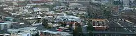 Aerial view of eastern commercial and residential section of West Melbourne looking south toward Melbourne CBD and Docklands. North Melbourne railway station and railyards are at right | |||||||||||||||
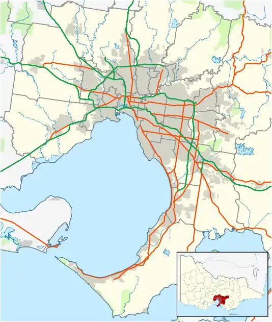 West Melbourne Location in metropolitan Melbourne | |||||||||||||||
| Coordinates | 37.808°S 144.927°E | ||||||||||||||
| Population | 5,515 (2016 census)[1] | ||||||||||||||
| • Density | 862/km2 (2,232/sq mi) | ||||||||||||||
| Postcode(s) | 3003 | ||||||||||||||
| Area | 6.4 km2 (2.5 sq mi) | ||||||||||||||
| Location | 3 km (2 mi) from Melbourne | ||||||||||||||
| LGA(s) | City of Melbourne | ||||||||||||||
| State electorate(s) | Melbourne | ||||||||||||||
| Federal Division(s) | Melbourne | ||||||||||||||
| |||||||||||||||
West Melbourne is bounded by Victoria Street and the Sunbury/Werribee railway lines in the north, Footscray Road, the Moonee Ponds Creek; and by La Trobe Street in the south. Peel Street and the Flagstaff Gardens help form the eastern boundary, with the western boundary defined by the Maribyrnong River and Coode Island, a locality of West Melbourne, which is home to Victoria's largest toxic chemical storage facility.
Being originally largely an industrial area, a significant portion of West Melbourne is occupied by the Port of Melbourne, the Dynon Railway Yards and the Melbourne Markets. These include the Wholesale Fruit and Vegetable and Fish Markets, as well as the National Flower Centre. It also contains an increasing number of residential and commercial properties, consisting of a mixture of Victorian single and double storey terrace houses and converted warehouses at the north-west corner of the Melbourne CBD. It is also adjacent to the Queen Victoria Market, located on the east of Peel Street and to the south of Victoria Street.
History
West Melbourne Post Office opened on 1 March 1937 and was replaced by the Queen Vic Market Newsagency office in 1990, which closed in 1996.[2]
Population
In the 2016 Census, there were 5,515 people in West Melbourne. 42.3% of people were born in Australia. The most common countries of birth were China 7.4%, India 4.9%, South Korea 4.5%, Malaysia 3.7% and New Zealand 2.6%. 45.4% of people only spoke English at home. Other languages spoken at home included Mandarin 10.0%, Korean 4.3%, Cantonese 3.5% and Spanish 2.0%. The most common response for religion was No Religion at 44.8%.[1]
Transport
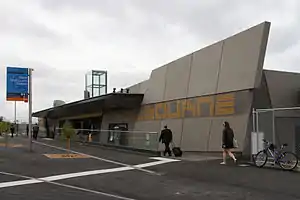
The North Melbourne railway station is actually located in West Melbourne, opposite the Railway Hotel on Ireland Street.
- 401 North Melbourne – University of Melbourne via Royal Melbourne Hospital, University of Melbourne (Monday to Friday). Operated by Transit Systems Victoria.
The 220 bus between Sunshine and Gardenvale passes along Dudley St.
A number of tram routes run along the periphery of the suburb, along Victoria Street (the No.57 West Maribyrnong - Flinders St), Peel/William Street (the No.58 Toorak - West Coburg) and La Trobe Street (the No. 35 City Circle and the no. 30 St Vincent's Plaza - Docklands lines).
Culture
Churches
- West Melbourne Baptist
- St Mary Star of the Sea Catholic
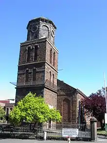
- St James Old Cathedral (Melbourne's oldest cathedral, built in 1842)
- St Mary's Anglican
Hotels
- Carron Tavern, Spencer Street
- McMahons Hotel (Moomba Hotel, formerly North West Hotel), Spencer Street
- Railway Hotel, Ireland Street
- Royal Mail Hotel (formerly Maitz), Spencer Street
- Royal Standard Hotel, William Street
- Hotel Spencer, Spencer Street
- Three Crowns Hotel, Victoria Street
Restaurants

- Sassy.x Restaurant & Bar
- Sarim's Cafe'
- Citrus Mint
- Kathmandu Cottage
- Warung Agus
- Le Taj
- Wild East
- Amiconi
- Fraus
- Tandoori Dhaba
Entertainment venues
- Festival Hall
- Witches in Britches
- The Looney Bin
Parks and gardens
- Flagstaff Gardens
- The Triangle Park (bounded by King Street, Chetwynd Street, Eades Place)
- The Pocket Park (bounded by William, Howard and Rosslyn Streets)

Localities
North of the railway lines
The area bounded by Railway Parade and Spencer Street has undergone significant change since 2000. While the region has always been mixed industry and residential, the industrial flavour of the area has diminished rapidly, as West Melbourne's population increases. In Dryburgh, Laurens, Ireland, Stanley and Adderley Streets, the majority of the warehouses have been converted to townhouse developments. The development nearby of the Docklands has had a significant impact on the perceived prestige of the area, and it is rapidly losing its status as one of the most affordable precincts with such proximity to the CBD.
Shopping
West Melbourne lays claim to the southern side of Victoria Street, meaning that a small range of restaurants and shops lie within its boundaries. Otherwise it has no shopping area of its own. However the Direct Factory Outlet development on Spencer Street in the CBD, and Errol Street, North Melbourne are just outside the boundary of West Melbourne.
Coode Island
Coode Island is a locality in West Melbourne's industrial zone. It is unusual in that although it is a locality of West Melbourne, with the creation of Melbourne Docklands and the Bolte Bridge, the area has become completely disconnected from the main area of the suburb.
It is the site of Victoria's major petrochemical storage facility. The area is named after engineer John Coode and retains the "Island" name, despite no longer being an island.
References
- Australian Bureau of Statistics (27 June 2017). "West Melbourne (State Suburb)". 2016 Census QuickStats. Retrieved 25 October 2017.

- Premier Postal History, Post Office List, retrieved 11 April 2008