Westendorf, Tyrol
Westendorf is a municipality in the Kitzbühel district in the Austrian state of Tyrol located 13.7 km west of Kitzbühel and 12 km southeast of Wörgl in the Brixental valley. The community is a popular ski resort as well as a popular location for Summer tourism especially for excursions and walking-tours. Westendorf was mentioned for the first time in documents in 1234. It has 21 village parts.
Westendorf | |
|---|---|
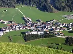 Center of Westendorf | |
 Coat of arms | |
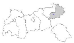 Location of Westendorf within Tyrol | |
 Westendorf Location within Austria | |
| Coordinates: 47°24′00″N 12°12′00″E | |
| Country | Austria |
| State | Tyrol |
| District | Kitzbühel |
| Government | |
| • Mayor | Annemarie Plieseis |
| Area | |
| • Total | 95.49 km2 (36.87 sq mi) |
| Elevation | 783 m (2,569 ft) |
| Population (2018-01-01)[2] | |
| • Total | 3,652 |
| • Density | 38/km2 (99/sq mi) |
| Time zone | UTC+1 (CET) |
| • Summer (DST) | UTC+2 (CEST) |
| Postal code | 6363 |
| Area code | 05334 |
| Vehicle registration | KB |
| Website | www.westendorf.tirol.gv.at |
Geography
Westendorf lies on a sunny terrace of the Brixental valley, at the foot of the Choralpe. The parish consists of a clustered village (Haufendorf) and other hamlets and farmsteads in the surrounding area, as well as an industrial estate. To the south the Windautal, a popular recreation area, branches off.
A large part of the parish is wooded or used for agricultural purposes.
Rivers: The Brixentaler Ache and the Windauer Ache flow through the parish.
Mountains: Important mountains are the Hohe Salve (1,828m), the Steinbergstein (2,215m), the Kröndlhorn (2,444m) and the Brechhorn (2,032m).
Population
| Year | Pop. | ±% |
|---|---|---|
| 1869 | 1,324 | — |
| 1880 | 1,370 | +3.5% |
| 1890 | 1,300 | −5.1% |
| 1900 | 1,367 | +5.2% |
| 1910 | 1,605 | +17.4% |
| 1923 | 1,648 | +2.7% |
| 1934 | 1,802 | +9.3% |
| 1939 | 1,783 | −1.1% |
| 1951 | 2,034 | +14.1% |
| 1961 | 2,228 | +9.5% |
| 1971 | 2,681 | +20.3% |
| 1981 | 2,810 | +4.8% |
| 1991 | 3,157 | +12.3% |
| 2001 | 3,454 | +9.4% |
| 2011 | 3,597 | +4.1% |
See also
References
- "Dauersiedlungsraum der Gemeinden Politischen Bezirke und Bundesländer - Gebietsstand 1.1.2018". Statistics Austria. Retrieved 10 March 2019.
- "Einwohnerzahl 1.1.2018 nach Gemeinden mit Status, Gebietsstand 1.1.2018". Statistics Austria. Retrieved 9 March 2019.