Westley, California
Westley is a census-designated place (CDP) in Stanislaus County, California. The population was 603[2][3] at the 2010 census, down from 747 at the 2000 census. It is part of the Modesto Metropolitan Statistical Area.
Westley | |
|---|---|
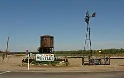 A scene in Westley, California | |
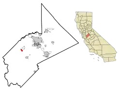 Location in Stanislaus County and the state of California | |
| Coordinates: 37°32′54″N 121°12′5″W | |
| Country | |
| State | |
| County | Stanislaus |
| Area | |
| • Total | 1.743 sq mi (4.515 km2) |
| • Land | 1.743 sq mi (4.515 km2) |
| • Water | 0 sq mi (0 km2) 0% |
| Elevation | 89 ft (27 m) |
| Population | |
| • Total | 603[2][3] |
| [2][3] | |
| Time zone | UTC-8 (Pacific (PST)) |
| • Summer (DST) | UTC-7 (PDT) |
| ZIP code | 95387 |
| Area code(s) | 209 |
| FIPS code | 06-84480 |
| GNIS feature ID | 0237554 |
History
The Oxford Tire Pile
Oxford Energy had a major stake in a major local scrap tire pile operation.[4][5][6][7][8] It was the largest single collection of waste tires on the west coast, when it mostly burnt down in 1997.[4][5]
Filbin had begun trucking used tires into Ed's Tire Disposal even before construction of I-5,[9] the road being built between 1956 and 1979, depending on location.[9] Oxford Energy had begun dumping near Westley in various piles since the 1950s.[4][5]
Oxford Energy officials heard about it causing an eyesore and environmental blight in 1984 and approached both Filbin and the county, proposing the tire-to-energy project, but it was turned down on environmental grounds.[9]
It was under a 24 hour security guarding regime in 1987.[9]
About 10,000-20,000 tires were being dumped there each day during 1987.[9]
In 1997, when dump had grown to about 6,000,000 tires during 1997 the state stepped in under a special local legislative mandate to dispose of them.[4][5]
Shortly after the local photographer, Mr Burtynsky, had photographed Oxford Pile #8 during 1997, a lightning strike in the facility started a fire in the old tire pile[4][5] that took weeks to extinguish.[4][5]
Geography
Westley is located at 37°32′54″N 121°12′5″W (37.548255, -121.201264).[10] According to the United States Census Bureau, the CDP has a total area of 1.7 square miles (4.4 km2), all of it land.
Westley lies at the base of the Diablo Range, in the vicinity of Ingram Creek. Somewhat nearby is the San Joaquin Fault. East of the San Joaquin Fault there is a flow pattern of alluvium reported as a mud flow.[11] This flow pattern was deposited in the early Holocene period or the late Pleistocene.[12]
Demographics
2010
At the 2010 census Westley had a population of 603. The population density was 345.9 people per square mile (133.6/km2). The racial makeup of Westley was 212 (35.2%) White, 0 (0.0%) African American, 5 (0.8%) Native American, 1 (0.2%) Asian, 0 (0.0%) Pacific Islander, 368 (61.0%) from other races, and 17 (2.8%) from two or more races. Hispanic or Latino of any race were 579 people (96.0%).[14]
The census reported that 601 people (99.7% of the population) lived in households, 2 (0.3%) lived in non-institutionalized group quarters, and no one was institutionalized.
There were 149 households, 99 (66.4%) had children under the age of 18 living in them, 96 (64.4%) were opposite-sex married couples living together, 25 (16.8%) had a female householder with no husband present, 12 (8.1%) had a male householder with no wife present. There were 8 (5.4%) unmarried opposite-sex partnerships, and 1 (0.7%) same-sex married couples or partnerships. 14 households (9.4%) were one person and 7 (4.7%) had someone living alone who was 65 or older. The average household size was 4.03. There were 133 families (89.3% of households); the average family size was 4.32.
The age distribution was 242 people (40.1%) under the age of 18, 51 people (8.5%) aged 18 to 24, 159 people (26.4%) aged 25 to 44, 111 people (18.4%) aged 45 to 64, and 40 people (6.6%) who were 65 or older. The median age was 25.9 years. For every 100 females, there were 102.3 males. For every 100 females age 18 and over, there were 97.3 males.
There were 157 housing units at an average density of 90.1 per square mile, of the occupied units 32 (21.5%) were owner-occupied and 117 (78.5%) were rented. The homeowner vacancy rate was 0%; the rental vacancy rate was 4.9%. 102 people (16.9% of the population) lived in owner-occupied housing units and 499 people (82.8%) lived in rental housing units.
2000
At the 2000 census there were 747 people, 139 households, and 128 families in the CDP. The population density was 445.4 people per square mile (171.7/km2). There were 151 housing units at an average density of 90.0 per square mile (34.7/km2). The racial makeup of the CDP was 39.36% White, 1.07% African American, 2.41% Native American, 0.54% Asian, 0.27% Pacific Islander, 53.82% from other races, and 2.54% from two or more races. Hispanic or Latino of any race were 83.94%.[15]
Of the 139 households 67.6% had children under the age of 18 living with them, 76.3% were married couples living together, 11.5% had a female householder with no husband present, and 7.2% were non-families. 7.2% of households were one person and 3.6% were one person aged 65 or older. The average household size was 4.38 and the average family size was 4.54.
The age distribution was 36.8% under the age of 18, 12.4% from 18 to 24, 30.1% from 25 to 44, 17.1% from 45 to 64, and 3.5% 65 or older. The median age was 26 years. For every 100 females, there were 126.4 males. For every 100 females age 18 and over, there were 137.2 males.
The median household income was $20,417 and the median family income was $21,458. Males had a median income of $16,691 versus $23,750 for females. The per capita income for the CDP was $6,137. About 42.6% of families and 64.9% of the population were below the poverty line, including 68.3% of those under age 18 and 27.8% of those age 65 or over.
Government
In the California State Legislature, Westley is in the 12th Senate District, represented by Democrat Anna Caballero, and the 21st Assembly District, represented by Democrat Adam Gray.[16]
In the United States House of Representatives, Westley is in California's 10th congressional district, represented by Democrat Josh Harder.[17]
See also
References
- "2010 Census Gazetteer Files - Places - California". United States Census Bureau. Retrieved March 26, 2015.
- "Westley, California (CA 95387) profile: population, maps, real estate, averages, homes, statistics, relocation, travel, jobs, hospitals, schools, crime, moving, houses, news, sex offenders". www.city-data.com.
- Staff, Website Services & Coordination. "2010 Census Interactive Population Map (Text Version) - U.S. Census Bureau". www.census.gov. Archived from the original on 2014-07-15.
- Westerbeck, Colin (16 April 2006). "Oxford Tire Pile #8, Westley, California" – via LA Times.
- "Terribly charasmatic piles of tires". 28 November 2011.
- "Oxford tire pile #7, Westley, California".
- "Oxford Tire Pile #1, Westley California - Hood Museum". hoodmuseum.dartmouth.edu.
- "Oil". Edward Burtynsky.
- Taylor, Ronald B. (30 November 1987). "Massive Pile of Tires Fuels Controversial Energy Plan" – via LA Times.
- "US Gazetteer files: 2010, 2000, and 1990". United States Census Bureau. 2011-02-12. Retrieved 2011-04-23.
- C.Michael Hogan, Marc Papineau, Ballard George, et al., Environmental Assessment for the Proposed Residential and Commercial Development at the Westley Interchange, Earth Metrics Inc., Report 10529C, California State Environmental Clearinghouse, Sacramento, Ca., July, 1990
- Bartow, Geologic map of the East Flank of the Diablo Range from Hospital Creek to Poverty Flats (1985)
- "Westley, CA - USA.com™". www.usa.com.
- "2010 Census Interactive Population Search: CA - Westley CDP". U.S. Census Bureau. Archived from the original on July 15, 2014. Retrieved July 12, 2014.
- "U.S. Census website". United States Census Bureau. Retrieved 2008-01-31.
- "Statewide Database". Regents of the University of California. Retrieved March 26, 2015.
- "California's 10th Congressional District - Representatives & District Map". Civic Impulse, LLC. Retrieved September 28, 2014.
| Wikimedia Commons has media related to Westley, California. |
Municipalities and communities of Stanislaus County, California, United States | ||
|---|---|---|
| Cities |  Stanislaus County map | |
| CDPs | ||
| Unincorporated communities | ||
| Ghost towns | ||
| ||
| Authority control |
|---|