Wherryman's Way
Wherryman's Way is a long-distance footpath in the English county of Norfolk.[1]
| Wherryman's Way | |
|---|---|
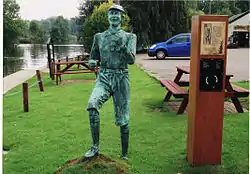 Life-size sculpture of Billy Bluelight at Woods End public house near Bramerton on the route of the Wherryman's Way | |
| Length | 56 km (35 mi) |
| Location | Norfolk |
| Trailheads | Norwich 52.6268°N 1.3061°E Great Yarmouth 52.6063°N 1.7368°E |
| Use | Walking |
| Hiking details | |
| Season | All year round |
Route
Wherryman's Way is 35 miles (56 km) in length, running between Norwich and Great Yarmouth. It follows the course of the River Yare where possible, with some significant stretches away from the river where there is no continuous path alongside the Yare. Where the River Chet meets the Yare, it follows the former upstream to Loddon and then largely uses roads to the Reedham Ferry to cross the River Yare.
From Reedham the route is along the northern bank of the Yare the rest of the way, passing Berney Arms where it joins the route of the Weavers' Way. The two routes then follow the northern edge of Breydon Water before going under Breydon Bridge and into Great Yarmouth. By Vauxhall Bridge next to Great Yarmouth railway station a sculpture marks the end points of the Wherryman's Way, Weavers' Way and Angles Way.
The trail is named after the trading wherries which used the River Yare to travel inland to Norwich.
Media
In September, 2011 Future Radio broadcast a 5-episode series of documentaries about the Wherryman's Way. This was funded by the Broads Authority Sustainable Development Fund. [2]
External links
- Wherryman's Way Official Website
- Wherryman's Way Blog
- Wherryman's Way on the Norfolk County Council website.
- Map of the trail on the Norfolk County Council website.
References
- Wherryman's Way on the LDWA website
- Future Radio's Wherrymans' Way documentaries, Retrieved 31 October 2012
Further reading
Silk, Steve The Wherryman's Way (2010) ISBN 1-84114-852-0
| Wikimedia Commons has media related to Wherryman's Way. |