White Hall, Albemarle County, Virginia
White Hall is an unincorporated community in Albemarle County, Virginia.[1]
White Hall | |
|---|---|
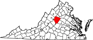
 White Hall Location within the Commonwealth of Virginia  White Hall White Hall (the United States) | |
| Coordinates: 38°07′04″N 78°39′41″W | |
| Country | United States |
| State | Virginia |
| County | Albemarle |
| Time zone | UTC−5 (Eastern (EST)) |
| • Summer (DST) | UTC−4 (EDT) |
| GNIS feature ID | 1477940[1] |
"Whitehall, in the northwestern portion of the county, was an election precinct known as Glenn's Store, William Maupin's Store, Maupin's Tavern, Miller's Store, Shumate's Tavern, until 1835. Then, it was named Whitehall for a White family living in the community. Pop. 55; elev. 722."[2]
Whitehall was an election district, and was also previously named Glenn's Store; William Maupin's Store; Maupin's Tavern; Miller's Tavern; Shumate's Tavern, until the present name was established in 1835.[3]
The Virginia house of Delegates passed Bill 111 on December 19, 1849 for a survey of a road from Shumate's Tavern to Covington, Virginia in Alleghany County, Virginia.[4] In January 1849 a grant in aid was proposed to intersect the turnpike from Vance's on the Huntersville and Warm Springs Turnpike to the Jackson's River Turnpike at John Shumate's Tavern, a distance of about 15 miles.[5][6]
References
- "White Hall". Geographic Names Information System. United States Geological Survey. Retrieved August 13, 2013.
- Hanson, Raus McDill. Virginia Place Names: Derivations : Historical Uses. 1969. Pages 25-28.
- Woods, Edgar. Albemarle County in Virginia: Giving Some Account of What It Was by Nature, of What It Was Made by Man, and of Some of the Men Who Made It. Charlottesville, Va: The Michie Company, Printers, 1901. Page 22.
- Journal of the House of Delegates of the Commonwealth of Virginia. 1849.
- Annual Reports of Officers, Boards and Institutions of the Commonwealth of Virginia. Page 208.
- Acts of the General Assembly of the State of Virginia. 1849. Page 92.
External links