White Ruthenia
White Ruthenia (Church Slavonic: Бѣла Роусь, Bela Rous; Belarusian: Белая Русь, Biełaja Ruś ; Russian: Белая Русь, Belaya Rus; Ukrainian: Біла Русь, Bila Rus) alternatively known as Russia Alba, White Rus' or White Russia, is an archaism[1][2] for the eastern part of present-day Belarus, including the cities of Połack (Polotsk), Viciebsk (Vitebsk), and Mahiloŭ (Mogilev).
History
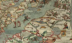
Many other variations of this name appeared on ancient maps; for instance, Russia Alba, Russija Alba, Wit Rusland, Weiß Reußen (Weißreußen), White Russia, Hviterussland, Hvíta Rússland, Weiß Russland (Weißrussland), Ruthenia Alba, Ruthénie Blanche and Weiß Ruthenien (Weißruthenien). The name was also assigned to various territories, often quite distant from that of present Belarus. For example, at one time the term was applied to Novgorod.
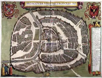
The 16th century chronicler Alexander Guagnini's book Sarmatiae Europeae descriptio wrote that Rus' was divided in three parts. The first part, under the rule of the Moscovite Grand Duke, was called White Russia. The second one, under the rule of Polish king, was called Black Russia. And the rest was Red Ruthenia. He also said Moscow was the center of White Russia and Russian metropolitanate, and that Grand Duke of Moscow was called the White Czar, especially by his subjects.
Only by the late 16th century, the name was associated with the area of present Belarus. The origins of the name, which is attested from the 14th century, are unclear.
References
- "White Russia". Oxforddictionaries.com. 2013. Retrieved 24 October 2017.
- "White Russian". Oxforddictionaries.com. 2017. Retrieved 24 October 2017.
General references
- Akta Aleksandra, króla polskiego, wielkiego księcia litewskiego i t.d. (1501—1506). Wyd. F. Papee. Kraków, 1927
- Alexandrowicz S. Rozwój kartografii Wielkiego Księstwa Litewskiego od XV do połowy XVIII w. Poznań, 1989
- Anonymi Dvbnicensis. Liber de rebus Lvdovici R. H.. Analecta Monumentorum Hungariae historicum literarorium maximum inedita. Budapestini, 1986
- I.V. Bellum Prutenum. Smereka E. Zbiór pisarzy polsko–lacińskich. Leopoli, 3, 1933
- Colker M. L. America rediscovered in thirteenth century?. Speculum. A journal of medieval studies. Cambridge. Vol. 54. No. 4. October 1979
- Cosmographey oder beschreibung aller Laender, Herrschaften, fürnemsten Stetten... Beschriben durch Sebastianum Münsterum... Basel, 1550; Ulrichs von Richental Chronik des Constanzer Concils 1414 bis 1418. Herausgegeben von M. R. Buck. Tübingen, 1882
- Cromer M. Polonia sive de situ, populis, moribus, magistratibus et republica regni Poloni libri duo. Cracoviae, 1901. (паўтоp выданьня 1578 г.)
- Der Weiss Kunig. Eine Erzählung von den Thaten Kaiser Maximilian der Ersten. Wien, 1775
- Historica Russiae monumenta ex antiquis exterarum gentium arcivis et bibliothecis deprompta ab A. I. Turgenevio. V. I. Petropoli, 1841 (Акты исторические, относящиеся к России, извлечённые из иностранных архивов и библиотек А. И. Тургеневым)
- Historiae Ruthenicae Scriptores exteri saeculi XVI. V. I—II. Berolini et Petropoli, 1841—42
- Kronika Jana z Czarnkowa (Joannis de Czarnkow. Chronicon Polonorum). Оprac. J. Szlachtowski. Monumenta Poloniae Historica Lwów, T. II. 1872
- Nordenskiöld, Adolf Erik Facsimile-Atlas to the Early History of Cartography with Reproductions of the Most Important Maps Printed in the XV and XVI Centuries. Stockholm, 1889. Замысловский Е. Е. Геpбеpштейн и его истоpико–геогpафические известия о России. СПб., 1884
- Il Mappamondo di Fra Mauro. A cura di Tullio Gasparini Leporace. Presentazione di Roberto Almagia. Venezia, 1956
- Ioannes Stobnicensis. Introductio in Ptolomei Cosmographiam. Cracoviae, 1512
- Ostrowski W. About the origin of the name «White Russia». London, 1975
- Peter Suchenwirt’s Werke aus dem vierzehnten Jahrhundert. Hrsg. von Alois Primisser. Wien, 1827
- Prisschuch Th. Des conzilis grundveste. Die historischen Volkslieder der Deutschen vom 13. bis 6. Jahrhundert. Bd. 1. Leipzig, 1865
- Prochaska A. Codex epistolaris Vitoldi. Cracoviae, 1882
- Rude & barbarous kingdom. Russia in the accounts of sixteenth-century English voyagers. Ed. by Lloyd E. Berry and Robert O. Crummey. Madison—London, 1968
- Sarmatiae Europeae descriptio. Ab Alexandro Guagnino Veronensi. Poloniae Historiae Corpus. Ex bibliotheca Ioan. Pistorii Nidani. Per Sebastiani Henric Petri. V. I. Basileae, 1588
- Scriptores Rerum Hungaricarum tempore ducum regumque stirpis Arpadianae gestarum. Vol. II. Budapest, 1938
- Starowolski Sz. Polska albo opisanie położenia królestwa Polskiego. Kraków, 1976
- Stryikowski M. Kronika Polska, Litewska, Żmódzka i wszystkiej Rusi. T. I-II. Warszawa, 1846
- Witkowska M. H. S. Vita sanctae Kyngae ducissae Cracoviensis. Roczniki Humanistyczne. T. X, z. 2. Lublin, 1961.
- Імя тваё «Белая Русь». Мн., 1991
- Опись архива Посольского приказа 1626 г. Ч. 1. М., 1977
- Порецкий Я. И. Соломон Рысинский * Solomo Pantherus Leucorussus. Мн., 1983
- ПСРЛ. Т. 2. СПб., 1843; Т. 25. М.—Л., 1949
- Рыбаков Б. А. Русские карты Московии XV — начала XVI в. М., 1974
- Савельева Е. А. Hовгоpод и Hовгоpодская земля в западноевропейской каpтогpафии XV—XVI вв.. Геогpафия России XV—XVIII вв. (по сведениям иностpанцев). Л., 1984
- Слово избpанное от святых писаний еже на латыню. Попов А. Н. Историко–литературный обзор дpевнеpусских полемических сочинений пpотив латинян. М., 1875