White Store Township, Anson County, North Carolina
White Store Township, population 506, is one of eight townships in Anson County, North Carolina. White Store Township is 60.59 square miles (156.9 km2)[1] in size and located in southwestern Anson County. White Store Township does not contain any municipalities.
White Store Township, Anson County, North Carolina | |
|---|---|
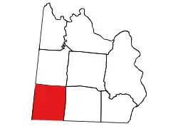 Location of White Store Township in Anson County | |
 Location of Anson County in North Carolina | |
| Country | United States |
| State | North Carolina |
| County | Anson |
| Area | |
| • Total | 60.59 sq mi (156.94 km2) |
| Highest elevation [2] (high point at northeast end of township) | 630 ft (190 m) |
| Lowest elevation [2] (Thompson Creek, where it flows out of the township in the southeast corner) | 236 ft (72 m) |
| Population (2010) | |
| • Total | 506[3] |
| • Density | 8.35/sq mi (3.22/km2) |
| Time zone | UTC-4 (EST) |
| • Summer (DST) | UTC-5 (EDT) |
| Area code(s) | 704 |
Geography
The northwest end of White Store Township is drained by Brown Creek and its tributary, Black Jack Branch. The southeast end is drained by Deadfall Creek and its tributaries, Shaw Creek, Bell Creek, and Boles Creek. The extreme southeast corner is drained by Thompson Creek. Savannah Branch drains a small part of the southern part of the township.[4]
References
- "NC OneMap". www.nconemap.gov. State of North Carolina. Retrieved 14 October 2020.
- "The National Map - Service Endpoints". viewer.nationalmap.gov. US Geological Survey. Retrieved 18 October 2020.
- "US Census Bureau Populations". data.census.gov. US Census Bureau. Retrieved 18 October 2020.
- "North Carolina Flood Hazard Area Effective". www.nconemap.gov. State of North Carolina. Retrieved 17 October 2020.
Municipalities and communities of Anson County, North Carolina, United States | ||
|---|---|---|
| Towns |  | |
| Unincorporated community | ||
| Ghost town | ||
| ||
This article is issued from Wikipedia. The text is licensed under Creative Commons - Attribution - Sharealike. Additional terms may apply for the media files.