Whitehope Heights
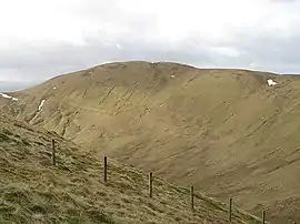
Whitehope Heights is a hill in the Moffat Hills range, part of the Southern Uplands of Scotland. The lowest Donald hill in the range, it is separated from Hart Fell by a steep grassy cleuch known as The Gyle. Like its neighbour, the Dumfries and Galloway-Scottish Borders border runs along its summit.[3] The southern slopes of the hill are part of the Corehead hill farm, an area owned by the Borders Forest Trust for the purposes of habitat regeneration; as a result, a large deer fence lines the boundary.[4] East of the Devil's Beef Tub and Annandale Way, it is most frequently climbed from this direction, but ascents from Hart Fell are also common.[5]
| Whitehope Heights | |
|---|---|
 | |
| Highest point | |
| Elevation | 637 m (2,090 ft) [1] |
| Prominence | 109 m (358 ft) [1] |
| Listing | Hu,Tu,Sim, D,GT,DN,Y[2] |
| Geography | |
| Location | Dumfries and Galloway, Scottish Borders, Scotland |
| Parent range | Moffat Hills, Southern Uplands |
| OS grid | NT 09575 13898 |
| Topo map | OS Landranger 78 |
References
- "Whitehope Heights". www.hill-bagging.co.uk.
- "Database of British and Irish Hills: user guide". www.hills-database.co.uk.
- "New Donalds Map". www.mountainsofscotland.co.uk. Retrieved 2020-04-18.
- "Corehead & Devil's Beef Tub - Borders Forest Trust". bordersforesttrust.org. Retrieved 2020-04-18.
- "Whitehope Heights". www.hill-bagging.co.uk. Retrieved 2020-04-18.
This article is issued from Wikipedia. The text is licensed under Creative Commons - Attribution - Sharealike. Additional terms may apply for the media files.