Wiang Kaen District
Wiang Kaen (Thai: เวียงแก่น; IPA: [wīaŋ kɛ̀n]) is the easternmost district (amphoe) of Chiang Rai Province, northern Thailand.
Wiang Kaen
เวียงแก่น | |
|---|---|
.jpg.webp) Hills in Po, Wiang Khean | |
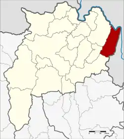 District location in Chiang Rai Province | |
| Coordinates: 20°6′44″N 100°30′49″E | |
| Country | Thailand |
| Province | Chiang Rai |
| Seat | Muang Yai |
| Area | |
| • Total | 526.0 km2 (203.1 sq mi) |
| Population (2005) | |
| • Total | 32,310 |
| • Density | 61.4/km2 (159/sq mi) |
| Time zone | UTC+7 (ICT) |
| Postal code | 57310 |
| Geocode | 5713 |
History
Historically, the area was Mueang Wiang Kaen, on the Ngao River. It was founded about the same time of Sukhothai Kingdom and Chiang Rai.
The government separated the three tambons Muang Yai, Po, and Lai Ngao from Chiang Khong District to create a minor district (king amphoe) on 1 April 1987.[1] It was upgraded to a full district on 7 September 1995.[2]
Geography
Neighboring districts are (from the south clockwise) Thoeng, Khun Tan, Chiang Khong of Chiang Rai Province. To the east lies Bokeo Province of Laos.
Phu Chi Fa, 1,442 m high, lies at the border with Thoeng District.[3]

Administration
The district is divided into four sub-districts (tambons), which are further subdivided into 41 villages (mubans). There are no municipal (thesabans), and four tambon administrative organizations (TAO).
| No. | Name | Thai name | Villages | Pop. | |
|---|---|---|---|---|---|
| 1. | Muang Yai | ม่วงยาย | 9 | 7,449 | |
| 2. | Po | ปอ | 20 | 15,946 | |
| 3. | Lai Ngao | หล่ายงาว | 6 | 3,490 | |
| 4. | Tha Kham | ท่าข้าม | 6 | 5,425 |
References
- ประกาศกระทรวงมหาดไทย เรื่อง แบ่งเขตท้องที่อำเภอเชียงของ จังหวัดเชียงราย ตั้งเป็นกิ่งอำเภอเวียงแก่น (PDF). Royal Gazette (in Thai). 104 (67 ง): 2484. April 9, 1987.
- พระราชกฤษฎีกาตั้งอำเภอด่านมะขามเตี้ย อำเภอแก่งหางแมว อำเภอภักดีชุมพล อำเภอเวียงแก่น อำเภอแม่วาง อำเภอถ้ำพรรณรา อำเภอบ่อเกลือ อำเภอโนนสุวรรณ อำเภอห้วยราช อำเภอแม่ลาน อำเภอบางแก้ว อำเภอป่าพะยอม อำเภอหนองม่วงไข่ อำเภอยางสีสุราช อำเภอจังหาร อำเภอบ้านธิ อำเภอภูสิงห์ อำเภอบางกล่ำ อำเภอวังม่วง และอำเภอนายูง พ.ศ. ๒๕๓๘ (PDF). Royal Gazette (in Thai). 112 (32 ก): 1–3. August 8, 1995.
- "Thoeng". Archived from the original on 2012-01-04. Retrieved 2012-02-15.
