Wieda (river)
The Wieda is a river in the German states of Lower Saxony and Thuringia.
| Wieda | |
|---|---|
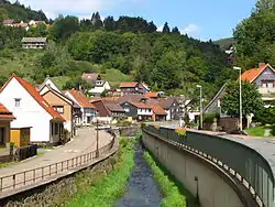 The Wieda in the village of Wieda | |
| Location | |
| Location | Counties of Göttingen in Lower Saxony and Nordhausen in Thuringia (Germany) |
| Reference no. | DE: 564822 |
| Physical characteristics | |
| Source | |
| • location | in the Harz on the Stöberhai |
| • coordinates | 51°39′43″N 10°33′23.8″E |
| • elevation | ca. 545 m above sea level (NHN) |
| Mouth | |
• location | near Woffleben into the Zorge |
• coordinates | 51°33′05.7″N 10°44′24.6″E |
• elevation | 206.9 m above sea level (NHN) |
| Length | 22 km [1] |
| Basin features | |
| Progression | Zorge → Helme → Unstrut → Saale → Elbe → North Sea |
| River system | Elbe |
| Tributaries | |
| • left | see below |
| • right | see below |
The Wieda has its source above the village of Wieda, flows through the village of Walkenried, the hamlet of Wiedigshof and the village of Gudersleben before discharging in the Harz river Zorge near Woffleben, a district of Ellrich. Its channel regularly dries up in the summer months - it sinks into the karst soil and reappears in other places as springs. Its most important tributary is the Uffe.
This article is issued from Wikipedia. The text is licensed under Creative Commons - Attribution - Sharealike. Additional terms may apply for the media files.