Wiehe
Wiehe is a town and a former municipality in the Kyffhäuserkreis district, in Thuringia, Germany. Since 1 January 2019, it is part of the town Roßleben-Wiehe. It is situated 24 kilometres (15 mi) south of Sangerhausen, and 32 kilometres (20 mi) north of Weimar.
Wiehe | |
|---|---|
Ortsteil of Roßleben-Wiehe | |
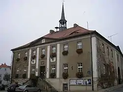 Town hall | |
 Coat of arms | |
Location of Wiehe 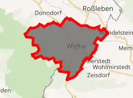
| |
 Wiehe 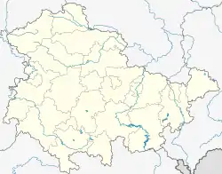 Wiehe | |
| Coordinates: 51°16′0″N 11°25′0″E | |
| Country | Germany |
| State | Thuringia |
| District | Kyffhäuserkreis |
| Town | Roßleben-Wiehe |
| Area | |
| • Total | 24.35 km2 (9.40 sq mi) |
| Elevation | 140 m (460 ft) |
| Population (2017-12-31) | |
| • Total | 1,871 |
| • Density | 77/km2 (200/sq mi) |
| Time zone | UTC+01:00 (CET) |
| • Summer (DST) | UTC+02:00 (CEST) |
| Postal codes | 06571 |
| Dialling codes | 034672 |
| Vehicle registration | KYF |
| Website | www.stadt-wiehe.de |
Location
Wiehe is located in the valley of the Unstrut on the northern slope of the Hohe Schrecke, a wooded mountain ridge. State roads 1215 and 1217 are the traffic connections to the surrounding area of Saxony-Anhalt and Thuringia.
Arms
Blazon: “In silver a haloed saint in a blue cloak, in his right hand a raised silver knife, holding a staff in his left hand; at his feet a black shield, inside a golden branch bend with three golden maple leaves."
The coat of arms shows St. Bartholomew, the patron saint of the parish church in Wiehe, with his attributes. The shield shows the family coat of arms of the Lords of Werthern, who held lordship initially through resale from 1453 and hereditarily from 1461 in the repeatedly divided Grafschaft Wiehe. The shield first appeared in the middle of the 16th century on a seal with the inscription: SIGILLVM CIVITATIS WIHE. On earlier seals, Bartholomew can be seen alone under a baldachin.[1]
Notable residents
_-_1875.jpg.webp)
- Karl Ferdinand Ranke (1802–1876), Classical philologist and teacher
- Leopold von Ranke (1795–1886), historian
- Friedrich Heinrich Ranke (1798–1876), Protestant theologian
- Ernst Ranke (1814–1888), Protestant theologian
- Hermann Necke (1850–1912), composer
References
- Neues Thüringer Wappenbuch vol. 2, p.32; Publisher: Arbeitsgemeinschaft Thüringen e. V. 1998 ISBN 3-9804487-2-X
| Authority control |
|---|
