Williams, Iowa
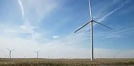
Williams is a city in Hamilton County, Iowa, United States. The population was 344 at the 2010 census. Williams is a regional center of wind power generation.
Williams, Iowa | |
|---|---|
 | |
 Location of Williams, Iowa | |
| Coordinates: 42°29′15″N 93°32′35″W | |
| Country | |
| State | |
| County | Hamilton |
| Area | |
| • Total | 0.87 sq mi (2.25 km2) |
| • Land | 0.87 sq mi (2.25 km2) |
| • Water | 0.00 sq mi (0.00 km2) |
| Elevation | 1,217 ft (371 m) |
| Population | |
| • Total | 344 |
| • Estimate (2019)[3] | 320 |
| • Density | 367.39/sq mi (141.92/km2) |
| Time zone | UTC-6 (Central (CST)) |
| • Summer (DST) | UTC-5 (CDT) |
| ZIP code | 50271 |
| Area code(s) | 515 |
| FIPS code | 19-85800 |
| GNIS feature ID | 0463052 |
Geography
Williams is located at 42°29′15″N 93°32′35″W (42.487464, -93.543190).[4]
According to the United States Census Bureau, the city has a total area of 0.87 square miles (2.25 km2), all land.[5]
Demographics
| Year | Pop. | ±% |
|---|---|---|
| 1880 | 79 | — |
| 1900 | 500 | +532.9% |
| 1910 | 457 | −8.6% |
| 1920 | 495 | +8.3% |
| 1930 | 500 | +1.0% |
| 1940 | 489 | −2.2% |
| 1950 | 519 | +6.1% |
| 1960 | 490 | −5.6% |
| 1970 | 456 | −6.9% |
| 1980 | 410 | −10.1% |
| 1990 | 368 | −10.2% |
| 2000 | 427 | +16.0% |
| 2010 | 344 | −19.4% |
| 2019 | 320 | −7.0% |
| Source:"U.S. Census website". United States Census Bureau. Retrieved 2020-03-29. and Iowa Data Center Source: | ||
2010 census
As of the census[2] of 2010, there were 344 people, 158 households, and 96 families living in the city. The population density was 395.4 inhabitants per square mile (152.7/km2). There were 183 housing units at an average density of 210.3 per square mile (81.2/km2). The racial makeup of the city was 98.8% White, 0.3% African American, and 0.9% from two or more races.
There were 158 households, of which 29.1% had children under the age of 18 living with them, 45.6% were married couples living together, 10.1% had a female householder with no husband present, 5.1% had a male householder with no wife present, and 39.2% were non-families. 35.4% of all households were made up of individuals, and 15.9% had someone living alone who was 65 years of age or older. The average household size was 2.18 and the average family size was 2.76.
The median age in the city was 42 years. 22.4% of residents were under the age of 18; 5.4% were between the ages of 18 and 24; 24.9% were from 25 to 44; 27.1% were from 45 to 64; and 20.1% were 65 years of age or older. The gender makeup of the city was 49.7% male and 50.3% female.
2000 census
As of the census[7] of 2000, there were 427 people, 185 households, and 123 families living in the city. The population density was 487.0 people per square mile (187.3/km2). There were 193 housing units at an average density of 220.1 per square mile (84.7/km2). The racial makeup of the city was 98.36% White, 1.64% from other races. Hispanic or Latino of any race were 2.58% of the population.
There were 185 households, out of which 25.4% had children under the age of 18 living with them, 55.7% were married couples living together, 8.1% had a female householder with no husband present, and 33.0% were non-families. 31.4% of all households were made up of individuals, and 18.4% had someone living alone who was 65 years of age or older. The average household size was 2.31 and the average family size was 2.85.
In the city, the population was spread out, with 24.8% under the age of 18, 6.8% from 18 to 24, 27.4% from 25 to 44, 20.6% from 45 to 64, and 20.4% who were 65 years of age or older. The median age was 39 years. For every 100 females, there were 100.5 males. For every 100 females age 18 and over, there were 92.2 males.
The median income for a household in the city was $36,250, and the median income for a family was $41,094. Males had a median income of $27,667 versus $22,188 for females. The per capita income for the city was $16,000. None of the families and 2.2% of the population were living below the poverty line, including no under eighteens and 7.8% of those over 64.
Education
It is within the Webster City Community School District.[8] It was formerly in the Northeast Hamilton Community School District,[9] until it merged into the Webster City district on July 1, 2019.[10]
References
- "2019 U.S. Gazetteer Files". United States Census Bureau. Retrieved July 17, 2020.
- "U.S. Census website". United States Census Bureau. Retrieved 2012-05-11.
- "Population and Housing Unit Estimates". United States Census Bureau. May 24, 2020. Retrieved May 27, 2020.
- "US Gazetteer files: 2010, 2000, and 1990". United States Census Bureau. 2011-02-12. Retrieved 2011-04-23.
- "US Gazetteer files 2010". United States Census Bureau. Retrieved 2012-05-11.
- "Census of Population and Housing". Census.gov. Retrieved June 4, 2015.
- "U.S. Census website". United States Census Bureau. Retrieved 2008-01-31.
- "Webster City" (PDF). Iowa Department of Education. Retrieved 2020-04-05. - Map of district prior to merger with Northeast Hamilton
- "Northeast Hamilton" (PDF). Iowa Department of Education. Archived from the original (PDF) on 2018-04-27. Retrieved 2020-04-05.
- "Iowa Educational Directory 2019-2020 School Year" (PDF). Iowa Department of Education. p. 175. Retrieved 2020-04-05. (PDF p. 177/186) - From section "REORGANIZATION & DISSOLUTION ACTIONS SINCE 1965-66"
Municipalities and communities of Hamilton County, Iowa, United States | ||
|---|---|---|
| Cities | Map of Iowa highlighting Hamilton County | |
| Unincorporated community | ||
| Footnotes | ‡This populated place also has portions in an adjacent county or counties | |
| ||
