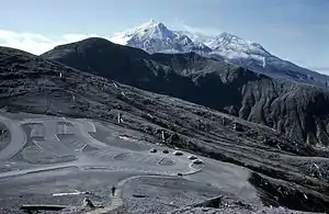
Windy Ridge (Mount St. Helens)
Windy Ridge is a ridge and eponymous Forest Highway in the Mount St. Helens National Volcanic Monument. The ridge goes between Windy Pass and Independence Pass, 1 mile (1.6 km) east of Spirit Lake.[1] Several road guides list Windy Ridge Road (NF-99) as one of the best roads in Washington State due to its good pavement, good views, and winding "sweeper" curves enjoyable to many drivers and motorcycle riders.[2][3][4][5] At the end of the road at 4,200 feet (1,300 m) elevation,[6] at 46°15′00″N 122°08′14″W above Spirit Lake, there is a viewpoint into the St. Helens crater.[7]
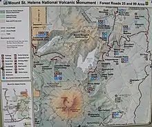
NF-99 meets Forest Road 25 near Wakepish Sno-park running to Windy Ridge and other Spirit Lake overlooks past places such as Bear Meadow Viewpoint, Miner's Car, Meta Lake and Cascade Peaks. This is one of the most popular back-country destinations on the Forest and Monument.[8]
References
- U.S. Geological Survey Geographic Names Information System: Windy Ridge (Skamania County, Washington)
- Bosworth & Sanders 2003 "Washington's twistiest road coated in a lacquer of smooth, dreamy pavement..."
- National Geographic 2018, p. 400.
-
Bruce Hansen (April 7, 2011), "Washington's Top 5", Rider,
[T]he twistiest roads in the whole of the Pacific Northwest
- Hansen 2016, pp. 252-259.
- Vielbig 1997, p. 66.
- U.S. Geological Survey Geographic Names Information System: Windy Ridge Viewpoint
- Forest Road 99 official website, U.S. National Forest Service, accessed 2018-09-12
Sources
- Bosworth, Brian; Sanders, Michael (2003), Destination Highways Washington, Twisted Edge Publishing, ISBN 0-9684328-1-6
- Hansen, Bruce (2016), Motorcycle Journeys Through the Pacific Northwest, Motorbooks, ISBN 0760352690
- Guide to Scenic Highways and Byways: The 300 Best Drives in the U. S., National Geographic Books, 2018, ISBN 1426219059
- Vielbig, Klindt (1997), Mount St. Helens National Volcanic Monument: For Hiking, Climbing, Skiing, and Nature Viewing, The Mountaineers Books
External links
| Wikimedia Commons has media related to Windy Ridge (Mount St. Helens). |
- Windy Ridge viewpoint, ScenicWA.com
- Windy Ridge and Mount St. Helens National Volcanic Monument, White Pass Scenic Byway
- Windy Ridge viewpoint, Mount St. Helens Science and Learning Center (Mount St. Helens Institute and the U.S. Forest Service)
![]() This article incorporates public domain material from the United States Government document: "Forest Road 99".
This article incorporates public domain material from the United States Government document: "Forest Road 99".