Wisconsin Highway 82
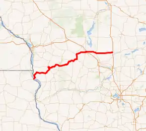
State Trunk Highway 82 (often called Highway 82, STH-82 or WIS 82) is a state highway in Wisconsin, United States. It runs east–west in southwest and south central Wisconsin from the Iowa border near Lansing, IA to Oxford.
| ||||
|---|---|---|---|---|
WIS 82 highlighted in red | ||||
| Route information | ||||
| Maintained by WisDOT | ||||
| Length | 116.15 mi[1] (186.93 km) | |||
| Major junctions | ||||
| West end | ||||
| East end | ||||
| Location | ||||
| Counties | Crawford, Vernon, Juneau, Adams, Marquette | |||
| Highway system | ||||
| ||||

This highway is a low traffic highway for its entire length.
Route description
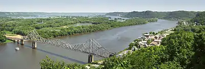
Highway 82 begins on the Wisconsin side of the Mississippi River near Lansing, Iowa. Its next junction with a highway is across the bridge at Wisconsin Highway 35. The highway then turns to the North, forming a short concurrency with State Highway 35. At De Soto, Wisconsin, the route turns away from the Mississippi River Basin, and heads Northeasterly in general.
The next settlement is Viroqua, where it forms a wrong-way concurrency with US Highway 14, US Highway 61, State Highway 27. This ends at the traffic light with Decker Street, where the road turns East, concurrent with Wisconsin Highway 56. This concurrency ends approximately 4 miles (6.4 km) East of Viroqua. Highway 82 turns left, to proceed to La Farge, while Highway 56 continues to Viola.

Major intersections
| County | Location | mi | km | Destinations | Notes |
|---|---|---|---|---|---|
| Mississippi River | 0.00 | 0.00 | Continuation into Iowa | ||
| Black Hawk Bridge; Iowa–Wisconsin state line | |||||
| Crawford | Town of Freeman | Southern end of WIS 35 overlap | |||
| De Soto | Northern end of WIS 35 overlap | ||||
| Vernon | Town of Franklin | Southern end of WIS 27 overlap | |||
| Southern end of US 14 / US 61 overlap | |||||
| Viroqua | Northern end of US 14 / US 61 and WIS 27 overlaps; western end of WIS 56 overlap | ||||
| Town of Viroqua | Eastern end of WIS 56 overlap | ||||
| La Farge | Western end of WIS 131 overlap | ||||
| Eastern end of WIS 131 overlap | |||||
| Town of Hillsboro | Western end of WIS 33 overlap | ||||
| Hillsboro | Southern end of WIS 80 overlap | ||||
| Juneau | Union Center | Eastern end of WIS 33 overlap | |||
| Elroy | |||||
| Northern end of WIS 80 overlap | |||||
| Mauston | Roundabout; southern end of WIS 58 overlap | ||||
| Northern end of WIS 58 overlap | |||||
| Adams | Town of Springville | ||||
| Marquette | Oxford–Packwaukee town line | Roadway continues as northbound WIS 23 | |||
1.000 mi = 1.609 km; 1.000 km = 0.621 mi
| |||||
See also
 U.S. Roads portal
References
- Bessert, Chris. "Wisconsin Highways: Highways 80-89 (Highway 82)". Wisconsin Highways. Retrieved 2007-03-20.
External links
 Media related to Wisconsin Highway 82 at Wikimedia Commons