Wolds Top
Wolds Top (sometimes also Normanby Hill[1]) is the name sometimes given to the highest point of the Lincolnshire Wolds. It lies some distance to the north of the village of Normanby le Wold in Lincolnshire. The Viking Way passes close by, on a minor road, and there is a radio mast near the summit. The summit is marked with an Ordnance Survey triangulation station, which was erected in 1936, and is now used as part of the Ordnance Survey National GPS System.[2]
| Wolds Top | |
|---|---|
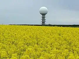 The National Air Traffic Control Radar Installation (Claxby) | |
| Highest point | |
| Elevation | 168 m (551 ft) |
| Prominence | 162 m (531 ft) |
| Parent peak | Walton Hill |
| Listing | Marilyn, County Top |
| Coordinates | 53°27′09″N 0°18′48″W |
| Geography | |
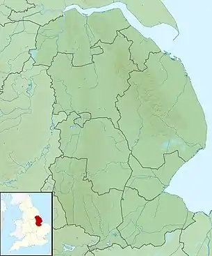 Wolds Top Location of Wolds Top in Lincolnshire | |
| Location | Lincolnshire Wolds, England |
| OS grid | TF121964 |
| Topo map | OS Landranger 113 |
Wolds Top is within the Lincolnshire Wolds Area of Outstanding Natural Beauty.[3][4]
References
- The Hardys – The UK's Highest Points. Accessed on 15 March 2013.
- Lincolnshire Wolds North (Map) (A1 ed.). 1:25000. Explorer. Ordnance survey of Great Britain. 3 April 2006. § 282. ISBN 978-0319238233.
- "AONB outline map". Magic map. DEFRA. Retrieved 21 October 2013. (specify location as grid ref. TF121964 to add the hill location or zoom in.)
- "NCA Profile: 43 Lincolnshire Wolds (NE440)". Publications and products. Natural England. Retrieved 13 October 2013.
This article is issued from Wikipedia. The text is licensed under Creative Commons - Attribution - Sharealike. Additional terms may apply for the media files.
