Wolf Creek Pass
Wolf Creek Pass is a high mountain pass on the Continental Divide, in the San Juan Mountains of Colorado. It is the route through which U.S. Highway 160 passes from the San Luis Valley into southwest Colorado on its way to New Mexico and Arizona. The pass is notable as inspiration of a C. W. McCall song. The pass is significantly steep on either side (6.8% maximum grade) and can be dangerous in winter. There are two runaway truck ramps on the westbound side for truckers that lose control of their brakes.[2][3]
| Wolf Creek Pass | |
|---|---|
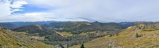
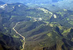 Wolf Creek Pass and Ski Area, August 2008 | |
| Elevation | 10,857 ft (3,309 m)[1] |
| Traversed by | |
| Location | Mineral County, Colorado, United States |
| Range | San Juan Mountains |
| Coordinates | 37°29′00″N 106°48′11″W[1] |
| Topo map | USGS Wolf Creek Pass |
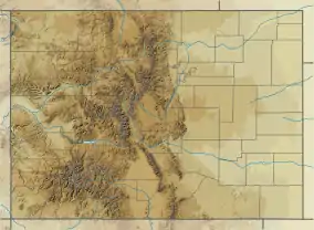 Wolf Creek Pass Location in Colorado | |
Expansion
Wolf Creek Pass, once a two-lane road winding through the San Juan Mountains between South Fork, Colorado, and Pagosa Springs, has been expanded into a multi-lane highway, greatly increasing the traffic capacity of the pass and making it more navigable in bad weather. It is the easiest access to southwest Colorado from the rest of the state, as all remaining overland routes require lengthy detours through New Mexico or over Lizard Head Pass, near Telluride, or the intimidating Red Mountain Pass, a two-lane road winding along sheer cliffs from Ouray to Silverton.
History
According to historical documents, the creation of the first road along Wolf Creek Pass began in 1911 and finished construction in 1916. The project's engineers were J. E. Maloney and Ed Riley.[4] The 12 feet wide road was doubled in width in 1930 and was paved 20 years later.[5]
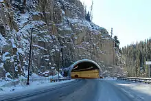
A 900-foot (270 m) tunnel on the eastern portion was opened November 5, 2005. Construction was completed in the Summer of 2006, with the highway fully widened and drainage projects along the route completed.[6]
Attractions
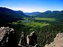
The Lobo Overlook, at 11,760 feet elevation on the north side of the pass, provides commanding views of the continental divide.[7]
The pass is also home to Wolf Creek ski area located on the eastern side of the Continental Divide on Highway 160. Also on the eastern side is one of the largest RV parks in the United States, located just a few miles west of South Fork, Colorado.
Wolf Creek Pass is also an attraction for tourists, as it is known for the natural beauty of the wilderness the highway passes through. Just west of the pass, Treasure Falls offers passersby a view of a mountain waterfall.
Name
The pass was named for Wolf Creek,[8] which starts near the top of the pass and flows down its western side to a confluence with the West Fork San Juan River in Mineral County.
Controversy
For decades, a major resort project proposed by Texas billionaire Red McCombs has been causing controversy in the area. The proposed resort would be situated near the summit of the pass and support over 8,000 people.[9] People familiar with the high alpine environment and water issues in the area question the wisdom of a resort style village at 10,000' elevation.[10] McCombs has been working with the Forest Service to acquire highway access to the property, which is an inholding.
Over several decades the Forest Service has been the target of multiple lawsuits from community groups for incompletely assessing the environmental impacts of approving a highway access point to the property[11][12] and withholding information requested through the Freedom of Information Act.[13] Following the most recent lawsuit, the developers reached agreement not to break ground at the site until the case is resolved in court.[14]
Opponents of the "Village" state that the development would likely harm a vital wildlife corridor between the Weminuche and South San Juan Wilderness areas, alter backcountry experiences on Wolf Creek Pass, compete with local businesses in nearby Pagosa Springs and South Fork, adversely affect rare fen wetlands, and stress water supplies in the Rio Grande watershed.[10][15] Proponents claim the "Village" would improve the economics of the region.[16]
C. W. McCall
Wolf Creek Pass was made famous in 1975 by country music artist C. W. McCall's spoken word song of the same name, in which the pass is described as "37 miles o' hell – which is up on the Great Divide." The song describes the truck careening down through a "tunnel" (during which process several crates of chickens stacked on the back of the truck are inadvertently lost) and eventually into a feed store in Pagosa Springs.
Climate
Wolf Creek Pass has a subarctic climate (Dfc) with substantial precipitation year round, though it may be called a subalpine climate due to it having a different climate than other climates on a similar latitude due to its high elevation. Summer usually consists of mild days and chilly nights. Winter consists of cold days with nightly lows close to zero lasting from early November to sometimes into April. Annual snowfall is heavy, averaging 435.6 inches (1,106 cm), one of highest in the entire state, usually beginning by late September and not ceasing until sometimes early June. March averages the highest snowpack of the year at 67 inches 170.2 cm).[17]
| Climate data for near Wolf Creek Pass, Colorado (Elevation 10,640ft) | |||||||||||||
|---|---|---|---|---|---|---|---|---|---|---|---|---|---|
| Month | Jan | Feb | Mar | Apr | May | Jun | Jul | Aug | Sep | Oct | Nov | Dec | Year |
| Record high °F (°C) | 57 (14) |
63 (17) |
61 (16) |
69 (21) |
73 (23) |
80 (27) |
80 (27) |
78 (26) |
81 (27) |
68 (20) |
65 (18) |
56 (13) |
81 (27) |
| Average high °F (°C) | 30.2 (−1.0) |
31.0 (−0.6) |
34.4 (1.3) |
40.9 (4.9) |
51.3 (10.7) |
60.9 (16.1) |
65.8 (18.8) |
63.8 (17.7) |
56.7 (13.7) |
48.1 (8.9) |
37.0 (2.8) |
30.8 (−0.7) |
45.9 (7.7) |
| Average low °F (°C) | 4.4 (−15.3) |
6.3 (−14.3) |
10.5 (−11.9) |
17.5 (−8.1) |
27.6 (−2.4) |
35.0 (1.7) |
40.6 (4.8) |
39.4 (4.1) |
33.7 (0.9) |
24.3 (−4.3) |
13.1 (−10.5) |
6.0 (−14.4) |
21.5 (−5.8) |
| Record low °F (°C) | −30 (−34) |
−25 (−32) |
−20 (−29) |
−12 (−24) |
−1 (−18) |
9 (−13) |
21 (−6) |
15 (−9) |
13 (−11) |
−10 (−23) |
−28 (−33) |
−27 (−33) |
−30 (−34) |
| Average precipitation inches (mm) | 3.71 (94) |
4.02 (102) |
4.97 (126) |
3.37 (86) |
2.10 (53) |
1.75 (44) |
3.60 (91) |
4.54 (115) |
4.39 (112) |
4.50 (114) |
4.16 (106) |
4.30 (109) |
45.39 (1,153) |
| Average snowfall inches (cm) | 73.4 (186) |
66.4 (169) |
77.8 (198) |
41.5 (105) |
12.7 (32) |
1.3 (3.3) |
0 (0) |
0 (0) |
3.2 (8.1) |
26.2 (67) |
54.5 (138) |
78.7 (200) |
435.6 (1,106) |
| Source: The Western Regional Climate Center[18] | |||||||||||||
References
- "B 162". NGS data sheet. U.S. National Geodetic Survey.
- "CDOT Warns Truckers: BEWARE THE WOLF" (Press release). Colorado Department of Transportation Region 5. 2017-06-15.
- "A Beer Truck Had To Take A CO Runaway Ramp". 94.3 X. 2017-07-17.
- "Wolf Creek Pass turned 103 this year". Del Norte Prospector. Retrieved 2020-11-22.
- "Wolf Creek Pass – South Fork–Pagosa Springs". www.uncovercolorado.com. Retrieved 2020-11-21.
- "Wolf Creek Pass, Colorado, Web Cams". www.keno.org. Retrieved 2020-11-21.
- "Wolf Creek Pass & Lobo Overlook, Colorado". HikingMike.com. Retrieved 26 September 2019.
- "Tales told with markers". The Colorado Magazine. Vol. 47 no. 3. 1970. p. 240. Retrieved 2019-08-24.
- "The Village at Wolf Creek". Retrieved December 18, 2015.
- http://www.friendsofwolfcreek.org/
- Blevins, Jason (June 29, 2015). "Village at Wolf Creek opponents sue to undo Forest Service land swap". The Denver Post. Retrieved December 18, 2015.
- Marcus, Peter (June 24, 2015). "Village at Wolf Creek faces hurdle". The Durango Herald. Retrieved December 18, 2015.
- Grover, Hannah (November 8, 2015). "Extension granted in Wolf Creek lawsuit". Farmington Daily Times. Retrieved December 18, 2015.
- Blevins, Jason (December 18, 2015). "Deal delays start of Village at Wolf Creek construction". The Denver Post. Retrieved December 18, 2015.
- "SJCA Guide to Wolf Creek". San Juan Citizens Alliance. Retrieved December 18, 2015.
- Barber, Megan (December 3, 2014). "Plans Move Forward on Controversial Village at Wolf Creek". Curbed Ski. Retrieved December 18, 2015.
- "WOLF CREEK PASS 1 E, COLORADO - Climate Summary". wrcc.dri.edu. Retrieved 2020-06-28.
- "Seasonal Temperature and Precipitation Information". Western Regional Climate Center. Retrieved November 18, 2013.
External links
| Wikimedia Commons has media related to Wolf Creek Pass. |