South Fork, Colorado
South Fork is a statutory town in Rio Grande County, Colorado, United States. It lies at the confluence of the South Fork and Rio Grande rivers. The population was 386 at the 2010 census.
Town of South Fork, Colorado | |
|---|---|
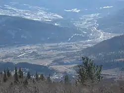 South Fork as seen from the summit of Agua Ramon Mountain | |
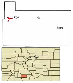 Location of South Fork in Rio Grande County, Colorado. | |
| Coordinates: 37°40′9″N 106°38′34″W | |
| Country | |
| State | |
| County[1] | Rio Grande County |
| Incorporated | May 19, 1992[2] |
| Government | |
| • Type | Statutory Town[1] |
| Area | |
| • Total | 2.50 sq mi (6.47 km2) |
| • Land | 2.50 sq mi (6.47 km2) |
| • Water | 0.00 sq mi (0.00 km2) |
| Elevation | 8,209 ft (2,502 m) |
| Population (2010) | |
| • Total | 386 |
| • Estimate (2019)[5] | 425 |
| • Density | 170.14/sq mi (65.69/km2) |
| Time zone | UTC-7 (Mountain (MST)) |
| • Summer (DST) | UTC-6 (MDT) |
| ZIP code[6] | 81154 |
| Area code(s) | 719 |
| FIPS code | 08-72395 |
| GNIS feature ID | 0203420 |
| Website | Town of South Fork |
Geography
South Fork is located at 37°40′09″N 106°38′34″W.[7]
According to the United States Census Bureau, the town has a total area of 2.4 square miles (6.2 km2), all land.
History
South Fork was once the site of timber milling operations.[8]
South Fork was founded in 1882, by which date its location was already marked by the presence of a coaching post, dating from the construction of the railroad connection of the Rio Grande Western Railroad line to Creede, which had been built to support the Creede silver mine. It was only in 1992 that South Fork achieved independent statutory town status, making it the youngest statutory town in the state. Originally the principal economic activities involved forestry and mining, but in recent decades these have been overtaken in the employment statistics by tourism.
Demographics
| Historical population | |||
|---|---|---|---|
| Census | Pop. | %± | |
| 2000 | 604 | — | |
| 2010 | 386 | −36.1% | |
| 2019 (est.) | 425 | [5] | 10.1% |
| U.S. Decennial Census[9] | |||
South Fork has about 600 permanent residents, but a substantially larger summer population due to seasonal residents and visitors.[8]
As of the census[10] of 2000, there were 604 people, 274 households, and 187 families residing in the town. The population density was 255.2 people per square mile (98.4/km2). There were 580 housing units at an average density of 245.1 per square mile (94.5/km2). The racial makeup of the town was 92.88% White, 0.17% African American, 0.33% Native American, 0.17% Asian, 2.98% from other races, and 3.48% from two or more races. Hispanic or Latino of any race were 12.42% of the population.
There were 274 households, out of which 25.5% had children under the age of 18 living with them, 58.0% were married couples living together, 8.8% had a female householder with no husband present, and 31.4% were non-families. 27.7% of all households were made up of individuals, and 7.3% had someone living alone who was 65 years of age or older. The average household size was 2.20 and the average family size was 2.63.
In the town, the population was spread out, with 21.7% under the age of 18, 7.1% from 18 to 24, 24.5% from 25 to 44, 29.1% from 45 to 64, and 17.5% who were 65 years of age or older. The median age was 43 years. For every 100 females, there were 96.1 males. For every 100 females age 18 and over, there were 99.6 males.
The median income for a household in the town was $36,667, and the median income for a family was $45,417. Males had a median income of $32,188 versus $19,063 for females. The per capita income for the town was $26,128. About 4.1% of families and 6.1% of the population were below the poverty line, including 6.7% of those under age 18 and 1.6% of those age 65 or over.
Cultural references
In the 1983 movie National Lampoon's Vacation starring Chevy Chase as Clark Griswold, the Griswold family spend the night at a camping ground in South Fork.
See also
- Outline of Colorado
- State of Colorado
- Colorado cities and towns
- Colorado municipalities
- Colorado counties
- Colorado cities and towns
- San Juan Mountains
References
- "Active Colorado Municipalities". State of Colorado, Department of Local Affairs. Archived from the original on 2009-12-12. Retrieved 2007-09-01.
- "Colorado Municipal Incorporations". State of Colorado, Department of Personnel & Administration, Colorado State Archives. 2004-12-01. Retrieved 2007-09-02.
- "2019 U.S. Gazetteer Files". United States Census Bureau. Retrieved July 1, 2020.
- "US Board on Geographic Names". United States Geological Survey. 2007-10-25. Retrieved 2008-01-31.
- "Population and Housing Unit Estimates". United States Census Bureau. May 24, 2020. Retrieved May 27, 2020.
- "ZIP Code Lookup" (JavaScript/HTML). United States Postal Service. Retrieved 2008-01-03.
- "US Gazetteer files: 2010, 2000, and 1990". United States Census Bureau. 2011-02-12. Retrieved 2011-04-23.
- Bruce Finley (June 23, 2013). "West Fork fire complex at nearly 66,200 acres and feeding on beetle-ravaged forests". Denver Post.
- "Census of Population and Housing". Census.gov. Retrieved June 4, 2015.
- "U.S. Census website". United States Census Bureau. Retrieved 2008-01-31.
External links
Municipalities and communities of Rio Grande County, Colorado, United States | ||
|---|---|---|
| City | 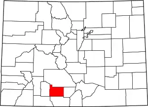 Map of Colorado highlighting Rio Grande County | |
| Towns | ||
| CDPs | ||
| Unincorporated community | ||
| Footnotes | ‡This populated place also has portions in an adjacent county or counties | |
| ||
| Authority control |
|
|---|