Wolfsberg, Carinthia
Wolfsberg [ˈvɔlfsbɛʁk] (Slovene: Volšperk) is a town in Carinthia, Austria, the capital of Wolfsberg District.
Wolfsberg | |
|---|---|
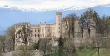
 Riverside and Wolfsberg Castle | |
_COA.svg.png.webp) Coat of arms | |
 Wolfsberg Location within Austria | |
| Coordinates: 46°51′N 14°50′E | |
| Country | Austria |
| State | Carinthia |
| District | Wolfsberg |
| Government | |
| • Mayor | Hans-Peter Schlagholz (SPÖ) |
| Area | |
| • Total | 278.31 km2 (107.46 sq mi) |
| Elevation | 463 m (1,519 ft) |
| Population (2018-01-01)[2] | |
| • Total | 25,035 |
| • Density | 90/km2 (230/sq mi) |
| Time zone | UTC+1 (CET) |
| • Summer (DST) | UTC+2 (CEST) |
| Postal code | 9400 |
| Area code | 04352 |
| Website | www.wolfsberg.at |
Geography
The town is situated within the Lavanttal Alps, west of the Koralpe range in the valley of the Lavant River, a left tributary of the Drava. In the northeast, the road up to the Packsattel mountain pass connects Wolfsberg with Voitsberg in Styria. Wolfsberg's municipal area of 279 km2 (108 sq mi) is the fourth largest in Austria.

The municipality comprises 40 cadastral communities (Surface area in hectares 31. Dezember 2019):
- Aichberg (1.897,01 ha)
- Auen (600,55 ha)
- Forst (2.458,67 ha)
- Gräbern-Prebl (1.495,09 ha)
- Gries (93,78 ha)
- Hartelsberg (1.188,11 ha)
- Hattendorf (243,20 ha)
- Hintertheißenegg (1.444,63 ha)
- Kleinedling (435,20 ha)
- Kleinwinklern (48,62 ha)
- Lading (2.335,45 ha)
- Leiwald (1.428,66 ha)
- Michaelsdorf (348,40 ha)
- Oberleidenberg (1.162,33 ha)
- Paildorf (138,81 ha)
- Pfaffendorf (101,08 ha)
- Preims (1.939,64 ha)
- Priel (296,13 ha)
- Reding (149,89 ha)
- Reideben (114,35 ha)
- Reisberg (1.245,59 ha)
- Rieding (1.210,13 ha)
- Ritzing (92,89 ha)
- St. Jakob (107,35 ha)
- St. Johann (112,12 ha)
- St. Marein (110,33 ha)
- St. Margarethen (237,03 ha)
- St. Michael (470,82 ha)
- St. Stefan (732,21 ha)
- Schoßbach (14,49 ha)
- Schwemmtratten (45,88 ha)
- Thürn (516,80 ha)
- Unterleidenberg (334,56 ha)
- Vordergumitsch (545,23 ha)
- Vordertheißenegg (778,12 ha)
- Waldenstein (1.019,73 ha)
- Weißenbach (125,86 ha)
- Witra (2.185,37 ha)
- Wolfsberg Obere Stadt (15,49 ha)
- Wolfsberg Untere Stadt (11,20 ha)
The municipal area is divided into 65 villages (population in brackets as of the 1st of January 2020):
- Aichberg (255)
- Altendorf (415)
- Arling (51)
- Auen (810)
- Eselsdorf (27)
- Forst (292)
- Glein (62)
- Gräbern (121)
- Gries (1221)
- Großedling (243)
- Hartelsberg (166)
- Hartneidstein (31)
- Hattendorf (447)
- Hintertheißenegg (38)
- Kleinedling (1838)
- Kleinwinklern (86)
- Klippitztörl (43)
- Kötsch (12)
- Kragelsdorf (72)
- Lading (236)
- Lading Sonnseite (236)
- Lausing (55)
- Leiwald (12)
- Magersdorf (54)
- Maildorf (115)
- Michaelsdorf (223)
- Oberleidenberg (376)
- Paildorf (223)
- Pfaffendorf (121)
- Pollheim (381)
- Prebl (305)
- Preims (97)
- Priel (3032)
- Raggl (146)
- Reding (2852)
- Reideben (68)
- Reinfelsdorf (75)
- Reisberg (127)
- Rieding (276)
- Riegelsdorf (54)
- Ritzing (574)
- Schilting (64)
- Schleife (549)
- Schoßbach (189)
- Schwemmtratten (426)
- Siegelsdorf (227)
- St. Jakob (865)
- St. Johann (1056)
- St. Marein (363)
- St. Margarethen im Lavanttal (886)
- St. Michael (538)
- St. Stefan (1723)
- St. Thomas (203)
- Thürn (198)
- Unterleidenberg (217)
- Völking (175)
- Vordergumitsch (164)
- Vordertheißenegg (216)
- Waldenstein (126)
- Weißenbach Gumitsch (71)
- Weißenbach Rieding (35)
- Witra (121)
- Wois (8)
- Wolfsberg (718)
- Wolkersdorf (134)
- Wölling (121)
History
The area of Wolfsberg belonged to the estates within the medieval Duchy of Carinthia that were ceded to the Prince-Bishopric of Bamberg, probably already by Emperor Henry II in 1007. The castle above the town was first mentioned as Wolfsperch in an 1178 deed of St. Paul's Abbey in the Lavanttal. The adjacent settlement became the administrative centre of Bamberg's Carinthian territories and in 1331 received town privileges by Prince-Bishop Werntho Schenk von Reicheneck.
During the Protestant Reformation the Bayerhofen Castle residence, first mentioned in 1239 and rebuilt in the 16th century, became a center of Lutheranism, which nevertheless was suppressed by the Counter-Reformation. In 1759 the Habsburg empress Maria Theresa acquired all Bamberg lands in Carinthia. Wolfsberg Castle was purchased by Count Hugo Henckel von Donnersmarck in 1846 and rebuilt in a Tudorbethan style.
In World War II the village of Priel south of the town center was the site of the Stalag XVIII-A prisoner-of-war camp with about 7,000 inmates. After the war it served as a detention camp run by the British occupation forces.
Politics

Seats in the municipal council (Gemeinderat) as of 2015 local elections:
- Social Democratic Party of Austria (SPÖ): 20
- Freedom Party of Austria (FPÖ): 5
- Austrian People's Party (ÖVP): 5
- NEOS: 3
- The Greens – The Green Alternative: 2
Notable people
- Hermann Schmid (born 1939), actor and director
- Ulrich Habsburg-Lothringen (born 1941), nobleman and politician (The Greens)
- Walter Kogler (born 1967), football player and coach
- Heinz Arzberger (born 1972), football goalkeeper
- Elisabeth Köstinger (born 1978), politician (ÖVP)
- Patrick Friesacher (born 1980), racing driver
- Kai Schoppitsch (born 1980), football player
- Christian Prawda (born 1982), football player
- Eva Wutti (born 1989), triathlete and cyclist
The poet Christine Lavant (1915–1973) died in the Wolfsberg state hospital.
References
- "Dauersiedlungsraum der Gemeinden Politischen Bezirke und Bundesländer - Gebietsstand 1.1.2018". Statistics Austria. Retrieved 10 March 2019.
- "Einwohnerzahl 1.1.2018 nach Gemeinden mit Status, Gebietsstand 1.1.2018". Statistics Austria. Retrieved 9 March 2019.
- Amt der Kärntner Landesregierung Archived 2015-05-25 at the Wayback Machine
External links
| Wikimedia Commons has media related to Wolfsberg. |
