Wyola, Montana
Wyola is a census-designated place (CDP) in Big Horn County, Montana, United States. The population was 215 at the 2010 census.[1] 79% of the residents are Native American, and the majority are members of the Crow Nation.[2]
Wyola, Montana | |
|---|---|
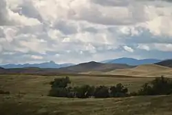 Landforms near Wyola, Montana | |
 Location of Wyola, Montana | |
| Coordinates: 45°7′35″N 107°23′36″W | |
| Country | United States |
| State | Montana |
| County | Big Horn |
| Area | |
| • Total | 6.7 sq mi (17.4 km2) |
| • Land | 6.7 sq mi (17.4 km2) |
| • Water | 0.0 sq mi (0.0 km2) |
| Elevation | 3,720 ft (1,134 m) |
| Population (2010) | |
| • Total | 215 |
| • Density | 32/sq mi (12.3/km2) |
| Time zone | UTC-7 (Mountain (MST)) |
| • Summer (DST) | UTC-6 (MDT) |
| ZIP code | 59089 |
| Area code(s) | 406 |
| FIPS code | 30-82075 |
| GNIS feature ID | 0778710 |
Geography
Wyola is located at 45°7′35″N 107°23′36″W (45.126409, -107.393430).[3]
According to the United States Census Bureau, the CDP has a total area of 6.7 square miles (17.4 km2), all land.[1]
Climate
| Climate data for Wyola, Montana | |||||||||||||
|---|---|---|---|---|---|---|---|---|---|---|---|---|---|
| Month | Jan | Feb | Mar | Apr | May | Jun | Jul | Aug | Sep | Oct | Nov | Dec | Year |
| Average high °F (°C) | 36.2 (2.3) |
40.6 (4.8) |
47.9 (8.8) |
59.8 (15.4) |
69.3 (20.7) |
78.1 (25.6) |
88.1 (31.2) |
87.0 (30.6) |
75.3 (24.1) |
63.8 (17.7) |
47.4 (8.6) |
39.0 (3.9) |
61.1 (16.2) |
| Average low °F (°C) | 8.2 (−13.2) |
12.6 (−10.8) |
19.9 (−6.7) |
29.5 (−1.4) |
38.1 (3.4) |
46.0 (7.8) |
51.0 (10.6) |
48.8 (9.3) |
39.7 (4.3) |
30.6 (−0.8) |
19.6 (−6.9) |
11.6 (−11.3) |
29.6 (−1.3) |
| Average precipitation inches (mm) | 0.7 (18) |
0.7 (18) |
1.1 (28) |
2.0 (51) |
2.6 (66) |
2.4 (61) |
1.2 (30) |
0.8 (20) |
1.6 (41) |
1.4 (36) |
0.8 (20) |
0.7 (18) |
15.9 (400) |
| Average snowfall inches (cm) | 10.4 (26) |
9.3 (24) |
10.5 (27) |
6.8 (17) |
0.9 (2.3) |
0.1 (0.25) |
0 (0) |
0 (0) |
1.2 (3.0) |
2.5 (6.4) |
7.5 (19) |
9.8 (25) |
59 (149.95) |
| Source: Weatherbase [4] | |||||||||||||
Demographics
As of the census[5] of 2000, there were 186 people, 52 households, and 43 families residing in the CDP. The population density was 26.0 people per square mile (10.0/km2). There were 57 housing units at an average density of 8.0 per square mile (3.1/km2). The racial makeup of the CDP was 18.82% White, 79.03% Native American, and 2.15% from two or more races. Hispanic or Latino of any race were 2.15% of the population.
There were 52 households, out of which 48.1% had children under the age of 18 living with them, 55.8% were married couples living together, 23.1% had a female householder with no husband present, and 17.3% were non-families. 13.5% of all households were made up of individuals, and 5.8% had someone living alone who was 65 years of age or older. The average household size was 3.58 and the average family size was 4.00.
In the CDP, the population was spread out, with 41.4% under the age of 18, 8.6% from 18 to 24, 23.1% from 25 to 44, 18.3% from 45 to 64, and 8.6% who were 65 years of age or older. The median age was 25 years. For every 100 females, there were 100.0 males. For every 100 females age 18 and over, there were 101.9 males.
The median income for a household in the CDP was $20,536, and the median income for a family was $18,750. Males had a median income of $29,375 versus $15,625 for females. The per capita income for the CDP was $7,815. About 39.5% of families and 48.0% of the population were below the poverty line, including 64.7% of those under the age of eighteen and 14.3% of those 65 or over.
Notable person
- Bill Yellowtail, former candidate for the Montana seat in the United States House of Representatives, is from Wyola.
References
- "Geographic Identifiers: 2010 Demographic Profile Data (G001): Wyola CDP, Montana". U.S. Census Bureau, American Factfinder. Archived from the original on February 12, 2020. Retrieved June 25, 2013.
- Olp, Susan (2012-07-07). "Crow members bring language, history alive to elementary school students". Missoulian / Billings Gazette. Retrieved 2013-04-26.
- "US Gazetteer files: 2010, 2000, and 1990". United States Census Bureau. 2011-02-12. Retrieved 2011-04-23.
- "Weatherbase: Historical Weather for Wyola, Montana". Weatherbase. 2011. Retrieved on November 24, 2011.
- "U.S. Census website". United States Census Bureau. Retrieved 2008-01-31.
Municipalities and communities of Big Horn County, Montana, United States | ||
|---|---|---|
| City | 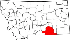 Big Horn County map | |
| Town | ||
| CDPs | ||
| Unincorporated communities | ||
| Indian reservations | ||
| Footnotes | ‡This populated place also has portions in an adjacent county or counties | |
| ||