Yanawara (Arequipa)
Yanawara (Quechua yana black, wara trousers,[2] "black trousers", Hispanicized spelling Yanahuara) is a mountain in the Andes of Peru, about 5,267.2 metres (17,281 ft) high. It is located in the Arequipa Region, Castilla Province, on the border of the districts Andagua, Ayo and Machaguay. Yanawara lies south-west of P'aqu Urqu and north of Qullpa, Yanqha and Yana Urqu (Quechua for "black mountain", Hispanicized Yana Orcco).[3]
| Yanawara | |
|---|---|
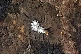 Coropuna (snow-covered) and Yanawara (lower right rim of this image) as seen from the ISS (north is to the upper right) | |
| Highest point | |
| Elevation | 5,267.2 m (17,281 ft) [1] |
| Coordinates | 15°35′53″S 72°23′28″W |
| Geography | |
 Yanawara Peru | |
| Location | Peru, Arequipa Region, Castilla Province |
| Parent range | Andes |
References
- "South America Maps". Joint Operations Graphic. Retrieved July 7, 2014.
- Teofilo Laime Ajacopa, Diccionario Bilingüe Iskay simipi yuyayk'ancha, La Paz, 2007 (Quechua-Spanish dictionary)
- escale.minedu.gob.pe - UGEL map of the Castilla Province (Arequipa Region)
This article is issued from Wikipedia. The text is licensed under Creative Commons - Attribution - Sharealike. Additional terms may apply for the media files.