Yokoshibahikari
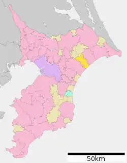
Yokoshibahikari (横芝光町, Yokoshibahikari-machi) is a town located in Chiba Prefecture, Japan.[1] As of 1 April 2020, the town had an estimated population of 23,467 in 9771 households and a population density of 350 persons per km².[2] The total area of the town is 66.91 square kilometres (25.83 sq mi). .
Yokoshibahikari
横芝光町 | |
|---|---|
 Hamlet of Hikari, Chiba | |
 Flag  Seal | |
 Location of Yokoshibahikari in Chiba Prefecture | |
 Yokoshibahikari Location of Yokoshibahikari in Chiba Prefecture | |
| Coordinates: 35°40′N 140°30′E | |
| Country | Japan |
| Region | Kantō |
| Prefecture | Chiba |
| District | Sanbu |
| Area | |
| • Total | 66.91 km2 (25.83 sq mi) |
| Population (April 2020) | |
| • Total | 23,467 |
| • Density | 350/km2 (910/sq mi) |
| Time zone | UTC+9 (Japan Standard Time) |
| City symbols | |
| • Tree | Prunus mume |
| • Flower | Sakura |
| • Bird | Little tern |
| Phone number | 0479-84-1211 |
| Address | 11902 Miyagawa, Yohoshibahikaro-machi, Chiba-ken 289-1727 |
| Website | Official website |
Geography
Yokoshibahikari is located in northeastern Bōsō Peninsula, bordered by the Pacific Ocean to the east. It is about 35 kilometers from the prefectural capital at Chiba, and about 60 to 70 kilometers from the center of Tokyo. The town lacks a center, but instead consists of a collection of hamlets scattered over the countryside extending from the Yokoshiba Station on the Sōbu Main Line. Given such sparse structure, it takes quite a long time for the bus lines to serve the whole town. The coastal area of Yokoshibahikari, which makes up part of Kujūkuri Beach, is protected as part of Kujūkuri Prefectural Natural Park.[1]
Climate
Yokoshibahikari has a Humid subtropical climate (Köppen Cfa) characterized by warm summers and cool winters with light to no snowfall. The average annual temperature in Yokoshibahikari is 15.0 °C. The average annual rainfall is 1556 mm with September as the wettest month. The temperatures are highest on average in August, at around 26.0 °C, and lowest in January, at around 5.1 °C.[3]
Demographics
Per Japanese census data,[4] the population of Yokoshibahikari has remained relatively constant over the past 60 years.
| Year | Pop. | ±% |
|---|---|---|
| 1920 | 18,838 | — |
| 1930 | 19,346 | +2.7% |
| 1940 | 19,998 | +3.4% |
| 1950 | 26,729 | +33.7% |
| 1960 | 24,884 | −6.9% |
| 1970 | 23,192 | −6.8% |
| 1980 | 25,387 | +9.5% |
| 1990 | 26,430 | +4.1% |
| 2000 | 26,721 | +1.1% |
| 2010 | 24,679 | −7.6% |
History
Yokoshibahikari spans the border between the former provinces of Kazusa and Shimōsa. The village of Asahi was established in Sanbu District with the establishment of the modern municipalities system on April 1, 1889. It changed its name to Yokoshiba on December 28, 1892 and was raised to town status on February 1, 1955. The town of Hikari in Sōsa District was created by the merger of four villages on May 3, 1954. Yokoshibahikari was formed by the merger on March 27, 2006 of the towns of Hikari and Yokoshiba. Sōsa District was dissolved as a result of this merger.
Government
Yokoshibahikari has a mayor-council form of government with a directly elected mayor and a unicameral town council of 16 members. Yokoshibahikari, together with neighboring Sanmu and the municipalities of Sanmu District collectively contributes two members to the Chiba Prefectural Assembly. In terms of national politics, the town is part of Chiba 10th district of the lower house of the Diet of Japan.
Economy
Agriculture has been a mainstay of the economy of Yokoshibahikari since early times. The town has a cool winter and mild summer. Other than extensive rice cultivation, the town is a center of production of negi, the Welsh onion, tomatoes, and kabocha, a Japanese variety of winter squash. Pig and dairy farms are also found in the town.[1] The town traditionally produced ceramics. In 1991 the northern part of the town was designated as the Yokoshiba Industrial Park due to its close proximity to Narita International Airport.
Education
Yokoshibahikari has seven public elementary schools and two public middle schools operated by the town government, and one public high school operated by the Chiba Prefectural Board of Education.
Transportation
Noted people from Sodegaura
- Konishiki Yasokichi I, Sumo wrestler
Local attractions
- Shibayama Kofun cluster, a National Historic Site
- Kujūkuri Beach
Gallery
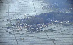
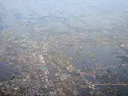 Yokoshiba (foreground) and Miyagawa (background)
- Hikari (near Arai)
References
- "横芝光(町)" [Yokoshibahikari]. Nihon Daihyakka Zensho (Nipponika) (in Japanese). Tokyo: Shogakukan. 2012. OCLC 153301537. Retrieved 2012-09-28.
- "Yokoshibahikari town official statistics" (in Japanese). Japan.
- Yokoshibahikari climate data
- Yokoshibahikari population statistics
External links
| Wikimedia Commons has media related to Yokoshibahikari, Chiba. |
- Official Website (in Japanese)
| Chiba |
| |||
|---|---|---|---|---|
| Core cities | ||||
| Cities | ||||
| Districts | ||||