Yubara, Okayama
Yubara (湯原町, Yubara-chō) was a town located in Maniwa District, Okayama Prefecture, Japan.
Yubara
湯原町 | |||||||||||||
|---|---|---|---|---|---|---|---|---|---|---|---|---|---|
Former municipality | |||||||||||||
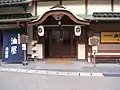
 Former Yubara town hall | |||||||||||||
 Yubara Location in Japan | |||||||||||||
| Coordinates: 35°11′41.9″N 133°43′52.9″E | |||||||||||||
| Country | Japan | ||||||||||||
| Region | Chūgoku | ||||||||||||
| Prefecture | Okayama Prefecture | ||||||||||||
| District | Maniwa | ||||||||||||
| Merged | March 31, 2005 (now part of Maniwa) | ||||||||||||
| Area | |||||||||||||
| • Total | 141.37 km2 (54.58 sq mi) | ||||||||||||
| Population (2003) | |||||||||||||
| • Total | 3,310 | ||||||||||||
| • Density | 23.41/km2 (60.6/sq mi) | ||||||||||||
| Time zone | UTC+09:00 (JST) | ||||||||||||
| |||||||||||||
As of 2003, the town had an estimated population of 3,310 and a density of 23.41 persons per km2. The total area was 141.37 km2.
On March 31, 2005, Yubara, along with the town of Hokubō (from Jōbō District), and towns of Katsuyama, Kuse and Ochiai, and the villages of Chūka, Kawakami, Mikamo and Yatsuka (all from Maniwa District) were merged to create the city of Maniwa.
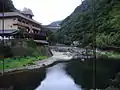
The historic town is nestled in a ravine and follows the meandering path of the Asahi River. The village is surrounded, on all sides by trees clinging to the hillsides. (There are small logging operations in the region that the bus passes on the way into town.) The town sits at the base of Yubara Dam. There are a number onsen hotels. There is also an outdoor, mixed bathing bath, or rotenburo, by the river. This facility is free. The waters are said to have healing effects on those suffering from diabetes, chronic women's diseases, chronic skin disease, cuts and burns.[1]
Geography
- Rivers: Asahi River (The big-3 river through Okayama Prefecture)
Education
- Yubara Elementary School
- Futakawa Elementary School
- Yubara Junior High School
Transportation
- Expressways:
- Yonago Expressway
- Yubara Interchange
- Yonago Expressway
- National highways:
- Prefectural roads:
External links
- Official website of Maniwa in Japanese
- Yubara Onsen