Yuryuzan (river)
The Yuryuzan (Russian: Юрюза́нь, Yuryuzán; Bashkir: Йүрүҙән, Yürüðän) is a river in the Republic of Bashkortostan and Chelyabinsk Oblast in Russia, a left tributary of the Ufa (Kama basin).[1] The length of the river is 404 kilometers (251 mi). The area of its basin is 7,240 square kilometers (2,800 sq mi).[2] The Yuryuzan flows into the Pavlovskoye Reservoir near Karaidel. It freezes up in the second half of October – early December and stays under the ice until April. The river is navigable within the first 16 kilometers (9.9 mi) of its estuary. The towns of Yuryuzan and Ust-Katav are located on the river Yuryuzan. The Yuryuzan is very popular river for easy rafting.
| Yuryuzan | |
|---|---|
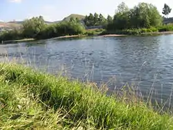 Yuryuzan river near Ust-Katav in Chelyabinsk Oblast. | |
| Location | |
| Country | Russia |
| Physical characteristics | |
| Source | |
| • location | Yamantaw, South Urals |
| • coordinates | 54°17′39″N 58°14′28″E |
| • elevation | 960 m (3,150 ft) |
| Mouth | Pavlovskoye Reservoir |
• coordinates | 55°42′20″N 56°58′15″E |
• elevation | 140 m (460 ft) |
| Length | 404 km (251 mi) |
| Basin size | 7,240 km2 (2,800 sq mi) |
| Discharge | |
| • average | 55 m3/s (1,900 cu ft/s) |
| Basin features | |
| Progression | Ufa→ Belaya→ Kama→ Volga→ Caspian Sea |
The name of the river originates from the Bashkir language and means "The big river".
References
- Юрюзань (река), Great Soviet Encyclopedia
- «Река Юрюзань», Russian State Water Registry