Zabukovica
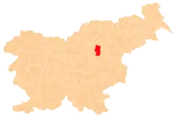
Zabukovica (pronounced [zaˈbuːkɔʋitsa]) is a settlement in the Municipality of Žalec in east-central Slovenia. It lies in the hills south of Žalec. The area is part of the traditional region of Styria. The Municipality of Žalec is included in the Savinja Statistical Region.[2] Zabukovica includes the hamlets of Kurja Vas, Močle, Odele, Podvine, Porence, Slovenski Dol (locally Tajčental, formerly Nemški Dol[3]), Sončni Hrib, and Zabukovška Vas (or simply Vas).[4]
Zabukovica | |
|---|---|
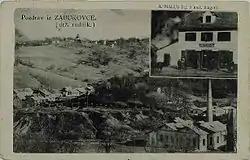 1931 postcard of Zabukovica | |
 Zabukovica Location in Slovenia | |
| Coordinates: 46°12′49.5″N 15°9′44.64″E | |
| Country | |
| Traditional region | Styria |
| Statistical region | Savinja |
| Municipality | Žalec |
| Area | |
| • Total | 3.46 km2 (1.34 sq mi) |
| Elevation | 362.4 m (1,189.0 ft) |
| Population (2002) | |
| • Total | 931 |
| [1] | |
Mass grave
Zabukovica is the site of a mass grave associated with the Second World War. The Liboje Pond Mass Grave (Slovene: Grobišče ribnik Liboje) is located east of Zabukovica, neat the Potočnik farm (Zabukovica no. 147). The remains of unknown victims were discovered at the site by children after the war. The pond was created after the war.[5]
References
- Statistical Office of the Republic of Slovenia
- Žalec municipal site
- Orožen, Janko. 1959. "Kratka zgodovina rudarstva in industrije v Spodnji Savinjski dolini." In: Drago Predal (ed.), Savinjski zbornik, pp. 213–230. Celje: Občinski odbor SZDL v Žalcu, p. 218.
- Savnik, Roman, ed. 1976. Krajevni leksikon Slovenije, vol. 3. Ljubljana: Državna založba Slovenije. pp. 537–538.
- Ferenc, Mitja (December 2009). "Grobišče ribnik Liboje". Geopedia (in Slovenian). Ljubljana: Služba za vojna grobišča, Ministrstvo za delo, družino in socialne zadeve. Retrieved May 13, 2020.
External links
| Settlements | Administrative centre: Žalec
|  | ||||
|---|---|---|---|---|---|---|
| Landmarks | ||||||
