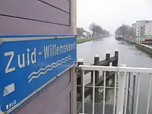
Zuid-Willemsvaart
The Zuid-Willemsvaart (Dutch: [zœytˈʋɪləmsfaːrt]; translated: South William's Canal) is a canal in the south of the Netherlands and the east of Belgium.
| Zuid-Willemsvaart | |
|---|---|
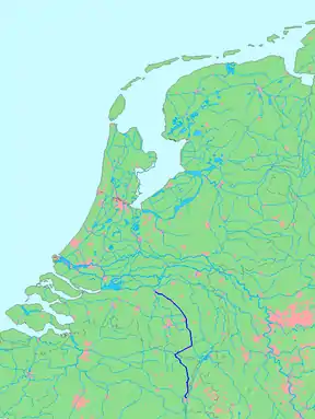 Map of the Zuid-Willemsvaart | |
| Country | Netherlands, Belgium |
| Specifications | |
| Length | 121.9 km (75.7 miles) |
| Status | Open |
| History | |
| Date completed | 1826 |
| Geography | |
| Start point | Bassin, Maastricht |
| End point | Dieze, 's-Hertogenbosch |
| Beginning coordinates | 50.856618°N 5.691782°E |
| Ending coordinates | 51.695768°N 5.301044°E |
Route
The Zuid-Willemsvaart is a canal in the provinces Limburg (Netherlands), Limburg (Belgium) and North Brabant. Several important canals are connected to it, e.g. the Campine Canals and the Wilhelmina Canal. On its 122 km route it passes cities like Maastricht, Maasmechelen, Bree, Weert, Helmond and 's-Hertogenbosch. Nowadays most commercial shipping activity on the canal is local.
History
Plans
Previous to the construction of the Zuid-Willemsvaart there were many plans for making a canal from 's-Hertogenbosch towards the Belgian border. Most of these centered on canalizing the Aa (Meuse), the stream bed of which is closely followed by the Zuid-Willemsvaart for most of its route. The geographical proximity to the Aa indicates a relation between these older plans and the construction of the Zuid-Willemsvaart, but the relation is only in the suitability of the drainage basin of the Aa for digging most of the Zuid-Willemsvaart.
When the United Kingdom of the Netherlands was founded in 1815, its commercial center was formed by the harbors in the west, but its industrial center was near Liège. Communication between the two over the Meuse was difficult, but now the funds to create a canal did become available. The Zuid-Willemsvaart was planned as a shortcut in the river Meuse between the cities of Maastricht and 's-Hertogenbosch. It shortened the distance from 233 km to 122 km, but that was not a primary goal of constructing the canal. The canal was dug with little regard for connecting local communities.
The problem of the Meuse was the relatively big height difference upwards of Venlo. This was 34 cm/km, or three times that of the Rhine near Emmerich. It caused that in summer there was often too little water in the Meuse for shipping. In winter there was often so much water that navigation became dangerous. Towing ships or barges upriver was difficult in all seasons. A canal would be a far more reliable waterway. It would always have enough water and would allow easy transport upstream.[1]
Design
On 23 February 1818 Inspector General A.F. Goudriaan got orders to design the canal from Maastricht to 's-Hertogenbosch. On 15 May 1819 he presented his design. It called for a canal of 2.1 m deep, 10 m wide at the floor and 18 m wide on the water level. Practical draught for ships would be 188 cm. On the first stretch between Maastricht and the lock at Hocht, this draught would later be only 157 cm in case of draught. The canal would have 19 locks. Each with a door width of 7 m and a length of at least 50 m.[1]
Naming
In this perspective, the naming of the canal after King William I of the Netherlands on 11 November 1822 is justified. "South" was added to avoid confusion with two other canals commissioned by and named after the king: the Willemskanaal near Zwolle and the Noord-Willemskanaal in Groningen province. The naming happened on 11 November 1822, when the first stone of the constructions on the canal (locks, bridges etc.) was laid in 's-Hertogenbosch at Lock 1 Sluis 1. This was done by the governor of Limburg.[2]
Initial Construction
The first part of the canal that was constructed, was the part from 's-Hertogenbosch to Veghel, and from there to Helmond. This part was tendered on 10 April 1822. The digging was offered in six lots. Between 's-Hertogenbosch and Veghel it was to have three or four locks and a number of drawbridges and culverts.[3] In November 1822 the construction of Lock 1 in 's-Hertogenbosch was started (cf. above).[2]
The second part ran from Helmond to a point on the road between Someren and Asten. On 19 March 1823 digging this stretch was offered in two lots, and was tendered together with three locks on the already dug out stretch between Veghel and Helmond, and the drawbridges and culverts on that stretch.[4] Also in 1823, a third part was tendered on 25 March. It was tendered in two lots and consisted of the already present waterway below Smeermaas, through the Caberg to the fortress of Maastricht.[4]
In 1824 a fourth, fifth and sixth part were tendered. The fourth part stretched from the road between Someren and Asten to the provincial boundary between North Brabant and Limburg. It was tendered on 25 February 1824, together with 6 locks between Helmond and the provincial boundary as well as a drawbridge and culverts.[5] On 2 March 1824 the fifth part was tendered. This consisted of: Digging the canal from the provincial boundary to its junction with the former Noorderkanaal, or Grand Canal du Nord. The renovation of the Grand Canal du Nord on the stretch that was part of the Zuid-Willemsvaart, and the construction or completion of some of its infrastructure. Building six locks, 10 drawbridges and a number of culverts.[5] On 16 March 1824 a sixth part was tendered. It consisted of: Digging the basin, or city harbor in Maastricht, with a lock on the Meuse. Executing a lot of works to lead the canal through the fortification of Maastricht, including three tunnels through the walls, and towards the basin.[6]
On 14 September 1825 the construction of the canal through 's-Hertogenbosch was tendered. This also included the construction of three bridges inside the city. A flood lock was planned on the eastern city walls. It had the peculiar characteristic of being mainly planned to cause or maintain a flood, instead of preventing it. However, the technique was the same as that of a flood lock. It was also a double flood lock, and therefore it could be used to lift ships, which came in handy if it caused or maintained a flood. However, in normal circumstances the flood lock would be open, and therefore it was not in the numbered list of locks. When it later began to permanently function as a lock, is was named Sluis 0, or Lock 0, because it was just downstream of Lock 1.
Opening
The canal was opened in Maastricht on 24 August 1826. The opening was done by the governor of Limburg. After a speech, the dignitaries sailed down the canal to Smeermaas and disembarked near Hocht. They then continued to Pietersheim Manor (Kasteel Pietersheim) by carriage. After a splendid dinner the company arrived back in the basin of Maastricht near 8 o'clock in the evening. Meanwhile many festivities for the population had taken place. At 10 o'clock in the evening the ball for the upper class started. It featured loaded tables, and continued till the early morning.[7]
The nineteenth century
The canal created new possibilities for development of the poor towns on the sandy grounds of North Brabant. In Helmond a textile manufacturing industry was developed. In Veghel the harbor attracted several industries. In Weert many fir were planted after transport to Maastricht and Liège became feasible. In many villages of North-Brabant it also became profitable to rear cattle for customers outside the province.[8]
One of the first activities on the canal was a regular service for passengers and freight between 's-Hertogenbosch and Maastricht. The journey took two days, with an overnight stay in Weert.
The secession of Belgium meant that the canal was closed for cross border traffic. It led to a prolonged closure, but on 22 June 1839 the first barge with a Belgian flag arrived in Helmond from Liège. It was loaded with iron goods and roof shingles.[9] In 1841 over 4,000 ships and barges passed the canal.[10]
In 1846 the Eindhovensch Kanaal was opened. It connected Eindhoven to the canal just below Helmond. In the 1850s irrigation works in the Belgian Campine and surroundings dramatically increased the flow of water to the Zuid-Willemsvaart. This led to the water actually flowing over the lock doors of the canal.[11]
Ships
The Meuse ship
In the mid-nineteenth century some calculations for shipping on the Meuse were given by the manager of the mines of SA John Cockerill. He gave an example of shipping between Liège and Venlo over the Meuse. A Meuse ship Maasschip had an empty draught of 23 cm, and had a cargo space of about 150-160 ton (tonnage). This meant that it could load about 100 wagonloads of coal. With 100 wagonloads of coal on board, the Meuse ship had a draught of 110–120 cm. If the water was only three feet deep, the ship could only carry 75 wagonloads. With 20 inch (57.5 cm) of water the ship could carry only 45 wagonloads. Therefore, a lower water level could raise the cargo price from 7.30 to 16.30 Belgian francs per wagonload.[12]
A wagonload of coal might be estimated at 800 kg. One wagonload contained 10-12 muds of coal.[13] A mud of coal was 100 liter, weighing about 72 kg, so 11*72~800. This also allows to compute the cargo capacity of the Meuse ship of the example at about 80,000 kg, or 80 tonnes (100*800). The example ship is in line with the statement that ships on the Meuse measured 40-200 ton with a draught of 94–188 cm, with the biggest rarely sailing further upstream than Venlo.[1]
An example that shows the importance of transport cost for coal, dates from 1862. In Gent 1,000 kg of Belgian coal then cost 24 francs including transport. Ruhr coal was cheaper at 20 francs. It was bought for 6 francs at the Ruhr, and transported to Gent via the Rhine, Dordrecht and the Ghent–Terneuzen Canal for 13-14 francs.[14]
The Zuid-Willemsvaart ship
The maximum size of ships that could navigate the Zuid-Willemsvaart was said to be bigger than that of a Meuse ship.[15] For some time this was probably a general statement, indicating that in normal circumstances, ships of 188 cm draught could use the canal, but could not sail the Meuse upwards of Venlo. However, it is reasonable to suppose that in time, shipping lines designed ships that could take maximum advantage of the canal.
In the 1858 a statement about shipping on the canal said that two-thirds of the ships on the canal were smaller than 130-150 ton, and were drawn by one horse. One third was larger than 150 ton, and was mostly drawn by two horses. There were 5 or 6 ships of 300-400 ton, drawn by three horses.[16] Perhaps the up to 150 ton ships were built to the old model, while the over 150 and over 300 ton ships had been built for use on the canal.
Current Developments
Nowadays the canal is being enlarged to make more room for ships with higher tonnage and therefore the development of larger industries. The main development was the 2014 opening of the Máxima Canal.
References
- Anonymous (1859), Aanteekeningen betrekking hebbende tot de wateraftappingen van de Boven-Maas (in Dutch), Algemene Landsdrukkerij
- De Bruyn Kops edit., J.L. (1862), "Onze Steenkool-Prijzen", De Economist (in Dutch), J.H. Gebhard & Comp
- Cachet, F.L. (1882), De worstelstrijd der Transvalers (PDF) (in Dutch), J.H. Kruyt Amsterdam
- Hermans, C.; Lebens, J. (1855), Scheepvaart op de Maas en de Zuid-Willemsvaart: adressen van de Kamer van Koophandel en Fabrieken (in Dutch)
- Regout, P. (1859), De Maas, de Zuid-Willemsvaart en de wateraftappingen in België (in Dutch), C. Blommendaal, 's Gravenhage
- Kops, Jan (1828), Etat de l'agriculture dans le Royaume des Pays-Bas (in French), L'Impremerie de l' Etat, La Haye
Notes
- Anonymous 1859, p. 4.
- "Binnenlandsche Berigten". Nederlandsche staatscourant. 19 November 1822.
- "Bijvoegsel (addendum)". Nederlandsche staatscourant. 18 March 1822.
- "Ministerie van Binnenlandsche Zaken en Waterstaat". Nederlandsche staatscourant. 12 March 1823.
- "Ministerie van Binnenlandsche Zaken en Waterstaat". Nederlandsche staatscourant. 31 January 1824.
- "Ministerie van Binnenlandsche Zaken en Waterstaat". Nederlandsche staatscourant. 11 March 1824.
- "Maastricht, den 25 Augustus". Nederlandsche staatscourant. 31 March 1826.
- Kops 1828, p. 110.
- "Nederlanden". Bredasche courant. 27 June 1839.
- "Verslag nopens den Staat der Provincie Noord-Braband". Noord-Brabander. 12 July 1842.
- "Nederland". Noord-Brabanter. 24 February 1853.
- Regout 1859, p. 27.
- Cachet 1882, p. 336.
- De Bruyn Kops edit. 1862, p. 404.
- Regout 1859, p. 4.
- Anonymous 1859, p. 36.
| Wikimedia Commons has media related to Zuid-Willemsvaart. |