Helmond
Helmond (Dutch pronunciation: [ˈɦɛlmɔnt] (![]() listen); called Héllemond in the local dialect) is a municipality and a city in the Metropoolregio Eindhoven of the province of North Brabant in the southern Netherlands.
listen); called Héllemond in the local dialect) is a municipality and a city in the Metropoolregio Eindhoven of the province of North Brabant in the southern Netherlands.
Helmond | |
|---|---|
.JPG.webp) Helmond Castle | |
 Flag Coat of arms | |
.svg.png.webp) Location in North Brabant | |
| Coordinates: 51°29′N 5°39′E | |
| Country | Netherlands |
| Province | North Brabant |
| Government | |
| • Body | Municipal council |
| • Mayor | Elly Blanksma-van den Heuvel (CDA) |
| Area | |
| • Total | 54.75 km2 (21.14 sq mi) |
| • Land | 53.18 km2 (20.53 sq mi) |
| • Water | 1.57 km2 (0.61 sq mi) |
| Elevation | 18 m (59 ft) |
| Population (January 2019)[4] | |
| • Total | 91,524 |
| • Density | 1,721/km2 (4,460/sq mi) |
| Demonyms | Helmondenaar, Helmonder, Helmonter |
| Time zone | UTC+1 (CET) |
| • Summer (DST) | UTC+2 (CEST) |
| Postcode | 5700–5709 |
| Area code | 0492 |
| Website | www |
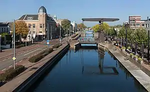
Helmond has many textile companies. The Vlisco factory is located next to the Zuid-Willemsvaart canal which runs through the city.[5]
The name 'Helmond' can be traced back to a combination of Hel, which means "low-lying" (from Proto-Germanic *haljæ / contemporary Hel), and Mond, which would refer to a higher ground, secure place. The name has nothing to do with the contemporary literal translation of Hell Mouth.[6] In 1241 a first coat of arms was created, containing a helmet as a reference to the word Helmond, since this early in history the historical meaning of the city name was already lost to its inhabitants. This helmet would symbolize the fortified medieval town. Originally a medieval pot helmet, this was later adapted to a new fashion style and is now a tournament helmet. The oak branches symbolizing freedom. The bird in the branches is a medieval decoration and has no meaning.
The spoken language is Helmonds (an East Brabantian dialect).[7]
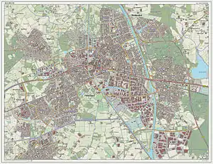
Geography
Helmond is subdivided into quarters and neighbourhoods:[8]
- Quarter 11 Inner City
- Neighbourhood 0 Centrum
- Neighbourhood 2 Leonardus
- Neighbourhood 3 Heipoort
- Neighbourhood 4 Stationsgebied
- Neighbourhood 5 Vossenberg
- Neighbourhood 6 Annabuurt en Suytkade
- Neighbourhood 7 Steenweg en omgeving
- Quarter 11 Helmond-East
- Neighbourhood 0 Beisterveld
- Neighbourhood 1 Beisterveldse Broek
- Neighbourhood 2 Straakven
- Quarter 12 Helmond-North
- Neighbourhood 0 Bloemvelden
- Neighbourhood 1 Binderen
- Neighbourhood 2 Eeuwsels
- Quarter 13 Mierlo-Hout
- Neighbourhood 0 't Hout-Centrum
- Neighbourhood 1 Kroon
- Neighbourhood 2 Akkers
- Neighbourhood 3 Gansenwinkel
- Neighbourhood 9 Groot Goor
- Quarter 14 Brouwhuis
- Neighbourhood 0 Brouwhuis-Dorp
- Neighbourhood 1 Brouwhuis-West
- Neighbourhood 2 Brouwhuis-Oost
- Neighbourhood 4 Brouwhorst
- Neighbourhood 9 Kloostereind
- Quarter 15 Helmond-West
- Neighbourhood 0 West
- Neighbourhood 1 Houtsdonk
- Quarter 16 Warande
- Neighbourhood 0 Oranjebuurt
- Neighbourhood 1 Zwanenbeemd
- Neighbourhood 9 Overbrug
- Quarter 17 Stiphout
- Neighbourhood 0 Stiphout-Dorp
- Neighbourhood 1 Schooten
- Neighbourhood 9 Geeneind
- Quarter 18 Rijpelberg
- Neighbourhood 1 Rijpelberg-Oost
- Neighbourhood 2 Rijpelberg-West
- Neighbourhood 9 Berkendonk
- Quarter 19 Dierdonk
- Neighbourhood 0 Kern Dierdonk
- Neighbourhood 9 Scheepstal
- Quarter 21 Brandevoort
- Neighbourhood 1 De Veste
- Neighbourhood 2 Schutsboom
- Neighbourhood 3 Stepekolk
- Neighbourhood 4 Berenbroek
- Quarter 29 Industrial park-South
- Neighbourhood 1 Hoogeind
- Neighbourhood 2 B.Z.O.B.
History
First settlements in the area were around 1000, and Helmond was granted city rights in approximately 1232. Helmond Castle is located at the center of the city. It was built by Jan III van Berlaer around 1350.
Transport
Railway stations: Helmond, Helmond Brouwhuis, Helmond Brandevoort, Helmond 't Hout
Local media
Newspapers:
- ED - Helmond Plus
- ZondagNieuws (translated: SundayNews)
- De Traverse
- De Loop
Radio:
- Omroep Helmond (Radio) (translated: Helmond Broadcasting (Radio))
- Internetradio Helmond Sport
Television:
- Omroep Helmond (TV) (translated: Helmond Broadcasting (TV)
News on the internet:
- Alles Over Helmond (part of Omroep Helmond) (translated: Everything About Helmond)
- De Weblog van Helmond (translated: Helmonds´ weblog)
Politics
Municipal council
The municipal council consists of 37 seats. Below the council since 1998:
| Seats | |||||||||||||||
|---|---|---|---|---|---|---|---|---|---|---|---|---|---|---|---|
| Partij | 1998 | 2002 | 2006 | 2010 | 2014 | 2018 | |||||||||
| SDOH-D66-HB* | - | - | - | 8 | - | - | |||||||||
| CDA | 8 | 7 | 8 | 7 | 6 | 5 | |||||||||
| PvdA | 7 | 5 | 9 | 6 | 3 | 2 | |||||||||
| VVD | 4 | 5 | 4 | 5 | 5 | 5 | |||||||||
| Helder Helmond | - | - | 2 | 3 | 1 | 3 | |||||||||
| SP | 3 | 3 | 4 | 3 | 6 | 5 | |||||||||
| GroenLinks | 2 | 1 | 1 | 2 | 2 | 6 | |||||||||
| Trots op Nederland | - | - | - | 2 | - | - | |||||||||
| Helmond Aktief | - | 1 | 1 | 1 | 2 | 1 | |||||||||
| 50Plus | 2 | 3 | 1 | - | 2 | 3 | |||||||||
| D66 | 1 | 1 | 1 | -* | 3 | 3 | |||||||||
| Helmondse Belangen | 2 | 5 | 2 | -* | - | - | |||||||||
| SDH-OH | 6 | 6 | 4 | -* | - | - | |||||||||
| Lokaal sterk | - | - | - | - | 6 | 3 | |||||||||
| Plan! | - | - | - | - | 1 | 1 | |||||||||
| Total | 35 | 37 | 37 | 37 | 37 | 37 | |||||||||
- The political parties SDH-OH, Helmondse Belangen, and D66 form 1 parliamentary group in the council, but took part in the elections separately. In the elections they received 4, 2 and 2 seats respectively.
- The party 50Plus was known as senioren until the elections of 2018
Representatives of the blue colored parliamentary groups form the executive coalition.
Notable residents
%252C_1572.jpg.webp)


- Lucas Gassel (ca.1490-ca.1570) Flemish Renaissance painter of landscapes
- Anthonius Konings (1821-1884) a Redemptorist professor and theological writer [9]
- Theodorus Willem van Lidth de Jeude (1853–1937) a Dutch zoologist and herpetologist
- Matthijs Vermeulen (1888–1967) a Dutch composer and music journalist
- Willem Zeylmans van Emmichoven (1893-1961) a Dutch psychiatrist and anthroposophist
- Franz Jozef Van Beeck (1930-2011) a Dutch priest, author and Christian theologian
- Elly Blanksma-van den Heuvel (born 1959), politician and former bank manager, Mayor of Helmond since 2012
- Harry van Bommel (born 1962) a politician, anti-globalisation activist and former educator
- Diana van Berlo (born 1966), former member of disco/pop girl group Luv'
- Stochelo Rosenberg (born 1968) a Gypsy jazz guitarist who leads the Rosenberg Trio
- M. H. Benders (born 1971) a Dutch poet and philosopher
Sport
- Willy van der Kuijlen (born 1946) a former Dutch football player with 545 club caps
- Lisette Sevens (born 1949) field hockey player, team gold medallist at the 1984 Summer Olympics
- René and Willy van de Kerkhof (born 1951), twins, former footballers with 491 & 511 club caps
- Fieke Boekhorst (born 1957) field hockey player, team gold medallist at the 1984 Summer Olympics
- Berry van Aerle (born 1962) a Dutch retired footballer with 315 club caps
- Hans Gillhaus (born 1963) a Dutch retired footballer with 400 club caps
- Pieter Gruijters (born 1967) is a Paralympic athlete,
- Wilfred Bouma (born 1978) a Dutch former footballer with 411 club caps
- Nieky Holzken (born 1983) a Dutch super middleweight kickboxer and professional boxer
- Bob de Voogd (born 1988) a Dutch field hockey player, team silver medallist at the 2012 Summer Olympics
Twin towns — sister cities
- Helmond is a member city of Eurotowns network[10]
Helmond is twinned with:
|
|
Gallery
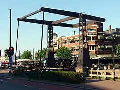 Bridge over Zuid-Willemsvaart in Helmond
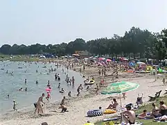 Berkendonkbijdrukte
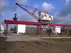 Monumentale loskraan Slits Helmond Kanaalduik zuid
 Helmond Der Tanz Dasha Stransky
References
- "Mw. Elly Blanksma- Van den Heuvel" (in Dutch). Gemeente Helmond. Retrieved 28 May 2014.
- "Kerncijfers wijken en buurten 2020" [Key figures for neighbourhoods 2020]. StatLine (in Dutch). CBS. 24 July 2020. Retrieved 19 September 2020.
- "Postcodetool for 5707BX". Actueel Hoogtebestand Nederland (in Dutch). Het Waterschapshuis. Archived from the original on 21 September 2013. Retrieved 28 May 2014.
- "Bevolkingsontwikkeling; regio per maand" [Population growth; regions per month]. CBS Statline (in Dutch). CBS. 1 January 2019. Retrieved 1 January 2019.
- Vlisco Véritable Hollandais
- Onder de Biesbosch, Historisch-geografische en naamkundige bouwstenen voor een reconstructie van het in 1421 verdronken middeleeuwse cultuurlandschap van de Groote Waard. Tijdschrift voor Waterstaatsgeschiedenis (2006); webversie 2007. (PDF) In Dutch. Retrieved 11 March 2015.
- Jos & Cor Swanenberg: Taal in stad en land: Oost-Brabants, ISBN 9012090105
- "CBS StatLine - Kerncijfers wijken en buurten 2004-2010". Statline.cbs.nl. Retrieved 2011-09-16.
- Catholic Encyclopedia, Volume 8 (1913), Anthony Konings, retrieved 24 February 2020
- "Eurotowns".
- "Zielona Góra Miasta partnerskie". Urząd Miasta Zielona Góra. Retrieved 2013-06-24.
External links
- Official Website (in Dutch)
 Helmond travel guide from Wikivoyage
 Media related to Helmond at Wikimedia Commons
- . Encyclopædia Britannica (11th ed.). 1911.
Places adjacent to Helmond | |
|---|---|

| Authority control |
|---|