Šalčininkai District Municipality
Šalčininkai District Municipality (Lithuanian: Šalčininkų rajono savivaldybė; Polish: Samorząd rejonu solecznickiego) is one of 60 municipalities in Lithuania. It has one of biggest Polish minority populations in Lithuania, with 31,821 or 77,75% (2011 census) of the population claiming Polish ethnicity.[1] Šalčininkai is the largest town and the administrative center of the district with its newly built quarters, while the second largest town is Eišiškės, more historical town, which was the center of the district and the largest town before 1972.
Šalčininkai District Municipality
Šalčininkų rajono savivaldybė Samorząd rejonu solecznickiego | |
|---|---|
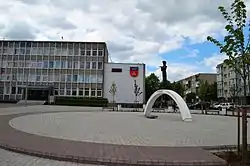 City centre of Šalčininkai | |
 Coat of arms | |
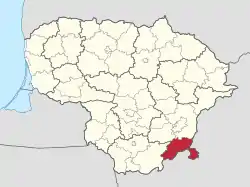 Location of Šalčininkai District Municipality | |
| Country | |
| Ethnographic region | Dzūkija |
| County | |
| Capital | Šalčininkai |
| Elderships | List
|
| Area | |
| • Total | 1,491 km2 (576 sq mi) |
| Population (2020 estimate) | |
| • Total | 30,520 |
| • Density | 20/km2 (53/sq mi) |
| Time zone | UTC+2 (EET) |
| • Summer (DST) | UTC+3 (EEST) |
| Website | www |
The south-eastern border of the municipality with Belarus includes a distinctive salient of Lithuanian territory, known as the Dieveniškės appendix, almost completely surrounded by Belarus.
Lithuanian Route 104 passes through the district.
The Poškonys Reservoir (Poškonių tvenkinys) with an area of 0.3 km2 on the Gauja River is located in the district.
References