1872 Atlantic hurricane season
The 1872 Atlantic hurricane season was quiet, lasting from mid-summer through mid-autumn. There were five tropical cyclones, of which four attained hurricane status. However, in the absence of modern satellite and other remote-sensing technologies, only storms that affected populated land areas or encountered ships at sea were recorded, so the actual total could be higher. An undercount bias of zero to six tropical cyclones per year between 1851 and 1885 and zero to four per year between 1886 and 1910 has been estimated.[1] Of the known 1872 cyclones, significant changes were made to the tracks of Hurricane Two and Hurricane Four in 1995 by Jose Fernandez-Partagas and Henry Diaz, who also proposed smaller changes to the known track of Hurricane Three.[2] Further analysis, in 2003, revised the track of Hurricane Five.[3]
| 1872 Atlantic hurricane season | |
|---|---|
 Season summary map | |
| Seasonal boundaries | |
| First system formed | July 9, 1872 |
| Last system dissipated | October 28, 1872 |
| Strongest storm | |
| Name | Two |
| • Maximum winds | 105 mph (165 km/h) (1-minute sustained) |
| Seasonal statistics | |
| Total storms | 5 |
| Total fatalities | 0 |
| Total damage | Unknown |
Season summary

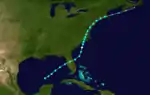
The Atlantic hurricane database (HURDAT) recognizes five tropical cyclones for the 1872 season. Four storms attained hurricane status, with winds of 75 mph (119 km/h) or greater. Only two of the systems directly impacted land. The second hurricane of the season, was the most intense, with maximum sustained winds up to 100 mph (170 km/h). The first storm of the season was a tropical storm that developed in the Gulf of Mexico on July 9 and made landfall along the US Gulf coast before dissipating over Tennessee. Hurricane Two, the strongest storm of the season, traveled across the Atlantic from Cape Verde to Newfoundland between August 20 and September 1. Hurricane Three grew from a tropical storm that formed east of the Lesser Antilles. It traveled north and developed into a hurricane, but never made landfall and was last observed on September 19. Hurricane Four also never made landfall. Growing from a tropical storm first seen south-west of the Cape Verde Islands, it traveled across the Atlantic and was last seen near the Azores on October 6. The final storm of the season began as a tropical storm in the Gulf of Mexico on October 22. It crossed the Florida peninsula and hit South Carolina as a category 1 hurricane. It was last sighted on October 27.
Systems
Tropical Storm One
| Tropical storm (SSHWS) | |
  | |
| Duration | July 9 – July 13 |
|---|---|
| Peak intensity | 60 mph (95 km/h) (1-min) |
Tropical Storm One formed in the central Gulf of Mexico on July 9. Tropical Storm One struck Louisiana and Mississippi before being last seen over Tennessee on July 13.[4]
Hurricane Two
| Category 2 hurricane (SSHWS) | |
  | |
| Duration | August 20 – September 1 |
|---|---|
| Peak intensity | 105 mph (165 km/h) (1-min) |
Hurricane Two formed near Cape Verde on August 20. Hurricane Two headed across the Atlantic but then curved north and passed near Bermuda. Hurricane Two persisted until it was last seen near Newfoundland on September 2.[4]
Hurricane Three
| Category 1 hurricane (SSHWS) | |
 | |
| Duration | September 9 – September 20 |
|---|---|
| Peak intensity | 80 mph (130 km/h) (1-min) |
On September 9, a tropical storm was observed east of the Lesser Antilles. Over the following two days, it moved slowly north-northwestward through the islands, before reaching hurricane status on September 12. It turned more toward the north, and passed east of Bermuda on September 15. It was last observed on September 19.[4]
Hurricane Four
| Category 1 hurricane (SSHWS) | |
 | |
| Duration | September 30 – October 6 |
|---|---|
| Peak intensity | 80 mph (130 km/h) (1-min) |
A tropical storm formed on September 30 to the southwest of the Cape Verde islands. It tracked northwestward for several days, reaching hurricane status on October 3. Two days later it curved to the northeast, and the hurricane was last observed on October 6 near the Azores.[4]
Hurricane Five
| Category 1 hurricane (SSHWS) | |
  | |
| Duration | October 22 – October 27 |
|---|---|
| Peak intensity | 80 mph (130 km/h) (1-min) |
In the southern Gulf of Mexico, a tropical storm developed on October 22. It crossed Florida from Cedar Key to Jacksonville[5] as a 60 mph (97 km/h) tropical storm, and hit South Carolina as a minimal hurricane.[4] It caused 4-8 inches of rain in the Norfolk area.[6]
See also
References
- Landsea, C. W. (2004). "The Atlantic hurricane database re-analysis project: Documentation for the 1851–1910 alterations and additions to the HURDAT database". In Murname, R. J.; Liu, K.-B. (eds.). Hurricanes and Typhoons: Past, Present and Future. New York: Columbia University Press. pp. 177–221. ISBN 0-231-12388-4.
- Partagas, J.F. and H.F. Diaz, 1995b "A Reconstruction of Historical Tropical Cyclone Frequency in the Atlantic from Documentary and other Historical Sources : 1851-1880 Part II: 1871-1880" Climate Diagnostics Center, NOAA, Boulder, CO
- Hurricane Research Division (2008). "Documentation of Atlantic Tropical Cyclones Changes in HURDAT". National Oceanic and Atmospheric Administration. Retrieved 2011-03-14.
- Hurricane Research Division (2008). "Easy to Read HURDAT". National Oceanic and Atmospheric Administration. Retrieved January 23, 2010.
- Al Sandrik & Chris Landsea (2003). "Chronological Listing of Tropical Cyclones affecting North Florida and Coastal Georgia 1565-1899". Hurricane Research Division. Archived from the original on 6 December 2006. Retrieved 2007-01-02.
- David Roth & Hugh Cobb. "Virginia Hurricane History". National Oceanic and Atmospheric Administration. Archived from the original on January 8, 2008. Retrieved January 14, 2008.