1978 Sri Lanka cyclone
The 1978 Sri Lanka Cyclone (JTWC designation: 04B) was the strongest tropical cyclone to strike Sri Lanka's Eastern province since modern records began.[1] The cyclone formed on November 20, 1978 and attained peak intensity on November 23, 1978 right before making landfall on Trincomalee. In Sri Lanka's Eastern Province, Akkaraipattu, Kalmunai, Chettipalayam, Kattankudy, Batticaloa, Eravur and Kalkudah were the most affected due to their position in the vicinity of the cyclone.[2]
| Very severe cyclonic storm (IMD scale) | |
|---|---|
| Category 3 tropical cyclone (SSHWS) | |
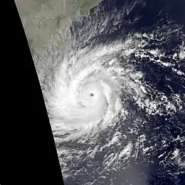 Cyclone 04B at peak intensity | |
| Formed | November 19, 1978 |
| Dissipated | November 29, 1978 |
| Highest winds | 3-minute sustained: 140 km/h (85 mph) 1-minute sustained: 205 km/h (125 mph) |
| Lowest pressure | 953 hPa (mbar); 28.14 inHg |
| Fatalities | ~1000 |
| Areas affected | Eastern Province, Sri Lanka |
| Part of the 1978 North Indian Ocean cyclone season | |
Impact
Due to the cyclone, approximately 915 people died, more than one million people affected, nearly 250,000 houses partially and completely damaged, 240 school buildings damaged, one fifth of Batticaloa's fishing fleet destroyed, 9 of the 11 paddy stores destroyed and 90 percent of the coconut plantation (28,000 odd acres of coconut plantation) in the Batticaloa district destroyed. The Sri Lankan government spent over 600 million Sri Lankan rupees in relief efforts in the aftermath of the disaster. A tropical cyclone report noted that over 130 electrical lines were downed and copious amounts of religious buildings were reduced to rubble. The cyclone resulted in people being left without electricity and water. Many houses suffered severe structural damage due to the excessive speed of the cyclone.[3][4]
In India, the storm brought minimal damages to Tamilnadu. In Ramanathapuram and Tuticorin districts nearly 5000 huts were damaged and damages in Indian Rupees were estimated to be 5 crores. Also the storm brought minimal rainfall over Kerala and Lakshadweep Islands
Meteorological history
The storm formed on 19 November over Southwest Bay of Bengal. It intensified gradually upto Very Severe Cyclonic Storm and high end Category 3 equivalent cyclone on 23 November with windspeed of 140 kmph and 205 kmph respectively. With the same peak intensity, the storm made landfall over Sri Lanka at Batticaloa with gusts upto 150 kmph. It emerged over the Gulf of Mannar on 24th and at the same evening, the storm made second landfall over Kilakkarai in Tamilnadu as a weakened Severe Cyclonic Storm. The storm re-emerged off Kerala coast. Then the storm spent remaining days over Arabian Sea and dissipated on 29 November off Gujarat coast.
References
- "Disaster Profile - Sri Lanka". Retrieved 10 May 2014.
- Neelavannan (1979). 12 மணி நேரம் (The 12 hours). Jaffna, Sri Lanka. p. 29.
- "Disaster Information Management system in Sri Lanka". www.desinventar.lk.
- "Batticaloa's blackest day". Archived from the original on 2015-09-24. Retrieved 2013-12-05.