2001 India cyclone
The 2001 India cyclone was the third strongest tropical cyclone, in terms of barometric pressure, to form in the Arabian Sea on record; only Cyclones Gonu in 2007 and Kyarr in 2019 were stronger. The storm originated from a tropical disturbance that formed east of Somalia on May 18. Over the following few days, the system gradually organized into a tropical depression. Tracking eastward, towards the coastline of southwestern India, the storm slowly intensified. Shortly before reaching shore, the system turned north and later west, away from land. After taking this turn, the storm intensified into a very severe cyclonic storm, attaining its peak intensity on May 24 with winds of 215 km/h (130 mph 3-minute winds) and a barometric pressure of 932 mbar (hPa). At the time, this ranked the cyclone as the strongest known storm in the Arabian Sea.
| Extremely severe cyclonic storm (IMD scale) | |
|---|---|
| Category 3 tropical cyclone (SSHWS) | |
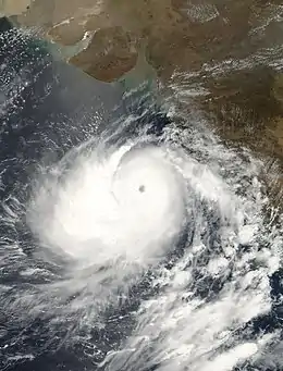
 The cyclone shortly before peak intensity on May 23 | |
| Formed | May 21, 2001 |
| Dissipated | May 29, 2001 |
| Highest winds | 3-minute sustained: 215 km/h (130 mph) 1-minute sustained: 205 km/h (125 mph) |
| Lowest pressure | 932 hPa (mbar); 27.52 inHg |
| Fatalities | 120–900 dead or missing[1] |
| Damage | Minimal |
| Areas affected | Western India |
| Part of the 2001 North Indian Ocean cyclone season | |
After stalling several hundred kilometres offshore, the storm weakened over cooler waters that it had upwelled. By May 27, the system weakened to a cyclonic storm and by this time was approaching the northwestern coastline of India, near Gujarat. The following day, the storm made landfall in the Saurashtra region as a deep depression with winds of 55 km/h (35 mph 3-minute winds). The depression quickly weakened after moving inland and dissipated early on May 29.
Although a powerful cyclone over water, the storm had relatively little impact over land. In the Valsad district, two coastal communities lost a combined 200 homes due to large swells produced by the storm. However, the losses were more extensive offshore. Between 120 and 900 fishermen were listed as missing after contact was lost with their vessels during the storm.
Meteorological history

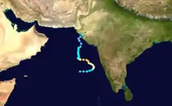
The origins of the 2001 India cyclone can be traced to a tropical disturbance over the Arabian Sea on May 18. The following day, the system was determined to be relatively stationary near the island of Socotra. Although deep convection was associated with the disturbance, there was no evidence of a low-level circulation. By May 20, the disturbance slowly moved towards the southeast in response to an upper-level trough over India. The overall structure gradually improved as good outflow developed. A mid-level circulation finally developed late on May 21, prompting the Joint Typhoon Warning Center (JTWC) to issue a Tropical Cyclone Formation Alert.[1] Several hours later, they began monitoring the system as a tropical depression with the identifier 01A;[2] however, operational advisories were not issued until the cyclone was estimated to have attained tropical storm intensity.[1][2] By the morning of May 22, the India Meteorological Department (IMD) also took notice of the system.[1]
Situated in a region favoring tropical cyclone development about 650 km (400 mi) southwest of Mumbai, India, the storm rapidly developed.[1] By the afternoon of May 22, the JTWC estimated that 01A attained winds of 120 km/h (75 mph), equivalent to a Category 1 hurricane on the Saffir–Simpson Hurricane Scale.[2] Additionally, a 22 km (14 mi) wide eye developed within the center of circulation during this intensification phase. Throughout most of May 22, the strengthening slowed considerably as it paralleled the southwestern coast of India. Initially, it was feared that the storm would move inland as a powerful cyclone; however, a ridge over the northern Arabian Sea caused the storm to turn westward, back over open water. Once further away from land, the cyclone resumed intensification, becoming a rare, Category 3 equivalent storm by the morning of May 24.[1] Later that morning, 01A attained its peak intensity with winds of 205 km/h (125 mph), according to the JTWC.[2] However, the IMD considered the storm to be slightly stronger, estimating that it attained winds of 215 km/h (130 mph) by three-minute sustained winds along with a barometric pressure of 932 mbar (hPa; 27.52 inHg).[3]
At the time of peak intensity, the cyclone displayed a well-defined eye and excellent outflow. Although a powerful storm, it quickly weakened as conditions became hostile for tropical cyclone development. Strong wind shear tore convection away from the cyclone and caused it to become disorganized. Within 48 hours, the system had degraded to a tropical storm and was situated roughly 555 km (345 mi) west-southwest of Mumbai. The weakening trend lessened shortly thereafter but still continued. Operationally, the JTWC issued their final advisory on the cyclone on May 28 as it weakened to a tropical depression over open waters. The once powerful cyclone, now devoid of all convection, tracked towards the northwestern coast of India.[1] During the afternoon of May 29, the cyclone rapidly regenerated as it made landfall in Gujarat. The JTWC estimated that it crossed the coastline with winds of 100 km/h (65 mph). Not long after moving overland, the system rapidly weakened and dissipated over India within several hours.[2]
Preparations and impact
Ahead of the storm, all ports in Gujarat, including Kandla, one of the largest in the country, were closed as a precautionary measure.[4] On May 25, over 10,000 people were evacuated from coastal areas in the threatened region.[5] Throughout India, a total of 118,800 people were evacuated[1] and 100,000 more were evacuated in Pakistan.[6] The Indian military was placed on standby to undertake search-and-rescue missions immediately after the storms' passage. Fourteen districts of Gujarat were placed on red alert, the highest level of preparedness. Seven emergency control centers were set up across the country and officials alerted hospitals and fire crews about the approaching storm.[7]
Several relief agencies were already positioned in the region in response to a magnitude 6.9 earthquake in January of that year that killed over 20,000 people.[8] Additional disaster relief teams were deployed to the region to further prepare residents for the cyclone. Food, water and other necessities were stored and ready to be provided to victims of the storm.[9] Large swells produced by the storm affected a large portion of the western Indian coastline, especially in the city of Bombay.[10] In the Valsad district, two coastal communities lost a combined 200 homes due to large swells produced by the storm.[1] Offshore, between 1,500 and 2,000 fishing vessels had lost contact with the mainland.[5] Later reports indicated that between 120 and 900 fishermen had gone missing as a result of the cyclone.[1]
Records
Operationally, the cyclone was considered to be a Category 4 equivalent storm by the JTWC, with peak winds of 215 km/h (130 mph).[11] This would have made the system the first recorded storm of that intensity on record in the Arabian Sea.[12] However, in post-storm analysis, it was discovered that 1-minute winds did not exceed 205 km/h (125 mph).[13] The next storm to reach this intensity was Cyclone Gonu in 2007 North Indian Ocean cyclone season, which became the first known super cyclonic storm in the region.[3][14] Upon attaining its peak intensity, the storm attained a barometric pressure of 932 mbar (hPa), the lowest in the region at the time. The cyclone was ranked as the strongest in the Arabian Sea for six years until it was surpassed by Gonu in 2007, which attained a minimum pressure of 920 mbar (hPa).[3] In 2010, Cyclone Phet surpassed the 2001 cyclone as the second-strongest storm in the region, attaining winds of 230 km/h (145 mph), according to the JTWC. Again it was surpassed to fifth place as Cyclone Kyarr, Cyclone Chapala and Cyclone Nilofar surpassed it's windspeed intensity as they become category 4 tropical cyclones in latter years. Now this cyclone is tied with Cyclone Megh for fifth strongest cyclone in Arabian Sea based on windspeed of one minute mean. [15]
See also
References
- Gary Padgett (July 10, 2001). "Monthly Tropical Weather Summary for May 2001". Typhoon2000. Retrieved December 13, 2009.
- Joint Typhoon Warning Center (2002). "Cyclone 01A Best Track". Naval Meteorology and Oceanography Command. Retrieved June 3, 2010.
- "IMD Best Tracks Data ( 1990–2008 )". India Meteorological Department. 2009. Archived from the original on November 16, 2009. Retrieved December 13, 2009.
- Reuters (May 26, 2001). "India cyclone weakening but still 'a threat'". CNN. Retrieved December 13, 2009.
- Reuters (May 25, 2001). "Cyclone threatens India, Pakistan". CNN. Retrieved December 13, 2009.
- Agence France-Presse (May 29, 2001). "100,000 Pakistanis who fled storm to return home". ReliefWeb. Retrieved December 13, 2009.
- Vikram Vakil (May 24, 2001). "Gujarat govt geared up to face cyclone". Rediff. Retrieved December 13, 2009.
- Associated Press (May 27, 2001). "India's quake-hit Gujarat braces as giant cyclone gathers strength". ReliefWeb. Retrieved December 13, 2009.
- International Federation of Red Cross And Red Crescent Societies (May 25, 2001). "India: Cyclone Information Bulletin No. 1". ReliefWeb. Retrieved December 13, 2009.
- Staff Writer (May 26, 2001). "Cyclone Rips Into Bombay". The Record. p. D.21. Retrieved December 13, 2009.
- Gary Padgett (June 11, 2001). "Monthly Tropical Cyclone Tracks for May 2001". Typhoon2000. Retrieved December 13, 2009.
- Joint Typhoon Warning Center (2009). "JTWC North Indian Ocean Best Tracks 1945–2008". Naval Meteorology and Oceanography Command. Archived from the original on 2010-03-01. Retrieved December 13, 2009.
- Joint Typhoon Warning Center (2002). "2001 Annual Tropical Cyclone Report" (PDF). Naval Meteorology and Oceanography Command. Archived from the original (PDF) on 2011-06-06. Retrieved December 13, 2009.
- Joint Typhoon Warning Center (2008). "JTWC Best Track for Tropical Cyclone 02A (Gonu)". Naval Meteorology and Oceanography Command. Retrieved December 13, 2009.
- Joint Typhoon Warning Center (June 2, 2010). "Cyclone Phet (03A) Advisory Number Eight". Naval Meteorology and Oceanography Command. Archived from the original on June 2, 2010. Retrieved June 3, 2010.
