2019 North Indian Ocean cyclone season
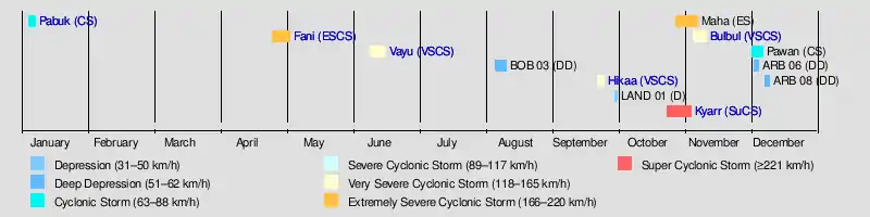
The 2019 North Indian Ocean cyclone season was the most active North Indian Ocean cyclone season ever recorded in terms of cyclonic storms, though the 1992 season saw more tropical storms according to the Joint Typhoon Warning Center. The season featured 12 depressions, 11 deep depressions, 8 cyclonic storms, a record 6 severe cyclonic storms, a record 6 very severe cyclonic storms, a record 3 extremely severe cyclonic storms, and 1 super cyclonic storm, Kyarr, the first since Cyclone Gonu in 2007. Additionally, it was also the third-costliest season recorded in the North Indian Ocean, only behind the 2020 and 2008 seasons.
| 2019 North Indian Ocean cyclone season | |
|---|---|
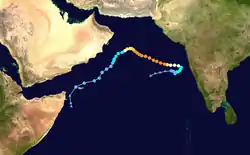
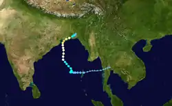
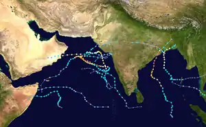 Season summary map | |
| Seasonal boundaries | |
| First system formed | January 4, 2019 (record earliest, tied with 2014) |
| Last system dissipated | December 10, 2019 |
| Strongest storm | |
| Name | Kyarr |
| • Maximum winds | 240 km/h (150 mph) (3-minute sustained) |
| • Lowest pressure | 922 hPa (mbar) |
| Seasonal statistics | |
| Depressions | 12 |
| Deep depressions | 11 |
| Cyclonic storms | 8 |
| Severe cyclonic storms | 6 |
| Very severe cyclonic storms | 6 (record high) |
| Extremely severe cyclonic storms | 3 (record high) |
| Super cyclonic storms | 1 |
| Total fatalities | 177 total |
| Total damage | > $11.5 billion (2019 USD) (Third-costliest North Indian Ocean cyclone season on record) |
| Related articles | |
The season's first named storm, Pabuk, entered the basin on January 4, becoming the earliest-forming cyclonic storm of the North Indian Ocean on record. The second cyclone of the season, Cyclone Fani, was the strongest tropical cyclone in the Bay of Bengal by 3-minute maximum sustained wind speed and minimum barometric pressure since the 1999 Odisha cyclone, while being equal in terms of maximum 3-minute sustained wind speed to 2007's Sidr and 2013's Phailin. Further activity occurred in October, and in the latter part of that month, the first Super Cyclonic Storm of the 2010s, Kyarr, formed.
The scope of this article is limited to the Indian Ocean in the Northern Hemisphere, east of the Horn of Africa and west of the Malay Peninsula. There are two main seas in the North Indian Ocean — the Arabian Sea to the west of the Indian subcontinent, abbreviated ARB by the India Meteorological Department (IMD); and the Bay of Bengal to the east, abbreviated BOB by the IMD.
The official Regional Specialized Meteorological Centre in this basin is the India Meteorological Department (IMD), while the Joint Typhoon Warning Center (JTWC) and the National Meteorological Center of CMA (NMC) unofficially release full advisories. On average, three to four cyclonic storms form in this basin every season.[1][2]
Season summary
The season had eight cyclonic storms, six very severe cyclonic storms and one super cyclonic storm, becoming exceptionally active. Amid a weak El Niño event, the season's first named storm, Pabuk, entered the basin on January 4, becoming the earliest-forming cyclonic storm of the North Indian Ocean on record, tying with the 2014 season. The second cyclonic storm of the season, Fani, formed on April 26. Fani became an extremely severe cyclonic storm on April 30, reaching the equivalent of Category 5 status on the Saffir-Simpson scale, then made landfall in India killing 89 people between Odisha and Bangladesh; Fani caused $8.1 billion in damage.
In early June, a strong pulse of the Madden-Julian Oscillation (MJO) led to the development of the third cyclonic storm, Vayu, which formed June 10 in the Arabian Sea near the Maldives. The storm subsequently intensified into a very severe cyclonic storm on June 12, after moving northwestward towards northwestern India and Pakistan. No tropical cyclones formed in the month of July. Deep Depression BOB 03 formed on August 7 before impacting East India and Bangladesh. In late September, Deep Depression ARB 02 formed near Gujarat and intensified into the fourth cyclonic storm of the season, Hikaa. Cyclonic Storm Kyarr formed on October 24 and three days later became the first super cyclonic storm since Cyclone Gonu in 2007. The sixth cyclonic storm and a record-breaking fifth very severe cyclonic storm, Cyclone Maha, formed on October 30 after Kyarr dissipated on November 1. Soon after, on 6th November the remnants of Severe Tropical Storm Matmo crossed the Southeast Asia overland and again consolidated into a depression. It further rapidly intensified to very severe Cyclone Bulbul. Three more Deep Depressions formed in Arabian Sea in quick succession early in the month of December, out of which, one strengthened into the eighth cyclone of the season, Cyclone Pawan, which made landfall in Somalia on December 6.
The high amount of activity in the Arabian Sea was related to the strongest Indian Ocean Dipole in 60 years, in which the waters are warmer in the western Indian Ocean than the eastern.[3]
Tropical cyclones have been recorded in the North Indian Ocean since 1891. The 2019 season was the first since 1902 that experienced the development of six severe cyclonic storms out of eight cyclonic storms; in 1902, five cyclonic storms formed and four of them became severe cyclonic storms.[4] The season has also produced the most accumulated cyclone energy in this basin on record.
Systems
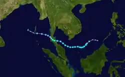
Cyclonic Storm Pabuk
| Cyclonic storm (IMD) | |
| Tropical storm (SSHWS) | |
  | |
| Duration | January 4 (Entered basin) – January 7 |
|---|---|
| Peak intensity | 85 km/h (50 mph) (3-min) 998 hPa (mbar) |
Originally a tropical storm that formed over the South China Sea on January 1, Pabuk entered the Gulf of Thailand. Shortly afterward, Pabuk made landfall over southern Thailand on January 4 and crossed into the Andaman Sea. The IMD then initiated advisories on the storm, making Pabuk the earliest-forming cyclonic storm for this basin, surpassing Hibaru in 2005, as well as the first cyclonic storm with a name originally assigned by RSMC Tokyo.[5] Over the next few days, Pabuk continued moving west-northwestward, before weakening into a well-marked low on January 7. The system's remnant low then turned to the northeast, subsequently dissipating on January 8.
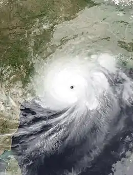
Extremely Severe Cyclonic Storm Fani
| Extremely severe cyclonic storm (IMD) | |
| Category 5 tropical cyclone (SSHWS) | |
 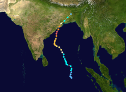 | |
| Duration | April 26 – May 4 |
|---|---|
| Peak intensity | 215 km/h (130 mph) (3-min) 932 hPa (mbar) |
On April 26, a depression formed to the west of Sumatra, with the IMD giving the storm the identifier BOB 02. The system slowly organized while curving towards the northeast. On April 27, at 00:00 UTC, the IMD upgraded the system to a deep depression.[6] Later that day, the system intensified into Cyclonic Storm Fani, while shifting to the northwest. Development of the system proceeded very slowly for several days, with the cyclone struggling to intensify against the influence of moderate vertical wind shear.[7] At 12:00 UTC on 29 April, Fani was upgraded to a severe cyclonic storm, with the system beginning to undergo rapid intensification.[8][9] Fani continued rapidly intensifying, becoming an extremely severe cyclonic storm at 17:00 UTC on April 30.[10] The Joint Typhoon Warning Center (JTWC) upgraded the system to a Category 4 tropical cyclone on the Saffir–Simpson scale at 06:00 UTC on May 2, following which, rapid intensification resumed. The pressure decreased to 932 hPa (27.52 inHg),[11] three-minute sustained winds increased to 215 km/h (130 mph), and one-minute sustained winds to 280 km/h (175 mph), making the system the equivalent of a Category 5 major hurricane.[12] On May 3, at 02:30 UTC (8:00 a.m. IST) Fani made landfall on Puri, in Odisha,[13][14] weakening to a Category 1-equivalent very severe cyclonic storm soon after landfall, subsequently weakening to a cyclonic storm several hours later.[15] On May 4, Fani weakened into a deep depression and moved into Bangladesh.[16] Later that day, Fani degenerated into a well-marked low,[17] before dissipating on the next day.
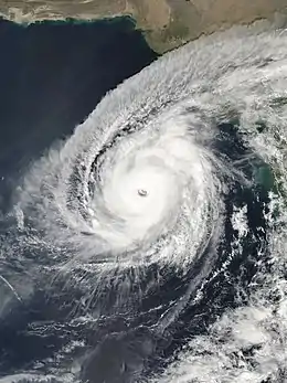
Very Severe Cyclonic Storm Vayu
| Very severe cyclonic storm (IMD) | |
| Category 3 tropical cyclone (SSHWS) | |
.jpg.webp) 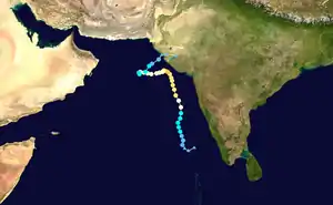 | |
| Duration | June 10 – June 17 |
|---|---|
| Peak intensity | 150 km/h (90 mph) (3-min) 970 hPa (mbar) |
In early June, a strong pulse of the Madden-Julian Oscillation (MJO) tracked eastwards into the tropical Indian Ocean, leading to increased cloudiness and rainfall across the region.[18] On June 9, the India Meteorological Department (IMD) noted the development of a low-pressure area over the southeastern Arabian Sea, to the north of the Maldives. Early on June 10, a depression formed in the Arabian Sea, just northwest of the Maldives, and the IMD gave the storm the identifier ARB 01. As the system moved northward, it gradually strengthened, becoming a deep depression, before intensifying further into Cyclonic Storm Vayu later that day. After being upgraded by the IMD to a severe cyclonic storm on June 11, and concurrently by the JTWC to a Category 1 tropical cyclone on the Saffir–Simpson hurricane wind scale (SSHWS), the system began a period of rapid intensification. Vayu strengthened into a very severe cyclonic storm soon afterward, and became a Category 2-equivalent very severe cyclonic storm on June 12. On June 13, the influence of a strengthening subtropical ridge over Saudi Arabia caused Vayu to gradually slow down and turn to the west, as it approached the coastline of the state of Gujarat in northwestern India.[19][20] Later that day, at 06:00 UTC, Vayu reached its peak intensity as a very severe tropical cyclone, with three-minute sustained winds of 150 km/h (90 mph) and a minimum pressure of 970 hPa (28.64 inHg).[21] On June 14, Vayu began to weaken, as it tracked slowly westward, away from the Gujarat coastline due to strong wind shear.[22] On June 16, an approaching mid-latitude trough weakened the areas of high pressure centered to the west and northeast,[23] which recurved Vayu sharply to the northeast.[24] Upon weakening further to a cyclonic storm, strong low-level southwesterly flow caused the system to accelerate northeastwards through the break in the blocking high-pressure ridge, back towards the Gujarat coast.[23][25] At 03:00 UTC on 17 June, Vayu weakened into a deep depression,[26][27] before weakening further to a depression six hours later.[28] Soon afterward, Vayu weakened into a well-marked low, just off the coast of Gujarat.[29] Very early on June 18, Vayu's remnants crossed over the Gujarat coast and moved inland for another day, before dissipating on June 19.
Deep Depression BOB 03
| Deep depression (IMD) | |
  | |
| Duration | August 6 – August 11 |
|---|---|
| Peak intensity | 55 km/h (35 mph) (3-min) 990 hPa (mbar) |
On August 6, a depression formed over the northwestern Bay of Bengal, with the IMD giving the storm the identifier BOB 03. Soon afterward, the system intensified into a deep depression, while approaching the north Odisha coastline. On August 7, around 08:00–09:00 UTC, the deep depression made landfall along the north Odisha-West Bengal coastline. Early on August 11, it dissipated.
Heavy rains battered much of Odisha, with accumulations peaking at 382.6 mm (15.06 in) in Lanjigarh.[30] Flooding across the state killed three people, left two missing, and affected 130,000 others. A total of 2,081 homes suffered damage, and 14,332 people required evacuation.[31]
Very Severe Cyclonic Storm Hikaa
| Very severe cyclonic storm (IMD) | |
| Category 2 tropical cyclone (SSHWS) | |
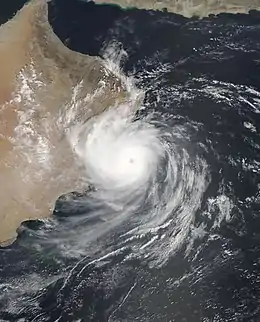  | |
| Duration | September 22 – September 25 |
|---|---|
| Peak intensity | 140 km/h (85 mph) (3-min) 978 hPa (mbar) |
A depression formed in the Arabian Sea and soon intensified into a cyclonic storm and was named Hikaa. The system gradually intensified into a severe cyclonic storm and then reached its peak intensity as a very severe cyclonic storm with 85 mph 3-min sustained wind speeds. Hikaa weakened due to dry air intrusions and made landfall on Oman as a severe tropical cyclone. Hikaa quickly weakened after moving inland and later dissipated.
One person went missing after his boat sank off Duqm.[32] Off the Omani coast, a boat carried 11 Indian fishermen sank due to Hikaa. As of October 17, six of them were confirmed dead, and the other five remained missing.[33]
Land Depression 01
| Depression (IMD) | |
  | |
| Duration | September 29 – October 1 |
|---|---|
| Peak intensity | 45 km/h (30 mph) (3-min) 1002 hPa (mbar) |
A depression formed over Gulf of Kutch and neighborhood Gujarat coast close to Kandla on September 30.[34][35] It weakened into a well-marked low pressure system with an eye visible on satellite at 00:00 UTC on October 1.[36]
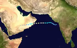
Super Cyclonic Storm Kyarr
| Super cyclonic storm (IMD) | |
| Category 4 tropical cyclone (SSHWS) | |
  | |
| Duration | October 24 – November 1 |
|---|---|
| Peak intensity | 240 km/h (150 mph) (3-min) 922 hPa (mbar) |
A depression formed in the Arabian Sea on October 24, with IMD giving it the identifier ARB 03, later intensifying into a deep depression before JTWC recognized it as Tropical Cyclone 04A. It further intensified and became a cyclonic storm, receiving the name Kyarr from IMD as the fifth cyclonic storm of the season. On October 25, owing to high sea surface temperatures, low shear and a moist environment, Kyarr began a period of rapid intensification and strengthened into a very severe cyclonic storm. Three hours later, Kyarr became an extremely severe cyclonic storm. Early on October 27, Kyarr intensified into a super cyclonic storm, becoming the first one in the basin since Gonu in 2007. The system continued to intensify, attaining maximum three-minute sustained winds of 240 km/h (150 mph) and a minimum barometric pressure of 922 hPa (27.23 inHg), Kyarr began slowly weakening on October 29 as it headed southwest towards the direction of Somalia. Kyarr dissipated off the coast of Somalia on November 1.
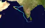
Extremely Severe Cyclonic Storm Maha
| Extremely severe cyclonic storm (IMD) | |
| Category 3 tropical cyclone (SSHWS) | |
  | |
| Duration | October 30 – November 7 |
|---|---|
| Peak intensity | 185 km/h (115 mph) (3-min) 956 hPa (mbar) |
A well-marked low pressure area strengthened into a depression on October 30.[37] The depression continued strengthening as it entered a more favorable environment and was upgraded into a Cyclonic Storm on November 1. Maha continued to intensify, fluctuating in intensity for the next 2 days as it moved along the Indian coast, producing rough surf and moderate coastal flooding along the way before becoming a Very Severe Cyclonic Storm on November 3 and then into an Extremely Severe Cyclonic Storm the next day as it moved parallel to the Indian coast. Maha then began to stall in the Arabian Sea as it reached peak intensity due to a lack of steering currents. Upwelling began to take its toll on the storm, and it weakened back to a Cyclonic Storm as it approached Gujarat. It then made landfall near Gujarat as a tropical depression and quickly weakened afterwards.
In preparation of Maha's impacts, orange alert was issued in four districts of Kerala.[38]
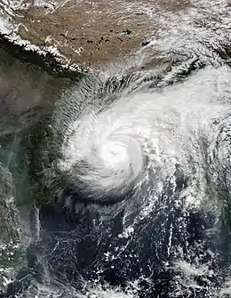
Very Severe Cyclonic Storm Bulbul
| Very severe cyclonic storm (IMD) | |
| Category 3 tropical cyclone (SSHWS) | |
  | |
| Duration | November 6 – November 11 |
|---|---|
| Peak intensity | 140 km/h (85 mph) (3-min) 976 hPa (mbar) |
On November 6, the remnants of Severe Tropical Storm Matmo traversed into the Bay of Bengal and developed into Cyclonic Storm Bulbul. The system quickly intensified into a Severe Cyclonic Storm over the next day. As it continued north, it then strengthened into a Very Severe Cyclonic Storm as the IMD issued coastal warnings for West Bengal.
Bulbul then underwent rapid intensification, becoming a very severe cyclonic storm on November 8.[39]
It was the second Severe Cyclonic Storm to make landfall in West Bengal after Cyclone Aila. The storm produced heavy rain over many parts of West Bengal with Digha receiving 98 mm, Kolkata receiving 101 mm, Halisahar recording 95 mm and Dumdum receiving 90 mm of rain. Strong winds were also reported in many parts of South Bengal. Strong winds of 75 km/h also battered the Kolkata by uprooting many trees. One youth was killed due to uprooting of trees before the storm made landfall.
Cyclonic Storm Pawan
| Cyclonic storm (IMD) | |
| Tropical storm (SSHWS) | |
  | |
| Duration | December 2 – December 7 |
|---|---|
| Peak intensity | 75 km/h (45 mph) (3-min) 998 hPa (mbar) |
On December 2, a depression formed over the southwestern Arabian Sea, east of Somalia. It strengthened into a cyclonic storm on December 4 owing to favorable conditions in the surrounding area, earning the name Pawan.[40] The system continued north, gaining a little more strength, and then turned west the following day,[41] Pawan struggled to maintain its structure due to a high amount of wind shear, but continued to move west towards Somalia. This wind shear caused Pawan's convection to briefly dissipate, but it soon regenerated. Pawan eventually made landfall in the Puntland region of Somalia, just south of Eyl, late on December 6, bringing heavy rain and mudslides to the surrounding areas. It then degenerated into a well-marked low-pressure area inland on December 7.[42]
Pawan killed six people in Somalia.[43] Rainfall accumulations brought by Pawan reached up to 3 inches in Somalia, an unusually large amount of rain for December, resulting in flash flooding in the region. Two vehicles were swept away by torrential rain generated by the storm in Bosaso, while two boats capsized off the coast of Eyl due to rough surf.[42][44] Pawan was the first tropical cyclone to make landfall in Somalia since Cyclone Sagar in 2018.
Deep Depression ARB 06
| Deep depression (IMD) | |
| Tropical storm (SSHWS) | |
  | |
| Duration | December 3 – December 5 |
|---|---|
| Peak intensity | 55 km/h (35 mph) (3-min) 1000 hPa (mbar) |
On December 3, a depression formed over the east-central Arabian Sea, with the IMD marking it as Depression ARB 06. It gradually strengthened into a deep depression soon after. Initial forecasts expected the system to intensify into a cyclonic storm, however, a high amount of wind shear caused it to weaken substantially, and it weakened into a low-pressure area on December 5, west of the Indian coast.
Heavy rains associated with the depression caused extensive flooding in Tamil Nadu.[45] Twenty-four-hour accumulations exceeded 150 mm (5.9 in) in many areas, including 190 mm (7.5 in) in Sathankulam.[46] Officials issued extreme rainfall warnings for six districts and more than 21,500 trained volunteers were placed on standby. The Paravanar River topped its banks, flooding an estimated 10,000 homes.[47] A total of 1,305 huts and 465 homes were destroyed across Tamil Nadu.[48] During then night of December 2, three homes collapsed in Mettupalayam killing 17 occupants. Eight other people died in rain-related incidents.[49]
Deep Depression ARB 08
| Deep depression (IMD) | |
  | |
| Duration | December 8 – December 10 |
|---|---|
| Peak intensity | 55 km/h (35 mph) (3-min) 1000 hPa (mbar) |
On December 6, the JTWC began to monitor an area of low pressure near the newly-formed Cyclonic Storm Pawan. Two days later, on December 8, the low gained more convection and a defined circulation while moving westward, with the IMD classifying the system as Depression ARB 08. The system later intensified into a deep depression during the early hours of December 9. On December 10, the system degenerated into a well-marked low off the coast of Somalia.
Storm names
Within this basin, a tropical cyclone is assigned a name when it is judged to have reached Cyclonic Storm intensity with winds of 65 km/h (40 mph). The names were selected by members of the ESCAP/WMO Panel on Tropical Cyclones between 2000 and May 2004, before the Regional Specialized Meteorological Center in New Delhi started to assign names in September 2004. There is no retirement of tropical cyclone names in this basin as the list of names is only scheduled to be used once before a new list of names is drawn up. Should a named tropical cyclone move into the basin from the Western Pacific, it will retain its original name. The next eight available names from the List of North Indian Ocean storm names are below.
|
|
Pabuk entered the basin from the Gulf of Thailand as a cyclonic storm; its name was assigned by the Japan Meteorological Agency.
Season effects
This is a table of all storms in the 2019 North Indian Ocean cyclone season. It mentions all of the season's storms and their names, duration, peak intensities (according to the IMD storm scale), damage, and death totals. Damage and death totals include the damage and deaths caused when that storm was a precursor wave or extratropical low, and all of the damage figures are in 2019 USD.
| Name | Dates active | Peak classification | Sustained wind speeds |
Pressure | Areas affected | Damage (USD) |
Deaths | Refs |
|---|---|---|---|---|---|---|---|---|
| Pabuk | January 4 – 7 | Cyclonic storm | 85 km/h (50 mph) | 998 hPa (29.47 inHg) | Thailand, Myanmar, Andaman Islands | None | None | |
| Fani | April 26 – May 4 | Extremely severe cyclonic storm | 215 km/h (130 mph) | 932 hPa (27.52 inHg) | Sumatra, Nicobar Islands, Sri Lanka, East India, Bangladesh, Bhutan | $8.1 billion | 89 | [50][51] [52][53] [54] |
| Vayu | June 10 – 17 | Very severe cyclonic storm | 150 km/h (90 mph) | 970 hPa (28.64 inHg) | Northern Maldives, India, Southern Pakistan, East Oman | $140 thousand | 8 | [55][56] [57] |
| BOB 03 | August 6 – 11 | Deep depression | 55 km/h (35 mph) | 988 hPa (29.18 inHg) | East India, Bangladesh | Unknown | 3 | [31] |
| Hikaa | September 22 – 25 | Very severe cyclonic storm | 140 km/h (85 mph) | 972 hPa (28.70 inHg) | Western India, Oman, Saudi Arabia, Yemen | Unknown | 5 | [33] |
| LAND 01 | September 30 – October 1 | Depression | 45 km/h (30 mph) | 1004 hPa (29.65 inHg) | Western India | None | None | |
| Kyarr | October 24 – November 1 | Super cyclonic storm | 240 km/h (150 mph) | 922 hPa (27.02 inHg) | Western India, Oman, Yemen, Somalia | Minor | None | |
| Maha | October 30 – November 7 | Extremely severe cyclonic storm | 185 km/h (115 mph) | 956 hPa (28.23 inHg) | Sri Lanka, Southern India, Maldives, Western India, Oman | Minor | None | |
| Bulbul | November 6 – 11 | Very severe cyclonic storm | 140 km/h (85 mph) | 976 hPa (28.82 inHg) | Myanmar, Andaman and Nicobar Islands, Eastern India, Bangladesh | $3.37 billion | 41 | [58][59][60][61] |
| Pawan | December 2 – 7 | Cyclonic storm | 75 km/h (45 mph) | 998 hPa (29.47 inHg) | Somalia | Unknown | 6 | [43] |
| ARB 06 | December 3 – 5 | Deep depression | 55 km/h (35 mph) | 1002 hPa (29.53 inHg) | Tamil Nadu | Unknown | 25 | [49] |
| ARB 08 | December 8 – 10 | Deep depression | 55 km/h (35 mph) | 1004 hPa (29.53 inHg) | Socotra, Somalia | None | None | |
| Season aggregates | ||||||||
| 12 systems | January 4 – December 10 | 240 km/h (150 mph) | 922 hPa (27.02 inHg) | ≥$11.5 billion | 177 | |||
See also
- Tropical cyclones in 2019
- 2019 Atlantic hurricane season
- 2019 Pacific hurricane season
- 2019 Pacific typhoon season
- South-West Indian Ocean cyclone seasons: 2018–19, 2019–20
- Australian region cyclone seasons: 2018–19, 2019–20
- South Pacific cyclone seasons: 2018–19, 2019–20
Notes
References
- "Annual Frequency of Cyclonic Disturbances (Maximum Wind Speed of 17 Knots or More), Cyclones (34 Knots or More) and Severe Cyclones (48 Knots or More) Over the Bay of Bengal (BOB), Arabian Sea (AS) and Land Surface of India" (PDF). India Meteorological Department. Retrieved 30 October 2015.
- RSMC — Tropical Cyclones New Delhi (2010). Report on Cyclonic Disturbances over North Indian Ocean during 2009 (PDF) (Report). India Meteorological Department. pp. 2–3. Archived from the original (PDF) on 2010-12-04. Retrieved May 24, 2011.
- https://blogs.scientificamerican.com/eye-of-the-storm/tropical-cyclone-kyarr-150-mph-winds-arabian-seas-2nd-strongest-storm-on-record/
- "IMD – Press Release". Archived from the original on 2019-11-04.
- "Tropical Cyclone Advisory Bulletin No. 1" (PDF). India Meteorological Department. 4 January 2019. Archived (PDF) from the original on 6 January 2019. Retrieved 6 January 2019.
- TC Advisory 1. India Meteorological Department (Report). 27 April 2019. Archived from the original on 30 April 2019. Retrieved 30 April 2019.
- TC Advisory 4. India Meteorological Department (Report). 28 April 2019. Archived from the original on 30 April 2019. Retrieved 30 April 2019.
- TC Advisory 11. India Meteorological Department (Report). 29 April 2019. Archived from the original on 30 April 2019. Retrieved 30 April 2019.
- Tropical Cyclone 01B (Fani) Warning 012. Joint Typhoon Warning Center (Report). Naval Meteorology and Oceanography Command. 29 April 2019. Archived from the original on 30 April 2019. Retrieved 30 April 2019.
- TC Advisory 15. India Meteorological Department (Report). 30 April 2019. Archived from the original on 30 April 2019. Retrieved 30 April 2019.
- Extremely Severe Cyclonic Storm “FANI” over eastcentral equatorial Indian Ocean and adjoining southeast Bay of Bengal (26 April – 04 May, 2019): Summary (PDF) (Report). India Meteorological Department. Retrieved 28 September 2019.
- Joint Typhoon Warning Center: 2019 North Indian Ocean Best Track (Report). Joint Typhoon Warning Center. Retrieved 7 January 2021.
- "Cyclone Fani makes landfall in India". Deutsche Welle. 3 May 2019. Retrieved 3 May 2019.
- "Cyclone Fani to Make Landfall Near Puri Today, Odisha Moves 11 Lakh People to Safety". CNN-News18. 3 May 2019. Retrieved 3 May 2019.
- TC Advisory 28. India Meteorological Department (Report). 3 May 2019. Archived from the original on 4 May 2019. Retrieved 4 May 2019.
- TC Advisory 30. India Meteorological Department (Report). Archived from the original on 4 May 2019. Retrieved 4 May 2019.
- Bulletin 65 (PDF). India Meteorological Department (Report). 4 May 2019. Archived from the original (PDF) on 4 May 2019. Retrieved 4 May 2019.
- "Weekly Tropical Climate Note".
- Gopal, Neetha (13 June 2019). "Tropical Cyclone Advisory Bulletin #18" (PDF). India Meteorological Department. Archived from the original (PDF) on 13 June 2019. Retrieved 13 June 2019.
- "Tropical Cyclone Warning #12 (06Z)". Joint Typhoon Warning Center. Naval Meteorology and Oceanography Command. 13 June 2019. Archived from the original on 13 June 2019. Retrieved 13 June 2019.
- Very Severe Cyclonic Storm “VAYU” over southeast & adjoining eastcentral Arabian Sea and Lakshadweep (10 June – 17 June, 2019): Summary (PDF) (Report). India Meteorological Department. Retrieved 28 September 2019.
- Devi, Sunitha (14 June 2019). "Tropical Cyclone Advisory Bulletin #25 (03Z)" (PDF). India Meteorological Department. Archived from the original (PDF) on 14 June 2019. Retrieved 14 June 2019.
- "Tropical Cyclone Warning #16". Joint Typhoon Warning Center. Naval Meteorology and Oceanography Command. 14 June 2019. Archived from the original on 14 June 2019. Retrieved 14 June 2019.
- Kumar, Naresh (16 June 2019). "National Bulletin #53" (PDF). India Meteorological Department. Archived from the original (PDF) on 17 June 2019. Retrieved 17 June 2019.
- Kumar, Naresh (16 June 2019). "Tropical Cyclone Advisory Bulletin #47" (PDF). India Meteorological Department. Archived from the original (PDF) on 17 June 2019. Retrieved 17 June 2019.
- Devi, Sunitha (17 June 2019). "National Bulletin #56" (PDF). India Meteorological Department. Archived from the original (PDF) on 17 June 2019. Retrieved 17 June 2019.
- "Tropical Cyclone Warning #27". Joint Typhoon Warning Center. Naval Meteorology and Oceanography Command. 17 June 2019. Archived from the original on 17 June 2019. Retrieved 17 June 2019.
- Devi, Sunitha (17 June 2019). "National Bulletin #58" (PDF). India Meteorological Department. Archived from the original (PDF) on 17 June 2019. Retrieved 17 June 2019.
- Pattanaik, D. R. (17 June 2019). "National Bulletin #61 (18Z)" (PDF). India Meteorological Department. Archived from the original (PDF) on 18 June 2019. Retrieved 18 June 2019.
- "Heavy rain batters Odisha; a flood-like situation in some areas". India Today. Press Trust of India. August 7, 2019. Retrieved August 9, 2019.
- "3 killed, 2 missing in Odisha due to floods". Odisha Sun Times. August 8, 2019. Retrieved August 9, 2019.
- "Person missing at sea after boat sinks in Oman". Times of Oman. September 25, 2019. Retrieved September 26, 2019.
- "TN: Fisherman killed in cyclone off Oman laid to rest in home town". Times of India. October 17, 2019. Retrieved October 18, 2019.
- "Tropical Weather Outlook". India Meteorological Department. September 30, 2019. Archived from the original on October 4, 2019. Retrieved October 4, 2019.
- "IWB (Evening) Dated 30-09-2019". India Meteorological Department. September 30, 2019. Archived from the original on October 4, 2019. Retrieved October 4, 2019.
- "IWB (EVENING) DATED 01-10-2019". India Meteorological Department. September 30, 2019. Archived from the original on October 4, 2019. Retrieved October 4, 2019.
- "RSMC Bulletin" (PDF). 30 October 2019. Retrieved 30 October 2019.
- http://www.uniindia.com/cyclone-maha-orange-alert-in-four-districts-of-kerala/south/news/1774974.html
- "Tropical Cyclone Matmo is reborn as Bulbul". Al Jazeera News.
- "One Deep Depression over Arabian Sea Gains Strength to Form Cyclone Pawan, Other Weakens into Depression". The Weather Channel India. December 4, 2019. Retrieved December 7, 2019.
- Gutro, Rob (December 5, 2019). "NASA tracking Tropical Storm 06A through Arabian Sea". EurekAlert. Retrieved December 7, 2019.
- Leister, Eric; Kelly, Maura (December 7, 2019). "Somalia to stay on high alert for another tropical threat in wake of Pawan". Accuweather. Retrieved December 7, 2019.
- Somalia: Tropical Storm Pawan Leaves Thousands in Need. Action Against Hunger. December 13, 2019. ReliefWeb. Retrieved March 13, 2020.
- @MoradNews (December 6, 2019). "Cyclone #Pawan makes landfall in parts of #Puntland region, Northern #Somalia. Heavy rains & winds killed people, destroyed livestock. 2 vehicles swept away by torrential downpours near #Bosaso and 2 boats capsized off the coast of Eyl town. Phone lines cut in parts of the region" (Tweet) – via Twitter.
- Heavy rains disrupt normal life in Tamil Nadu and Puducherry (Report). ReliefWeb. Government of India. December 2, 2019. Retrieved December 9, 2019.
- TWC India Edit Team (December 2, 2019). "25 Killed as Heavy Rains Throw Life Out of Gear in Chennai, Tamil Nadu; More Rains Forecast". The Weather Channel. Retrieved December 9, 2019.
- "Parts of Tamil Nadu flooded, more rain likely". The New Indian Express. December 2, 2019. Retrieved December 9, 2019.
- "TN rains: Death toll rises to 25, CM reviews monsoon preparedness". Yahoo! News. The News Minute. December 2, 2019. Retrieved December 9, 2019.
- Dravida Thambi (December 3, 2019). "Flood alert issued in Tamil Nadu, 3 houses collapse, 17 dead". The Free Press Journal. Retrieved December 9, 2019.
- Ahmad, Adil. "India: Death toll from cyclone Fani climbs to 64". AA.com. Retrieved 12 May 2019.
- "Lightning kills 8 in Uttar Pradesh". New Indian Express. 3 May 2019. Retrieved 5 May 2019.
- "Cyclone Fani leaves trail of destruction in Bangladesh; 17 dead, several hurt". Northeast Now. 5 May 2019. Retrieved 5 May 2019.
- "Odisha estimates loss at ₹12,000 Cr due to cyclone Fani". The Hindu Business Line. 15 May 2019. Retrieved 16 May 2019.
- "Global Catastrophe Recap: First Half of 2019" (PDF). Aon Benfield. Retrieved 12 August 2019.
- "Rains and strong winds hit Mumbai; 1 killed, 2 injured as portion of cladding collapses at Churchgate Railway Station". Mumbai Mirror. 12 June 2019. Archived from the original on 14 June 2019. Retrieved 14 June 2019.
- Saiyed, Kamal; Mohanty, Aishwarya (13 June 2019). "Gujarat: Six killed, 2 injured in 3 districts ahead of Vayu landfall". The Indian Express. Archived from the original on 14 June 2019. Retrieved 14 June 2019.
- Waqar Bhatti, M. (15 June 2019). "Elderly man apparently dies due to heat stroke as weathermen predicts another very hot, humid day on Sunday". The News International. Archived from the original on 16 June 2019. Retrieved 16 June 2019.
- 'Bulbul' claims 2 lives in Odisha, extensive damage to crops (Report). ReliefWeb. Government of India. November 10, 2019. Retrieved December 9, 2019.
- "Cyclone Bulbul caused Rs 23,811 crore losses: West Bengal Government". India Today. Press Trust of India. November 17, 2019. Retrieved December 9, 2019.
- "Cyclone 'Bulbul' destroys 9,455 homesteads in Khulna". The Independent. November 11, 2019. Retrieved December 9, 2019.
- "Cyclone Bulbul causes Tk 263cr loss in 16 dists". The Independent. November 13, 2019. Retrieved December 9, 2019.
External links
| Wikimedia Commons has media related to 2019 North Indian Ocean cyclone season. |