2016 Chiloé earthquake
The 2016 Chiloé earthquake with a magnitude of Mww 7.6 struck that 225 kilometres (140 mi) south-west of Puerto Montt in southern Chile at 11:22 local time, 25 December.[1][2] The earthquake triggered a tsunami warning on coasts located up to 1,000 kilometres (620 mi) from the quake's epicentre, generating massive evacuation across the Greater Chiloé Island, after advice from the Chilean government.[2] Although there was damage in some parts of the island, the government reported no casualties.
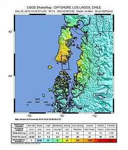 ShakeMap of the earthquake | |
| UTC time | 2016-12-25 14:22:27 |
|---|---|
| ISC event | 609939179 |
| USGS-ANSS | ComCat |
| Local date | December 25, 2016 |
| Local time | 11:22 UTC-3 |
| Magnitude | 7.6 Mw[1] |
| Depth | 34.6 km (USGS)[1] |
| Epicenter | 43.416°S 73.880°W[1] |
| Type | Thrust fault |
| Max. intensity | VIII (Severe) |
| Aftershocks | > 30 |
| Casualties | 0 |
Earthquake
The earthquake occurred as a result of shallow thrust faulting in southern Chile. At the location of the earthquake, the oceanic Nazca plate converges with and subducts beneath the South America plate in an east-northeast direction, at a rate of approximately 73 mm/yr. The location, depth and shallow thrusting focal mechanism solution[3] all indicate this earthquake likely occurred on the subduction zone interface.[1]
References
- "M7.6 – 39km SSW of Puerto Quellón, Chile". United States Geological Survey. Retrieved December 25, 2016.
- "Chile earthquake triggers tsunami warning". BBC. 25 December 2016. Retrieved 25 December 2016.
- "M 7.6 - 41km SW of Puerto Quellon, Chile --- Focal mechanism solution". USGS Earthquake.
External links
- The International Seismological Centre has a bibliography and/or authoritative data for this event.