2016 Solomon Island earthquake
On 9 December 2016 at 4:38 a.m. (UTC +11) local time (17:38:46 UTC), the Solomon Islands region was rocked by an Mww 7.8 earthquake, centered 30 km off San Cristobal Island, about 61 km southwest of Kirakira, the capital of Makira-Ulawa Province.[1] Initially registering magnitude 8.0, later downgraded to 7.8, the temblor prompted tsunami warnings that kept countries surrounding the Coral, Tasman and Solomon Sea on high alert, but was later cancelled. A large aftershock of magnitude 6.9 occurred shortly afterwards. This earthquake was largely felt, waking many residents who later ran to high ground for fears of a potential tsunami.[2] The earthquake killed a child and affected some 34,000 people in Makira, South Malaita and Guadalcanal Island where many had lost their homes or had no access to basic needs.[3] Earthquakes are common in this region, with little or no fatalities. This earthquake is tied with three other magnitude 7.8 earthquakes for the second largest earthquake of 2016.[4] On December 17, the Solomon Islands would be rattled again by a 7.9 magnitude earthquake, this time 54 km east of Taron, Papua New Guinea.
 | |
  | |
| UTC time | 2016-12-08 17:38:46 |
|---|---|
| ISC event | 611831246 |
| USGS-ANSS | ComCat |
| Local date | 8 December 2016 |
| Duration | >1 minute |
| Magnitude | 7.8 Mww |
| Depth | 40.0 km |
| Epicenter | 10°40′52″S 161°19′37″E |
| Fault | San Cristobal-New Britain Trench |
| Type | Oblique-reverse |
| Total damage | 1000+ buildings damaged or destroyed |
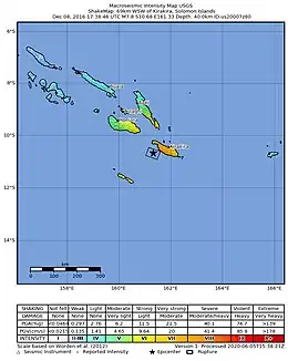
| Max. intensity | IX (Violent) |
| Tsunami | 0.43 meters |
| Landslides | Yes |
| Aftershocks | Mww 6.5 Mww 6.9 |
| Casualties | 1 dead |
Geological setting
The Australian Woodlark, Solomon Sea and Pacific Plates are converging at a rate of 97 mm/yr.[5] The earthquake was a result of interaction between the Australian and Pacific Plates along a subduction zone. Subduction of the Australian Plate has also given rise to volcanoes in the region. This region of the world lies along the Pacific Ring of Fire, where 90 percent of all earthquake and volcanic activity is concentrated here.[6]
Earthquake
The earthquake occurred along the boundary interface where the Australian and Pacific Plates make contact. Focal mechanism suggest that this earthquake was a result of oblique-reverse faulting.[7] The earthquake did not rupture to the trench, terminating at a depth of 20 km, with its epicenter at 40 km. An average slip has been estimated at 5 meters.[8]
Tsunami
The main earthquake triggered tsunami warnings directed at the Solomon Islands, Vanuatu, Papua New Guinea, Nauru, New Caledonia, Tuvalu and Kosrae in the Federated States of Micronesia, issued by the Pacific Tsunami Warning Center.[2] In New Caledonia, people were ordered to evacuate and leave for higher ground. Warnings for American Samoa and Hawaii were cancelled shortly after.[9] The International Tsunami Information Center warned of tsunamis between 1 to 3 meters. However, the highest waves were measured at only 0.43 meters (1.41 feet) on Marika Island.[10]
Aftermath
Phone and electricity lines were cut-off throughout the country in the immediate aftermath.[14] On Malaita Island, there were reports that 35 to 40 buildings had been damaged.[15] In Guadalcanal, the collapse of a home killed one person.[16] In Kirakira, many homes, a hospital, a church, and the World Vision office sustained serious damage.[17] Damage at the hospital forced the evacuation of 20 people.[18] Two schools in Marika and Ugi were completely destroyed. Fissures and landslides were also seen in the affected region.[19] People who fled to higher ground continued to stay on the hills for fears of a large tsunami. Twenty-five houses were washed away from the moderate tsunami.[20] In total, over 1000 homes were damaged, along with 20 schools and four clinics.[21] More than 7,000 people were affected by the earthquake.
International reaction
Julie Bishop, the Australian foreign minister at the time said that the country is prepared to offer their support to the Solomon Islands.[22]
See also
References
- Thomson Reuters (9 December 2016). "Solomon Islands Earthquake Triggers Tsunami Alert In South Pacific". NDTV. Retrieved 1 December 2020.
- "Magnitude 7.8 quake hits off Solomons". RNZ. 9 December 2016. Retrieved 1 December 2020.
- Reid, Kathryn (21 August 2018). "Solomon Islands: Earthquakes, tsunamis, volcanoes, and floods". World Vision. Retrieved 1 December 2020.
- Breslin, Sean (8 December 2016). "7.8 Earthquake Strikes Solomon Islands; Tsunami Watch Canceled for Hawaii". The Weather Channel. Retrieved 1 December 2020.
- Kaustubh Thirumalai, Frederick W. Taylor, Chuan-Chou Shen, Luc L. Lavier, Cliff Frohlich, Laura M. Wallace, Chung-Che Wu, Hailong Sun & Alison K. Papabatu (30 June 2015). "Variable Holocene deformation above a shallow subduction zone extremely close to the trench". Nature Communications. 6: 7607. Bibcode:2015NatCo...6.7607T. doi:10.1038/ncomms8607. S2CID 8275538.CS1 maint: multiple names: authors list (link)
- Hanna, O'Sullivan, Jason, Donnie (8 December 2016). "Solomon Islands tsunami threat over after 7.8 quake". CNN. Retrieved 1 December 2020.
- "M 7.8 – 69km WSW of Kirakira, Solomon Islands". US Geological Survey. Retrieved 1 December 2020.
- "Solomon Islands Tsunami on Dec. 8, 2016". Retrieved 1 December 2020.
- "Large earthquake strikes off Solomon Islands". DW. 8 December 2016. Retrieved 1 December 2020.
- "Tsunami Event Information SOLOMON ISLANDS". NOAA NCEI. Retrieved 1 December 2020.
- "M 6.5 – 79km WSW of Kirakira, Solomon Islands". US Geological Survey. Retrieved 1 December 2020.
- "M 6.9 – 92km WSW of Kirakira, Solomon Islands". US Geological Survey. Retrieved 1 December 2020.
- "Solomon Islands recover from 7.8-magnitude quake amid continuing aftershocks". National Thailand. 10 December 2016. Retrieved 1 December 2020.
- "Solomon Islands tsunami warning lifted after powerful 7.8 quake". BBC. 8 December 2016. Retrieved 1 December 2020.
- "Damage assessment after M7.8 earthquake in Solomon Islands". The Watchers. 9 December 2016. Retrieved 1 December 2020.
- "Solomon Islands: Earthquake – Dec 2016". Retrieved 1 December 2020.
- "Significant Earthquake Information". NOAA NCEI. Retrieved 1 December 2020.
- Perry, Nick (9 December 2016). "World Vision says hundreds affected by Solomon Islands quake". PhysOrg. Retrieved 2 December 2020.
- Westbrook, Greenfield, Tom, Charlotte (9 December 2020). "Residents take to the hills as powerful quake hits Solomon Islands". Reuters. Retrieved 1 December 2020.
- WESTBROOK, GREENFIELD, TOM, CHARLOTTE (9 December 2020). "Residents Take to the Hills as Powerful Quake Hits Solomon Islands". JakartaGlobe. Retrieved 2 December 2020.
- "Six months on after Solomon Islands' 7.8 magnitude earthquake". World Vision. 1 June 2017. Retrieved 1 December 2020.
- Hardy, Catherine (9 December 2016). "Australia "ready to help" quake-hit Solomons". euronews. Retrieved 1 December 2020.