Aïn Arnat
Aïn Arnat (in Arabic : عين أرنات) is a town and commune in Sétif Province in north-eastern Algeria. [4]
Ain Arnat
عين أرنات ⴰⵉⵏ ⴰⵔⵏⴰⵜ | |
|---|---|
.jpg.webp) a village in Ain arnat | |
| Nickname(s): Ain arnat | |
| Motto(s): By the people and for the people | |
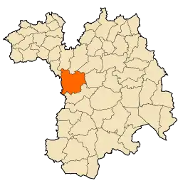 | |
 Ain Arnat Location within Algeria | |
| Coordinates: 36°11′00″N 5°19′00″E | |
| Country | |
| Province | Sétif Province |
| Government | |
| • Mayor | Lakhder Elkolli |
| Area | |
| • Land | 7,820 sq mi (20,255 km2) |
| Population (2008) | |
| • Total | 43 551[1] |
| Time zone | [[UTC+1[2]]] (CET[3]) |
Geography
Aïn Arnat is located 7 km east of the city of Sétif and 293 km from the capital Algiers. The Aïn Arnat District has four communes which are Aïn Arnat, Aïn Abessa, El Ouricia and Mezloug. Bordered by Ain Abessa commune from the north, Mezloug from the south, Sétif from the east and by Bordj Bou Arréridj Province from the west.[5]
Demography
The total population of Aïn Arnat was evaluated at 43 551 inhabitants in 2008 with a density of 215 inhabitants/km2.[6]
Education
Aïn Arnat district has two high schools and four middle schools, And more than 12 Primary schools People who graduate mostly go afterwards to University Ferhat Abbas or University Mohamed Lamine Debaghine in Setif.[7]
Climate
Ain arnat has a Dry Mediterranean climate (Köppen climate classification Csa),[8] its summer is hot and dry, whilst its winter is cool and moist.
due to its location on the High Plateaus at an elevation of 1,096 metres (3,596 ft), it is one of the coldest regions during winter in Algeria.It frequently sees an annual snowfall of up to 40 centimetres (16 in). Flash floods are rare but have recently occurred around the spring and fall seasons. The summer is fairly hot where extreme heat waves are common around the month of July where temperatures can sometimes even reach 40 °C (104 °F).[9]
| Climate data for Ain arnat | |||||||||||||
|---|---|---|---|---|---|---|---|---|---|---|---|---|---|
| Month | Jan | Feb | Mar | Apr | May | Jun | Jul | Aug | Sep | Oct | Nov | Dec | Year |
| Record high °C (°F) | 21.5 (70.7) |
21.6 (70.9) |
28.0 (82.4) |
29.1 (84.4) |
38.4 (101.1) |
39.3 (102.7) |
40.4 (104.7) |
40.2 (104.4) |
39.0 (102.2) |
33.0 (91.4) |
26.4 (79.5) |
21.8 (71.2) |
40.4 (104.7) |
| Average high °C (°F) | 10.0 (50.0) |
11.7 (53.1) |
15.0 (59.0) |
17.4 (63.3) |
23.5 (74.3) |
29.4 (84.9) |
33.4 (92.1) |
32.9 (91.2) |
27.2 (81.0) |
21.7 (71.1) |
14.7 (58.5) |
10.7 (51.3) |
20.6 (69.2) |
| Average low °C (°F) | 1.3 (34.3) |
1.9 (35.4) |
4.1 (39.4) |
5.8 (42.4) |
10.7 (51.3) |
15.3 (59.5) |
18.7 (65.7) |
18.9 (66.0) |
14.8 (58.6) |
10.8 (51.4) |
5.3 (41.5) |
2.3 (36.1) |
9.2 (48.5) |
| Record low °C (°F) | −10.5 (13.1) |
−8.3 (17.1) |
−5.5 (22.1) |
−4.5 (23.9) |
−1.3 (29.7) |
1.1 (34.0) |
8.0 (46.4) |
8.0 (46.4) |
4.5 (40.1) |
0.6 (33.1) |
−5.5 (22.1) |
−8.7 (16.3) |
−10.5 (13.1) |
| Average precipitation mm (inches) | 36.7 (1.44) |
25.6 (1.01) |
34.6 (1.36) |
42.4 (1.67) |
43.2 (1.70) |
23.5 (0.93) |
17.7 (0.70) |
13.4 (0.53) |
42.8 (1.69) |
30.5 (1.20) |
36.4 (1.43) |
45.0 (1.77) |
391.8 (15.43) |
| Average snowy days (≥ 1 cm) | 3 | 3 | 2 | 1 | 0 | 0 | 0 | 0 | 0 | 0 | 0 | 2 | 11 |
| Source: Meoweather [10] | |||||||||||||
Transportation
Aïn Arnat has the main and only Airport in Sétif which is Ain Arnat Airport or Sétif International Airport Adding to that The National road N°5 which passes by it, and that makes it one of the most important communes in the wilaya of Sétif.[11]
Notes and references
- 'Ain arnat area
- 'Ain arnat timezone
- 'Ain arnat Timezone
- "Communes of Algeria". Statoids. Archived from the original on 29 November 2010. Retrieved December 12, 2010. Commune of ain arnat, Setif: Statoids, 2017 [2006]
- Monography Archived 2017-02-02 at the Wayback Machine in the governmental website www.bibans-info.gov.dz, Retrieved February 17th 2017. Setif Geography, Ain arnat: Biban Website, 2013
- Monography Archived 2017-02-02 at the Wayback Machine in the government website w www.bibans-info.gov.dz, Retrieved February 17th 2017. Monography Ain arnat, Ain arnat: Biban website, 2013
- 'Education Ain arnat Education, Setif: setif info, 2013 [2013]
- 'Ain arnat climate
- "Ain arnat Climate". Meoweather. Retrieved 2013-03-06.
- "Sétif average weather by month". Meoweather. Retrieved 2013-03-06.
- "Transportation Setif transportation, Ain arnat: Setif info, 2017 [2013]
.svg.png.webp)