A339 road
The A339 is a 32-mile-long (51 km) A road in England. It is the main road between Newbury in Berkshire and Alton in Hampshire. It also forms the eastern and northern parts of the Basingstoke Ring Road. Its most northern end eventually merges into the A34 north of Newbury just before meeting the M4 at J13 (Chieveley services).
| |
|---|---|
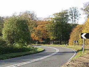 Bend on the A339, near Winslade is typical of the many bends between Basingstoke and Alton | |
| Major junctions | |
| North end | Newbury |
| South end | Alton |
| Location | |
| Counties | Hampshire, Berkshire |
| Road network | |
Points of interest
| Point | Coordinates (Links to map resources) |
OS Grid Ref | Notes |
|---|---|---|---|
| Newbury, Berkshire | 51.4376°N 1.3210°W | Start, A34, Snelsmore Common, Berkshire | |
| Alton, Hampshire | 51.1359°N 0.9775°W | End, A31, Alton, Hampshire |
| Wikimedia Commons has media related to A339 road (England). |
A roads in Zone 3 of the Great Britain road numbering scheme | ||
|---|---|---|
This article is issued from Wikipedia. The text is licensed under Creative Commons - Attribution - Sharealike. Additional terms may apply for the media files.
