A41 autoroute
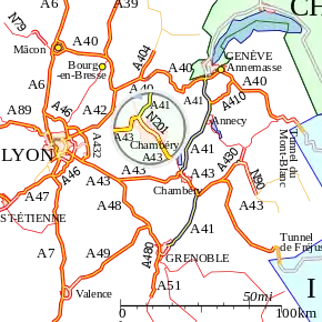
The A41 autoroute, also known as l'autoroute alpine, is a French motorway. The road passes through the French alps connecting the city of Grenoble with the A40 near Geneva. It is made of two sections separated by the N201 and A43 autoroute at Chambéry.
| |
|---|---|
| Autoroute Alpine | |
 | |
| Route information | |
| Length | 112.9 km (70.2 mi) |
| Existed | 1975–present |
| Major junctions | |
| South end | Grenoble |
| North end | A40 (near Genève) |
| Highway system | |
| Autoroutes of France
| |
Characteristics
- 2x2 lanes
- 38.5 km long
- Service areas
History
- 1975 : Opened the section between Annecy and Rumilly
- 1977 : Opened the section between Chambéry and Annecy
- 1978 : Opened the section between Grenoble and Chambéry
- 1981 : Junction with the A40 autoroute.
- 2008 : Opened the 19 km section between Saint-Julien-en-Genevois and Villy-le-Pelloux including Mont-Sion tunnel (3,100 m).
Junctions
Geneva to Chambéry
| Exit/Junction | Destination |
| Exchange A40-A41 Motorway currently starts at Bonneville at a junction with the This will become the | |
| (La Roche-sur-Foron) Towns served: | |
| (Cruseilles) Towns served: | |
| (Annecy nord) Towns served: | |
| (Annecy sud) Towns served: | |
| (Rumilly) Towns served: | |
| (Aix-les-Bains nord) Towns served: | |
| (Aix-les-Bains sud) Towns served: | |
| Exchange A41-A43-N201 Autoroute starts with a junction with the | |
Chambéry to Grenoble
| Exit/Junction | Destination |
| Traffic follows the | |
| Exchange A43-A41 Autoroute starts again with a junction with the | |
| (Pontcharra) Towns served: Pontcharra, La Rochette | |
| (Le Touvet) Towns served: Le Touvet, Allevard | |
| ('Crolles-Brignoud) Towns served: Brignoud, Crolles, Bernin | |
| (St-Ismier-Villard-Bonnot) Towns served: Villard Bonnot, St Ismier | |
| (Montbonnot-Domène) Towns served: Montbonnot, Domène | |
| ('Meylan Est-ZIRST) Towns served: Meylan, | |
| (La Tronche-Meylan) Towns served: Meylan-plaine, La Tronche, Grenoble-Centre, Corenc | |
| The Autoroute terminates as the Avenue de Verdun (the | |
External links
- A41 autoroute in Saratlas
 |
| | |
This article is issued from Wikipedia. The text is licensed under Creative Commons - Attribution - Sharealike. Additional terms may apply for the media files.
