A48 autoroute
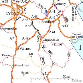
The A48 autoroute, also known as l'autoroute du Dauphiné, is a motorway in France connecting the A43 with the city of Grenoble.
| |
|---|---|
| Autoroute du Dauphiné | |
 | |
| Route information | |
| Part of | |
| Length | 52.5 km (32.6 mi) |
| Existed | 1968–present |
| Major junctions | |
| South end | A43 |
| North end | Grenoble |
| Highway system | |
| Autoroutes of France | |

An extension north to Ambérieu is proposed in the medium term.
Characteristics
- 2x2 lanes
- 2x3 lanes between the A49 and A480 autoroutes (10 km)
- 97 km long
- Service areas
History
- 1968: The first toll free section opened between the Bastille (Grenoble northern edge) and Voreppe as part of the preparations for the Winter Olympics held in the city and surrounding area.
- 1975: Opening of the toll section between Voreppe and the A43 managed by AREA.
Junctions
| Exit/Junction | Destination |
| Exchange A48-A43 | |
| (Le Grand-Lemps) Towns served: Rives | |
| (Champfeuillet) Towns served: Voiron | |
| (Voiron-Moirans) Towns served: Voiron | |
| Exchange A49-A48 | |
| (Veurey) Towns served: Voreppe | |
| (Voreppe) Towns served: Voreppe | |
| (Saint-Egreve) Towns served: Saint-Egreve | |
| (ZI Saint-Egreve-ZI/Saint-Martin-the-Vinoux) Towns served: Grenoble | |
| Exchange A48-A480 | |
| (Europôle-Polygon Scientific Grenoble) Towns served: Grenoble | |
Places of interest
The following list indexes towns and places of interest that can be visited from the motorway:
- River Isère
- Col de Rossatière
- Lac de Paladru
- Chartreuse Mountains
Future
There are proposals to extend the autoroute north from Bourgoin-Jallieu to Ambérieu-in-Bugey and connecting to the A42 autoroute.
External links
- A48 autoroute in Saratlas
 |
| | |
This article is issued from Wikipedia. The text is licensed under Creative Commons - Attribution - Sharealike. Additional terms may apply for the media files.