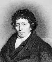
Aaron Arrowsmith
Aaron Arrowsmith (1750–1823) was an English cartographer, engraver and publisher and founding member of the Arrowsmith family of geographers.
Aaron Arrowsmith | |
|---|---|
 | |
| Born | 1750 |
| Died | 1823 (aged 72–73) |
| Nationality | British |
| Occupation | Cartographer Engraver |
Life
He moved to Soho Square, London from Winston, County Durham when about twenty years of age, and was employed by John Cary, the engraver and William Faden. He became Hydrographer to the Prince of Wales c. 1810 and subsequently to the King in 1820. In January 1790 he made himself famous by his large chart of the world on Mercator projection. Four years later he published another large map of the world on the globular projection, with a companion volume of explanation. The maps of North America (1796) and Scotland (1807) are the most celebrated of his many later productions. [1]
In 1804 63 maps drawn by Arrowsmith and Samuel Lewis of Philadelphia (publisher of William Clark's manuscript map of the Northwest)[2] were published in the New and elegant General Atlas Comprising all Discoveries to the Present Time. Later editions of the atlas were published in 1805, 1812, and 1819. The 1804 and 1812 editions are digitized in the David Rumsey map collection.
He left two sons, Aaron and Samuel, the elder of whom was the compiler of the Eton Comparative Atlas, of a Biblical atlas, and of various manuals of geography.[1]
Aaron Arrowsmith the elder was responsible for organising the volume of maps for Rees's Cyclopædia, 1802–19.
The business was thus carried on in company with John Arrowsmith (1790–1873), nephew of the elder Aaron. In 1821, they published a more complete North American map from a combination of a maps obtained from the Hudson's Bay Company and Aaron's previous one.
Mount Arrowsmith, situated east of Port Alberni on Vancouver Island, British Columbia, is named for Aaron Arrowsmith and his nephew John Arrowsmith.
Maps published
- Chart of the world on Mercator's projection, exhibiting all the new discoveries to the present time: with the tracks of the most distinguished navigators since the year 1700, carefully collected from the best charts, maps, voyages, &c extant. , 1790 (8 sheets)
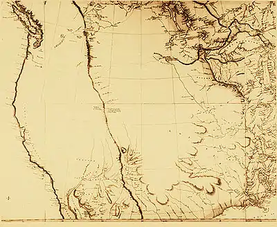
- A Map Exhibiting All the New Discoveries in the Interior Parts of North America, 1 January 1795, with numerous other editions, most notably 1802, 1811, 1814, and 1818. The 1802 version of this map was studied closely by Meriwether Lewis prior to the Lewis and Clark Expedition and the 1811 edition was updated with the published information from that expedition in the 1814 edition. [3][4]
- Chart of the South Pacific, 1798
- A New Map of Africa, 1802
- Chart Of The West Indies And Spanish Dominions In North America, 1803 (4 sheets)
- Map of America, 1804[5]
- A New Map of Mexico and Adjacent Provinces Compiled from Original Documents., 1810 (4 sheets)
- Map of Countries Round the North Pole, 1818
References
- Chisholm 1911.
- Allen, John Logan (1991). Lewis and Clark and the Image of the American Northwest. Courier Corporation. p. 375. ISBN 9780486269146.
- https://www.raremaps.com/gallery/detail/57423mp2/a-map-exhibiting-all-the-new-discoveries-in-the-interior-par-arrowsmith
- https://www.loc.gov/exhibits/lewisandclark/lewis-before.html#27
- https://searchworks.stanford.edu/view/10448425
- Attribution
 This article incorporates text from a publication now in the public domain: Chisholm, Hugh, ed. (1911). "Arrowsmith". Encyclopædia Britannica. 2 (11th ed.). Cambridge University Press. p. 650.
External links
| Authority control |
|
|---|
