Abovyan
Abovyan or Abovian (Armenian: Աբովյան), is a town and urban municipal community in Armenia within the Kotayk Province. It is located 16 kilometres (10 miles) northeast of Yerevan and 32 kilometres (20 miles) southeast of the province centre Hrazdan. As of the 2011 census, the population of the town is 43,495, down from 59,000 reported at the 1989 census. Currently, the town has an approximate population of 35,400 as per the 2016 official estimate.
Abovyan Աբովյան | |
|---|---|
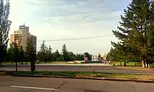
 From top left: Surp Hovhannes Church • Abovyan skyline Friendship Square • Kh. Abovyan's bust General view of Abovyan | |
 Abovyan Աբովյան | |
| Coordinates: 40°16′26″N 44°37′32″E | |
| Country | |
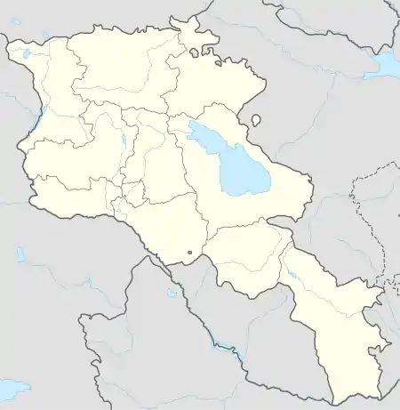
| Marz (province) | Kotayk |
| Founded | 1963 |
| Area | |
| • Total | 11 km2 (4 sq mi) |
| Elevation | 1,450 m (4,760 ft) |
| Population (2011 census) | |
| • Total | 43,495 |
| • Density | 4,000/km2 (10,000/sq mi) |
| Time zone | UTC+4 (UTC) |
| Area code(s) | (+374)222 |
| Website | Official website |
| Sources: Population[1] | |
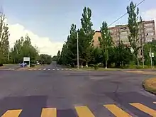
With a motorway and railway running through the city connecting Yerevan with the areas of the northeast, Abovyan is considered a satellite city of the Armenian capital. Therefore, Abovyan is generally known as the "northern gate of Yerevan".
Abovyan covers an area of around 11 square kilometres (4.2 square miles).
Etymology
The present-day Abovyan was occupied by a small village known as Elar. In 1961, the village was renamed Abovyan in honour of the Armenian prominent writer Khachatur Abovian. In 1963, the urban settlement of Abovyan was officially founded.
History
During the excavations of 1960 led by historian Mesrop Smbatiants, the remains of a 2nd-mellennium BC Cyclopean fortress, an ancient cemetery and old shelters with several objects that represent the 3 stages of the Bronze Age were found in the area of Abovyan.[2]
Smbatiants also found an 8th-century BC Urartian cuneiform left by King Argishti I, referring to the conquest of the "land of Darani" (the pre-Urartian name of modern-day Abovyan area).
The excavations led by Smbatiants revealed that the area of modern-day Abovyan was inhabited starting from the end of the 4th century BC.
During the ancient Kingdom of Armenia, the western area of modern-day Abovyan was part of the "Kotayk" canton of Ayrarat province while the eastern area was part of "Mazaz" canton of the same province.
Between the 5th and 7th centuries AD, the region was granted to the Amatuni Armenian noble dynasty.
%252C_Ara_mountain_in_the_background.jpg.webp)
After the Seljuk invasion of Armenia, the area became known as Elar. According to the Armenian historian Stepanos Orbelian of the 13th century, Elar became part of the Kingdom of Georgian. Later, the region of Elar was granted to prince Liparit Orbeli by prince Ivane Mkhargrdzeli.
By the beginning of the 16th century, Eastern Armenia fell under the Persian rule, and Elar became part of the Erivan Beglarbegi and later of the Erivan Khanate. After the Russian conquest of Armenia in 1828, Elar became part of the Armenian Oblast and subsequently of the Erivan Governorate formed in 1850.
The small village of Elar (currently part of Abovyan) remained the largest settlement in the area until 1961, when it was renamed Abovyan in honour of the Armenian writer Khachatur Abovian. 2 years later in 1963, the town of Abovyan was founded by the decision of the Soviet government, including the village of Elar and the surrounding areas.
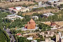
The modern town was built in 1962–1963 on a plateau located between Hrazdan and Azat rivers. It has rapidly developed as an industrial centre within the Armenian SSR. The town was planned to include 8 residential neighbourhoods (locally known as micro-districts), and an industrial district.
Geography and climate
.jpg.webp)
Abovyan is built on Kotayk plateau between the rivers of Hrazdan, Azat and Getar at a height of 1,450 metres (4,760 feet) above sea level. It is surrounded by Gutanasar volcano of Gegham mountains from the north, Mount Hatis from the east, the heights of Nork from the south, Hrazdan gorge from the west and Mount Ara from the northwest. The climate is Humid continental (Köppen: Dfa) and dry with relatively hot summers and cold winters.
| Climate data for Abovyan | |||||||||||||
|---|---|---|---|---|---|---|---|---|---|---|---|---|---|
| Month | Jan | Feb | Mar | Apr | May | Jun | Jul | Aug | Sep | Oct | Nov | Dec | Year |
| Average high °C (°F) | 0.6 (33.1) |
2.0 (35.6) |
7.6 (45.7) |
14.3 (57.7) |
19.5 (67.1) |
24.0 (75.2) |
27.9 (82.2) |
27.6 (81.7) |
23.9 (75.0) |
17.4 (63.3) |
9.8 (49.6) |
3.2 (37.8) |
14.8 (58.7) |
| Daily mean °C (°F) | −4.0 (24.8) |
−2.7 (27.1) |
2.5 (36.5) |
8.4 (47.1) |
13.1 (55.6) |
17.1 (62.8) |
20.8 (69.4) |
20.6 (69.1) |
16.4 (61.5) |
10.8 (51.4) |
4.6 (40.3) |
−1.1 (30.0) |
8.9 (48.0) |
| Average low °C (°F) | −8.5 (16.7) |
−7.3 (18.9) |
−2.6 (27.3) |
2.5 (36.5) |
6.8 (44.2) |
10.3 (50.5) |
13.7 (56.7) |
13.6 (56.5) |
9.0 (48.2) |
4.2 (39.6) |
−0.6 (30.9) |
−5.3 (22.5) |
3.0 (37.4) |
| Average precipitation mm (inches) | 18 (0.7) |
22 (0.9) |
30 (1.2) |
46 (1.8) |
71 (2.8) |
53 (2.1) |
31 (1.2) |
25 (1.0) |
22 (0.9) |
34 (1.3) |
26 (1.0) |
18 (0.7) |
396 (15.6) |
| Source: Climate-Data.org [3] | |||||||||||||
Demographics
Population
More than 90% of the population are ethnic Armenians, mainly from the Armenian diaspora who were relocated from Syria, Iran and Lebanon during the 1960s.
Minor communities of Kurds, Yazidis, Russians and Assyrians are also found in the town.[4]
As of the 2011 census, Abovyan is the 5th-largest city in Armenia in term of population.
Here is the population timeline of Abovyan (note that the figures shown between 1873 and 1959 are related with the population of Elar village, now a neighborhood within Abovyan):
| Year | 1873 | 1897 | 1926 | 1939 | 1959 | 1970 | 1973 | 1976 | 1989 | 2001 | 2011 | 2016 |
|---|---|---|---|---|---|---|---|---|---|---|---|---|
| Population | 360 | 548 | 897 | 1,024 | 2,289 | 14,700 | 28,500 | 38,400 | 58,671 | 44,596 | 43,495 | 35,400 |
The healthcare in the town is served by the Abovyan Medical Centre named after Rubik Harutyunyan, the Abovyan Maternity Hospital, the Republican Anti-Tuberculosis Dispensary, and the Saint Marie Clinic Hospital.
Religion
The majority of the population of Abovyan are Armenians who belong to the Armenian Apostolic Church.
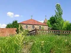
The oldest standing church in the town is the Surp Stepanos church dating back to 1851. It remained closed since the Soviet days until 2010 when it was entirely renovated and reopened for the public on 28 November of the same year.
The other church of the town is the Saint John the Baptist Church opened in 2013 by the efforts of the Armenian businessman Gagik Tsarukyan. The architect of the church is Artak Ghulyan. It is one of the largest places of worship in Armenia.
There is a small Molokan Russian community in the town.
Culture
Abovyan has a cultural palace, a public library and a community creative centre for children and teenagers. The town is also home to a museum opened in 1982 and dedicated to the brotherhood and friendship between the Armenian and Russian nations. The recently renovated theatre of Abovyan has a regular schedule of theatrical shows.
The Abovyan day is celebrated every year in mid October.[5]
The town used to have a cinema theatre during the Soviet days. However, it is currently used as a shopping centre.
Transportation
Being approximately located in northeastern Yerevan, Abovyan is connected with capital city with buses and minibuses that are in service 24 hours a day. The H-1 Road connects Abovyan with Yerevan, while the M-4 Motorway connects the town with the rest of Armenia.
Being a satellite town of the capital Yerevan, Abovyan is connected with the capital city with public vans, locally-known as marshrutka. These vehicles are mainly Russian-made GAZelle vans with 13 seats, having regular trips between the two cities throughout the day.
Economy
Abovyan was founded by the Soviets as an industrial town. It used to have many large industrial firms until the fall of the Soviet Union, including a concrete factory, a stone-processing plant and a chemicals factory. The town has an industrial district located to the south of the town. The sector is quite diversified including several types of finished goods and services, such as building materials, processed food and beverages, pharmaceuticals, and polymer products.
Major firms for building materials production include the Suardi Armenia Factory since 1963, Armstone Plant since 1996, Multi Group Stone since 2002, and Italasphalt Factory since 2015. Alcoholic beverages are also produced by several factories including the Samkon Brandy Factory since 1970, Kotayk Brewery since 1974, and the Ginevan Factory for wine, brandy, beer and canned food, since 2011. The Arpimed Pharmaceutical Enterprise has been operating since 1999, while the Poli-Serv Factory for polymer products has been operating since 2001. Processed-food has been produced by Tamara Factory for dairy products and sweets since 1988, by the Luma Factory for meat products and chips since 1995, by the Sipan Plant for canned food and soft drinks since 2003, and by the Tamara Food Enterprise for convenience food since 2007.
Education
As of 2015, Abovyan has 10 public education schools, 9 kindergartens and 2 state intermediate colleges.
2 major science institutions and research centres are located in Abovyan: the Republican Hospital of tuberculosis, and the Institute of Biological Microbes of the Armenian National Academy of Sciences.
The town has musical academy as well as an arts school.
Sport
FC Kotayk founded in 1955, is one of the oldest football clubs in Armenia who represented Abovyan until 2005. Like many other football clubs in the country, FC Kotayk was forced to default from the Armenian football league and consequently from professional football in 2005, due to financial difficulties.
The short-lived King Delux FC represented the town in a single season of the Armenian First League in 2012–13 before going defunct.
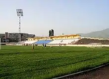
The town is home to the Abovyan City Stadium opened in 1966 with a seating capacity of 3,946, as well as the Gagik Tsaurkyan sports and cultural centre.
Notable people
- Marat Aleksanian, Armenian politician
- Vanes Martirosyan, Armenian-American professional boxer
- Masis Voskanyan, Armenian footballer
International relations
See also
References
| Wikimedia Commons has media related to Abovyan. |
- 2011 Armenia census, Kotayk Province. armstat.am
- Union of Communities of Armenia:Abovyan (Kotayk) Archived January 24, 2011, at WebCite
- "Climate: Abovyan". Climate-Data.org. Retrieved August 15, 2018.
- Abovyan city:Kurdish Community of Abovyan city Archived January 24, 2011, at WebCite
- Abovyan festivals. panorama.am (2015-10-02)
6.Abovyan city: Kurdish community of abovyan 7.Assiryans in Arzni The Social and Cultural News of Abovyan City
Capital: Hrazdan | ||
| Urban communities | 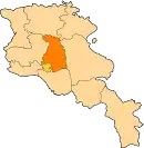 | |
| Rural communities |
| |
| Non-community settlements | ||