Administrative divisions of Poltava Oblast
Poltava Oblast is subdivided into districts (raions) which are subdivided into amalgamated territorial communities (hromadas).
Administrative divisions after 2020
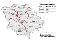
Raions of Poltava Oblast as of August 2020.
On 18 July 2020, the number of districts was reduced to four.[1][2] These are:
- Kremenchuk (Кременчуцький район), the center is in the town of Kremenchuk;
- Lubny (Лубенський район), the center is in the town of Lubny;
- Myrhorod (Миргородський район), the center is in the town of Myrhorod;
- Poltava (Полтавський район), the center is in the city of Poltava.
Administrative divisions until 2020
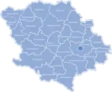
Raions of Poltava Oblast as of June 2020. The city of Poltava is shown in dark blue.
Before 2020, Poltava Oblast was subdivided into 31 regions: 24 districts (raions) and 6 city municipalities (mis'krada or misto), officially known as territories governed by city councils.[3]
- Cities under the oblast's jurisdiction:
- Poltava (Полтава), the administrative center of the oblast
- Hadiach (Гадяч)
- Horishni Plavni (Горішні Плавні), formerly Komsomolsk[4]
- Kremenchuk (Кременчук)
- Lubny (Лубни)
- Myrhorod (Миргород)
- Districts (raions):
- Chornukhy (Чорнухинський район)
- Urban-type settlements under the district's jurisdiction:
- Chornukhy (Чорнухи)
- Urban-type settlements under the district's jurisdiction:
- Chutove (Чутівський район)
- Urban-type settlements under the district's jurisdiction:
- Chutove (Чутове)
- Skorokhodove (Скороходове), formerly Artemivka[4]
- Urban-type settlements under the district's jurisdiction:
- Dykanka (Диканський район)
- Urban-type settlements under the district's jurisdiction:
- Dykanka (Диканька)
- Urban-type settlements under the district's jurisdiction:
- Hadiach (Гадяцький район)
- Hlobyne (Глобинський район)
- Hrebinka (Гребінківський район)
- Cities and towns under the district's jurisdiction:
- Hrebinka (Гребінка)
- Cities and towns under the district's jurisdiction:
- Karlivka (Карлівський район)
- Cities and towns under the district's jurisdiction:
- Karlivka (Карлівка)
- Cities and towns under the district's jurisdiction:
- Khorol (Хорольський район)
- Cities and towns under the district's jurisdiction:
- Khorol (Хорол)
- Cities and towns under the district's jurisdiction:
- Kobeliaky (Кобеляцький район)
- Cities and towns under the district's jurisdiction:
- Kobeliaky (Кобеляки)
- Urban-type settlements under the district's jurisdiction:
- Bilyky (Білики)
- Cities and towns under the district's jurisdiction:
- Kotelva (Котелевський район)
- Urban-type settlements under the district's jurisdiction:
- Kotelva (Котельва)
- Urban-type settlements under the district's jurisdiction:
- Kozelshchyna (Козельщинський район)
- Urban-type settlements under the district's jurisdiction:
- Kozelshchyna (Козельщина)
- Nova Haleshchyna (Нова Галещина)
- Urban-type settlements under the district's jurisdiction:
- Kremenchuk (Кременчуцький район)
- Lokhvitsia (Лохвицький район)
- Cities and towns under the district's jurisdiction:
- Lokhvytsia (Лохвиця)
- Zavodske (Заводське), formerly Chervonozavodske[4]
- Cities and towns under the district's jurisdiction:
- Lubny (Лубенський район)
- Mashivka (Машівський район)
- Urban-type settlements under the district's jurisdiction:
- Mashivka (Машівка)
- Urban-type settlements under the district's jurisdiction:
- Myrhorod (Миргородський район)
- Urban-type settlements under the district's jurisdiction:
- Komyshnia (Комишня)
- Romodan (Ромодан)
- Urban-type settlements under the district's jurisdiction:
- Novi Sanzhary (Новосанжарський район)
- Urban-type settlements under the district's jurisdiction:
- Novi Sanzhary (Нові Санжари)
- Urban-type settlements under the district's jurisdiction:
- Orzhytsia (Оржицький район)
- Urban-type settlements under the district's jurisdiction:
- Novoorzhytske (Новооржицьке)
- Orzhytsia (Оржиця)
- Urban-type settlements under the district's jurisdiction:
- Poltava (Полтавський район)
- Pyriatyn (Пирятинський район)
- Cities and towns under the district's jurisdiction:
- Pyriatyn (Пирятин)
- Cities and towns under the district's jurisdiction:
- Reshetylivka (Решетилівський район)
- Urban-type settlements under the district's jurisdiction:
- Reshetylivka (Решетилівка)
- Urban-type settlements under the district's jurisdiction:
- Semenivka (Семенівський район)
- Urban-type settlements under the district's jurisdiction:
- Semenivka (Семенівка)
- Urban-type settlements under the district's jurisdiction:
- Shyshaky (Шишацький район)
- Urban-type settlements under the district's jurisdiction:
- Shyshaky (Шишаки)
- Urban-type settlements under the district's jurisdiction:
- Velyka Bahachka (Великобагачанський район)
- Urban-type settlements under the district's jurisdiction:
- Hoholeve (Гоголеве)
- Velyka Bahachka (Велика Багачка)
- Urban-type settlements under the district's jurisdiction:
- Zinkiv (Зіньківський район)
- Cities and towns under the district's jurisdiction:
- Zinkiv (Зіньків)
- Urban-type settlements under the district's jurisdiction:
- Opishnia (Опішня)
- Cities and towns under the district's jurisdiction:
- Chornukhy (Чорнухинський район)
References
- "Про утворення та ліквідацію районів. Постанова Верховної Ради України № 807-ІХ". Голос України (in Ukrainian). 2020-07-18. Retrieved 2020-10-03.
- "Нові райони: карти + склад" (in Ukrainian). Міністерство розвитку громад та територій України.
- "Чисельність наявного населення України (Actual population of Ukraine)" (PDF) (in Ukrainian). State Statistics Service of Ukraine. Retrieved 2 September 2020.
- Чисельність наявного населення України (PDF) (in Ukrainian). State Service of Statistics. Archived from the original (PDF) on 22 July 2016. Retrieved 20 July 2016.
| Raions | |||||
|---|---|---|---|---|---|
| Hromadas | |||||
| Cities |
| ||||
| |||||
This article is issued from Wikipedia. The text is licensed under Creative Commons - Attribution - Sharealike. Additional terms may apply for the media files.