Agame
Agame (Ge'ez: ዓጋመ, agamä; "fruitful") is a former province in northern Ethiopia and is now part of the Tigray Region. Agame is located at the northeastern corner of the Ethiopian Empire. It borders on the Eritrean province of Akele Guzai in the north, Tembien, Kalatta Awlalo and Enderta in the south, and both the Eritrean and Ethiopian Afar lowlands in the east. This relative location placed Agame at the strategic cross-roads between the Red Sea Cost and the interior of southern Eritrea, on the one hand, and the northern Tigrayan plateau on the other. In pre-1991, Agame had a total area of about 4,889 square kilometres (1,888 sq mi) with an estimated population of 344,800.[1]
Agame
ዓጋመ | |
|---|---|
Province | |
 | |
 Agame | |
| Coordinates: 13°57′N 39°13′E | |
| Tigray Province | Province |
| Government | |
| • Type | Monarchy |
| • Body | House of Agame |
| Area | |
| • Total | 4,889 km2 (1,888 sq mi) |
| Dimensions | |
| • Length | 139.92 km (86.94 mi) |
| • Width | 66.39 km (41.25 mi) |
| Population | |
| • Total | 344,800 |
| Ethnicity | |
| Languages | |
History
980 BC - 940 AD
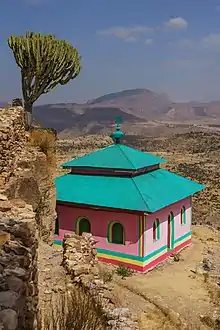
Agame is one of the oldest regions of Ethiopia, being part of the Kingdom of D'mt in northern Ethiopia and Eritrea that would develop into the Kingdom of Aksum. It was a main center of Aksumite culture (second only to Western Tigray, where the capital was located), with a distinct sub-culture that separated the two regions from that of Western Tigray (Shire, Axum, Yeha), Central Eritrea (Seraye, Hamasien, Akele Guzai and Adulis), and frontier areas in northern Eritrea.[2][3] Agame is one of the very few place-names identified in the Adulis inscription as early as the 3rd century.[4][5] It is mentioned there as an apparently viable local political entity and it seems that it continued as such from then onwards. The area also appears to have been part of the eastern cultural province of ancient Aksum: to this period dates back the foundation of the monastery of Debre Damo, which played a major role in Ethiopia's ecclesiastic history throughout the Middle Ages up to the modern times.[1]
11th Century-18th Century
The chiefs of Agame would assume the title of Shum Agame in medieval times and throughout history. Even though in the 16th century the Shum Agame submitted to Ahmad Ibrahim al-Gazi's army, the physical inaccessibility of lowland Agame suited the purpose of providing safe hideouts to various political, religious and social dissidents. It remained the centre of prominent monasteries such as Gunda Gunde Maryam, which was established by the Stephanites during the 15th century. Agame was mentioned in the 16th century charter written during the reign of Emperor Lebna Dengel.[6] During medieval times, Agame was part of a larger province of Bur in Ethiopia, which also included some northeastern Afar lowlands, and the Buri Peninsula; Agame and Akkele Guzay were part of "Upper" (La'ilay) Bur, while the lowlands were further distinguished as "Lower" (Tahtay).[7]
Agame appears on indigenous maps of the northern Horn of Africa in the 15th Century.[8][9]
19th Century
Agame had a major role to play in the political ascendancy of Tigray in Christian Ethiopia during the greater part of the first quarter of the 19th century. One of the prominent warlords of northern Ethiopia, Dejazmatch Sabagadis Woldu, who ruled Tigray in the period 1822-31, had his power base in Agame. His demise at the Battle of Debre Abbay marked a decline in the political importance of Agame in the Tigrayan political arena.[1]
20th Century
In the period 1896-1936, Agame was led by the descendants of Sabagadis. Dejazmatch Kassa Sebhat was the chief of the area during the Italian war 1935-36. He mobilized the people of Agame and engaged the Italians at the battle of Fagena, in the Afar escarpment east of Addigrat. But he was defeated and ultimately surrendered. During 1941-74 Agame existed as an awraja (in the province of Tigray), having five districts (woreda) under it: Gulo Mekeda, Ganta Afshum, Subja Sase, Dallol and Kalatte Balaza. Descendants of the Sabagadis family still governed Agame until the revolution.[1]
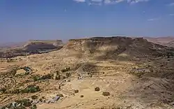
Geography
Agame covered an area that corresponds more or less to the current woredas Ganta Afeshum, Gulomahda, Irob, Hawzen, Sa'isi Tsa'ida Imba; eastbound Agame extended widely into the Danakil lowlands, currently part of the Afar region. Sandstone (Adigrat Sandstone and Enticho Sandstone) are dominant lithologies; hence many soils are sandy. The geomorphology comprises mountain massifs, plains, plateau, deep gorges and river valleys. Archaeological evidence indicates that Agame was one of the earliest places in Ethiopia to adopt ploughshare agriculture, but centuries of over-cultivation and maximum utilization of resource turned the steeper slopes into agriculturally marginal land.[1]
Demographics
The principal inhabitants of Agame are Afar, Saho and Tigrinya-speakers. The Tigrinya-speaking population predominated in the high-lands. The north-eastern and south-eastern sector of the escarpment is principally inhabited by the Saho-speaking Irob and Afar-speakers respectively. Adigrat prevailed as the capital of Agame throughout the 19th and 20th centuries. Since the 19th century, Agame has been an enduring base for Lazarist Catholic evangelization in northern Ethiopia. The legacies of this process are the Catholic Cathedral and the Seminary of Adigrat and the considerable Catholic congregation of Irobland in the lowlands.
Government
The local noble family had ruled over Agame from the "Era of Princes" until the Derg deposed Emperor Haile Selassie in 1974. This family retained sufficient power and respect following the Italian conquest in 1936, that the Italian Viceroy Pietro Badoglio proposed in a telegram to Benito Mussolini that some of the old Ethiopian ruling class be co-opted into Italian East Africa: "In the region between Shoa and Eritrea, there were local noble families which it was not convenient to slight because they had exercised command for generations and have authority and prestige which can be valuable for us."[10]
House of Agame
Ethiopian records traces the origins of this family to the marriage of King Margedir of Rome and Eleni, sister of King Solomon. The current lineage of the rulers of Agame is as follows:
| Shum Agame Kumalit | |||||||||||||||||||||||||||||||||||||||||||||||||||||||||||||||||||||||||||||||
| Shum Agame Woldu Kumalit r.1802-1815 | Woizero Sabana Giyorgis m.1802 | ||||||||||||||||||||||||||||||||||||||||||||||||||||||||||||||||||||||||||||||
| Woizero Desta m.1817 | Dejazmatch Sabagadis Woldu 1770-1831 r.1818-1831 | Fitawrari Gabru Gura | Shum Agame Agus | Shum Agame Sardie | Shum Agame Gabre Medhin | Shum Agame Wolde Tiatos | |||||||||||||||||||||||||||||||||||||||||||||||||||||||||||||||||||||||||
| Dejazmatch Kassa Sabagadis | Dejazmatch Wolde Mikael | Dejazmatch Hagos Sabagadis | Dejazmatch Aregawi Sabagadis r.1831-1859 | Lij Balgada Araya | Lij Hailu | ||||||||||||||||||||||||||||||||||||||||||||||||||||||||||||||||||||||||||
| Dejazmatch Desta Aragawi | Dejazmatch Wolde Gabriel Aragawi | Lij Asgadem Aragawi | Dejazmatch Abbaya Aragawi | Ras Sebhat Aregawi r.1892-1914 | Woizero Shoanesh m.1892 | ||||||||||||||||||||||||||||||||||||||||||||||||||||||||||||||||||||||||||
| Dejazmatch Asgedom Sebhat | Woizero Gereda Sebhat | Woizero Lemlem Sebhat | Woizero Hareya Sebhat | Woizero Semret Sebhat | Shum Agame Desta Sebhat -1914 | Woizero Zenebech Sebhat | Ras Kassa Sebhat r.1914-1974 | Dejazmatch Ayele Sebhat | Lij Gebrezgi Sebhat -1935 | ||||||||||||||||||||||||||||||||||||||||||||||||||||||||||||||||||||||
Traditional food and drinks
Typical traditional food and drinks of Agame are
- tehlo, a dough made from roasted and grided barley, typically rolled in small balls by a beautiful woman in front of the guests, dipped in spicy sauce and eaten with wooden forks
- the honey wine myes, called chianti when strong
- siwa beer
A traditional praising song in Tigrinya contains the wording Agame, addi tehlo, addi ma’ar (Agame land of tehlo and honey), Agame addi Saba (Agame land of Queen Sheba), ...
References
- "Agamä". Encyclopedia Aethiopica. 1. Wiesbaden: Harrassowitz Verlag. 2003. p. 137.
- Stuart Munro-Hay, Aksum: An African Civilization of Late Antiquity. Edinburgh: University Press, 1991. Online version (pdf), pp. 36-37.
- Rodolfo Fattovich, "Some Data for the study of Cultural History in Ancient Northern Ethiopia", Nyame Akuma, Newsletter of the Society of Africanist Archaeologists in America, May 1977, pp. 6-18.
- L. P. Kirwan, "The Christian Topography and the Kingdom of Axum", Geographical Journal, 1972, pp. 172-3
- Munro-Hay, Aksum, pp. 186-7.
- G.W.B. Huntingford, The historical geography of Ethiopia from the first century AD to 1704, (Oxford University Press: 1989), p. 99
- "Bur" in Uhlig, Siegbert, ed. Encyclopaedia Aethiopica: A-C. Wiesbaden: Otto Harrassowitz KG, 2003.
- Nyssen, J., Tesfaalem Ghebreyohannes, Hailemariam Meaza, Dondeyne, S., 2020. Exploration of a medieval African map (Aksum, Ethiopia) – How do historical maps fit with topography? In: De Ryck, M., Nyssen, J., Van Acker, K., Van Roy, W., Liber Amicorum: Philippe De Maeyer In Kaart. Wachtebeke (Belgium): University Press: 165-178.
- Smidt W (2003) Cartography, in: Uhlig S (ed.): Encyclopaedia Aethiopica, Wiesbaden: Harrassowitz, vol. 1: 688-691
- Richard P.K. Pankhurst, "The Secret History of the Italian Fascist Occupation of Ethiopia, 1935-1941, 2"