Aguada, Santander
Aguada (Spanish pronunciation: [aˈɣwaða]) is a town and municipality in the Vélez Province of the Santander Department in northeastern Colombia. Aguada is located in the vicinity of the Opón River at an altitude of 1,700 metres (5,600 ft). It borders El Guacamayo in the north, San Benito in the south, Suaita in the east and La Paz in the west.[1]
Aguada | |
|---|---|
Municipality and town | |
.svg.png.webp) Flag  Seal | |
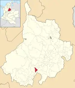 Location of the municipality and town of Aguada in the Santander Department of Colombia | |
| Country | |
| Department | Santander Department |
| Province | Vélez Province |
| Founded | 1956 |
| Government | |
| • Mayor | Ramiro Javier Ariza Almanzar (2016-2019) |
| Area | |
| • Municipality and town | 75.75 km2 (29.25 sq mi) |
| • Urban | 0.04 km2 (0.02 sq mi) |
| Elevation | 1,700 m (5,600 ft) |
| Population (2015) | |
| • Municipality and town | 1,855 |
| • Density | 24/km2 (63/sq mi) |
| • Urban | 225 |
| Time zone | UTC-5 (Colombia Standard Time) |
| Climate | Cfb |
| Website | Official website |
History
The area of Aguada before the Spanish conquest was inhabited by the Yarigui people. In early 1537, the difficult expedition into the heart of Colombia led by Gonzalo Jiménez de Quesada passed through Aguada.[1]
Modern Aguada was founded in 1956.[1]
Economy
Main source of income of Aguada is agriculture with products panela reed, maize, beans, yuca, coffee, peas and arracacha cultivated.[1]
References
- (in Spanish) Official website Aguada
This article is issued from Wikipedia. The text is licensed under Creative Commons - Attribution - Sharealike. Additional terms may apply for the media files.
