Aird Uig
Aird Uig (Scottish Gaelic: Àird Ùig) is a village on the Isle of Lewis, in the Outer Hebrides, Scotland. Aird Uig is within the parish of Uig,[1] and is situated on the C40 minor road which joins to the B8011 at Timsgarry.[2]
Aird Uig
| |
|---|---|
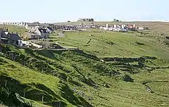 Buildings at Aird Uig | |
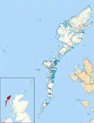 Aird Uig Location within the Outer Hebrides | |
| Language | Scottish Gaelic English |
| OS grid reference | NB048379 |
| Civil parish | |
| Council area | |
| Lieutenancy area | |
| Country | Scotland |
| Sovereign state | United Kingdom |
| Post town | ISLE OF LEWIS |
| Postcode district | HS2 |
| Dialling code | 01851 |
| Police | Scotland |
| Fire | Scottish |
| Ambulance | Scottish |
| UK Parliament | |
| Scottish Parliament | |
Aird Uig is a village of two distinctive characters. The south end is composed of a traditional crofting community whilst the north end is a composite of army barracks and buildings many of which have been converted into homes. Aird Uig village is home to a diverse and active community. It is situated near a bay that leads north to the Gallan Head Peninsula and has extensive views of the surrounding seascape.
Between 1954 and 2010, the Royal Air Force (and latterly, NATO), operated a RADAR site at Gallan Head called RAF Aird Uig. The community is now trying to open the former base to the public as an observatory, gallery and whale listening post.[3]
References
- "Details of Aird Uig". Scottish Places. Retrieved 29 December 2014.
- "Ice Gritting 2013/14 List of Road Priorities" (PDF). Comhairle nan Eilean Siar. Archived from the original (PDF) on 30 January 2016. Retrieved 29 December 2014.
- "Letter to MoD over Aird Uig clean-up". The Stornoway Gazette. 24 August 2015. Retrieved 17 August 2017.
External links
| Wikimedia Commons has media related to Aird Uig. |
- Canmore - Lewis, Aird Uig site record
- Canmore - Garadh Steishal, Aird, Uig, Lewis site record
- Canmore - Aird Uig, Prehistoric Cairn site record
- Canmore - Lewis, Aird Uig, Rotor Radar Site site record
- Canmore - Lewis, Aird Uig, Rotor Radar Site site record
