Al-Ahsa Oasis
Al-Aḥsāʾ (Arabic: الْأَحْسَاء, al-ʾAhasā), also known as al-Ḥasāʾ (الْحَسَاء) or Hajar (هَجَر), is a traditional oasis historical region in eastern Saudi Arabia whose name is used by the Al-Ahsa Governorate, which makes up much of that country's Eastern Province. The oasis is located about 60 km (37 mi) inland from the coast of the Persian gulf.
| UNESCO World Heritage Site | |
|---|---|
 | |
| Location | Hofuf, Al-Ahsa Governorate, Saudi Arabia |
| Criteria | Cultural: (iii), (iv), (v) |
| Reference | 1563 |
| Inscription | 2018 (42nd session) |
| Area | 8,544 ha |
| Buffer zone | 21,556 ha |
| Coordinates | 25°25′46″N 49°37′19″E |
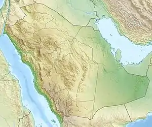 Location of Al-Ahsa Oasis in Saudi Arabia | |
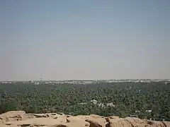
With an area of around 85.4 km2 (33.0 sq mi), Al-Ahsa Oasis is the largest oasis in the world. There are more than 2.5 million palm trees including date palms in the oasis, which is fed from a huge underground aquifer and irrigated by the flow of more than 280 artesian springs, which allows agriculture all year round in a region that is otherwise sand desert.[1]
Al-Ahsa is part of the region known historically for its high skill in tailoring, especially in making bisht, a traditional men's cloak.[2] Al-Bahrain geographical province is in Eastern Arabia, which includes the eastern coast of the Arabian Peninsula down to the borders of the UAE, Oman, and also includes the island of Awal (modern-day Bahrain). Historically, Al-Ahsa was the main city in Al-Bahrain province, making up most of its population and providing most of its agricultural output.
The site has become a World Heritage site in 2018.[3] It has also been part of UNESCO Creative Cities Network since December 2015.[4] According to one author, the oases of Al-Hasa and Al Ain (in the UAE, on the border with Oman) are the most important in the Arabian Peninsula.[5]
Etymology
Al-Ahsa is a plural word of "Al-Ḥisā" (Arabic: ٱلْحِسَى) which refers to the accumulated sand with an impermeable layer underneath. Thus, when rain comes down, the water will soak through the sand, protected from evaporation by the sand, and be retained by the base layer, forming an aquifer. Hence, the site would become when drilled like a sweet cold spring.[6]
History
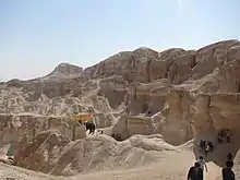
.jpg.webp)
Ancient history
Al-Ahsa has been inhabited since prehistoric times, due to its abundance of water in an otherwise arid region.[7] Natural fresh-water springs have surfaced at oases in the region for millennia, encouraging human habitation and agricultural efforts (date palm cultivation especially) since prehistoric times.
The oasis region and the name Hajar (also Hagar, Haǧar) specifically may be related to the Ancient Near East toponym Agarum, mentioned in Dilmunite inscriptions as the original home of their chief deity Inzak. If so, Agarum probably referred to the mainland Arabia opposite of Bahrain.[8] According to the hypothesis, the Dilmun civilization originated at the oases of Eastern Arabia, but later relocated to the isle of Bahrain. This interpretation is not without criticism, however, and other sources place Agarum on the isle of Failaka.[9]
Islamic times
Eastern Arabia was conquered by the emerging Rashidun Caliphate during the 7th century. It was later inherited by the Umayyads and Abbasids. In 899 A.D., the region came under the control of the Qarmatian leader, Abu Tahir al-Jannabi,[10] and was declared independent from the Abbasid Caliphate of Baghdad. Its capital was at al-Mu'miniya near modern Hofuf. By circa 1000, Al-Hasa became the 9th largest city worldwide supporting 100,000 inhabitants.[11] In 1077, the Qarmatian state of Al-Ahsa was overthrown by the Uyunids. Al-Ahsa subsequently fell under the rule of the Bahrani dynasty of the Usfurids, followed by their relatives, the Jabrids, who became one of the most formidable powers in the region, retaking the islands of Bahrain from the princes of Hormuz. The last Jabrid ruler of Bahrain was Muqrin ibn Zamil.
In 1521, the Portuguese Empire conquered the Awal Islands (the islands that comprise present day Bahrain) from the Jabrid ruler Muqrin ibn Zamil, who fell strongly in battle.[12] The Jabrids struggled to maintain their position on the mainland in the face of the Ottomans and their tribal allies, the Muntafiq. In 1550, Al-Ahsa and nearby Qatif came under the sovereignty of the Ottoman Empire with Sultan Suleiman I.[13] Al-Ahsa was nominally the Eyalet of Lahsa in the Ottoman administrative system, and was usually a vassal of the Porte. Qatif was later lost to the Portuguese.
The Ottomans were expelled from Al-Ahsa in 1670,[13] and the region came under the rule of the chiefs of Banu Khalid tribe.
Al-Ahsa, along with Qatif, was incorporated into the Wahhabist Emirate of Diriyah in 1795, but returned to Ottoman control in 1818 with an invasion ordered by Muhammad Ali of Egypt. The Banu Khalid were again installed as rulers of the region but, in 1830, the Emirate of Nejd retook the region.
Direct Ottoman rule was restored in 1871,[13] and Al-Ahsa was placed first under Baghdad Vilayet and with Baghdad's subdivision Basra Vilayet in 1875. In 1913, ibn Saud, the founder of modern Saudi Arabia, annexed Al-Ahsa and Qatif into his domain of Najd.[14]
Saudi independence
On 2 December 1922, Percy Cox officially notified Kuwait's Emir Sheikh Ahmad Al-Sabah that Kuwait's borders had been modified.[15] Earlier that year, Major John More, the British representative in Kuwait, had met with Ibn Saud of Saudi Arabia to settle the border issue between Kuwait and Najd. The result of the meeting was the Uqair Protocol of 1922, in which Britain recognized ibn Saud's sovereignty over territories claimed by the emir of Kuwait.
Al-Ahsa was taken from the Ottomans in 1913,[16] bringing the Al Sauds control of the Persian Gulf coast and what would become Saudi Arabia's vast oil reserves.
Economy
Historically, Al-Hasa was one of the few areas in Arabian Peninsula growing rice.[17] In 1938, petroleum deposits were discovered near Dammam,[18][19] resulting in the rapid modernization of the region. By the early 1960s, production levels reached 1 million barrels (160,000 m3) per day. Today, Al-Hasa engulfs the largest conventional oil field in the world, the Ghawar Field.
Al-Hasa is known for its palm trees and date palms. Al-Hasa has over 2.5 million palm trees which produce over 100 thousand tons of dates every year.
Tourist sites
- Springs
The number of springs and freshwater sources in Al-Hasa oasis range from 60 to 70 like those in Ummsaba'ah, Al-Harrah and Al-Khadod.
- Antiquities
Al-Hasa oasis filled with a number of archaeological sites that give witness to the area's importance.
- Landmarks
12 locations were defined as the Cultural Landscape of Al-Hasa Oasis (the World Heritage site):[3]
- Eastern Oasis (الواحة الشرقية)
- Northern Oasis (الواحة الشمالية)
- As-Seef (السِيف)
- Suq Al-Qaysariyah (سوق القيصرية)
- Qasr Khuzam (قصر خزام)
- Qasr Sahood (قصر صاهود)
- Qasr Ibrahim (قصر ابراهيم)
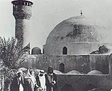
- Jawatha archaeological site (موقع جواثا الأثري)
- Jawatha Mosque (مسجد جواثا)
- Al-'Oyun village (قرية العيون)
- Ain Qannas archaeological site (موقع عين قناص الأثري)
- Al-Asfar lake (بحيرة الأصفر)
Climate
Al-Ahsa has a hot desert climate (Köppen Climate Classification: BWh), with long, extremely hot summers and short, very mild winters. The oasis has a very low annual precipitation of 83.3 mm (3.28 in), but receives a little amount of rain in winter and spring.
| Climate data for Al Ahsa (1985–2010) | |||||||||||||
|---|---|---|---|---|---|---|---|---|---|---|---|---|---|
| Month | Jan | Feb | Mar | Apr | May | Jun | Jul | Aug | Sep | Oct | Nov | Dec | Year |
| Record high °C (°F) | 32.7 (90.9) |
37.8 (100.0) |
41.2 (106.2) |
45.0 (113.0) |
49.0 (120.2) |
50.6 (123.1) |
50.8 (123.4) |
49.7 (121.5) |
48.0 (118.4) |
45.6 (114.1) |
45.8 (114.4) |
32.5 (90.5) |
50.8 (123.4) |
| Average high °C (°F) | 21.2 (70.2) |
24.2 (75.6) |
28.9 (84.0) |
35.1 (95.2) |
41.5 (106.7) |
44.4 (111.9) |
45.7 (114.3) |
45.4 (113.7) |
42.3 (108.1) |
37.6 (99.7) |
29.9 (85.8) |
23.4 (74.1) |
35.0 (95.0) |
| Daily mean °C (°F) | 14.7 (58.5) |
17.2 (63.0) |
21.5 (70.7) |
27.2 (81.0) |
33.3 (91.9) |
36.3 (97.3) |
37.8 (100.0) |
37.2 (99.0) |
33.8 (92.8) |
29.2 (84.6) |
22.4 (72.3) |
16.6 (61.9) |
27.3 (81.1) |
| Average low °C (°F) | 8.5 (47.3) |
10.6 (51.1) |
14.3 (57.7) |
19.6 (67.3) |
24.9 (76.8) |
27.6 (81.7) |
29.4 (84.9) |
28.9 (84.0) |
25.3 (77.5) |
21.1 (70.0) |
15.6 (60.1) |
10.5 (50.9) |
19.7 (67.5) |
| Record low °C (°F) | −2.3 (27.9) |
1.0 (33.8) |
0.7 (33.3) |
7.3 (45.1) |
17.0 (62.6) |
18.3 (64.9) |
19.8 (67.6) |
19.7 (67.5) |
17.3 (63.1) |
13.0 (55.4) |
5.8 (42.4) |
0.8 (33.4) |
−2.3 (27.9) |
| Average rainfall mm (inches) | 15.0 (0.59) |
11.6 (0.46) |
16.2 (0.64) |
10.7 (0.42) |
2.1 (0.08) |
0.0 (0.0) |
0.0 (0.0) |
0.9 (0.04) |
0.0 (0.0) |
0.6 (0.02) |
5.1 (0.20) |
21.1 (0.83) |
83.3 (3.28) |
| Average precipitation days | 8.7 | 5.8 | 9.1 | 7.3 | 2.0 | 0.0 | 0.1 | 0.2 | 0.0 | 0.3 | 3.1 | 7.2 | 43.8 |
| Average relative humidity (%) | 55 | 49 | 44 | 38 | 27 | 22 | 23 | 30 | 33 | 39 | 47 | 56 | 39 |
| Source: Jeddah Regional Climate Center[22] | |||||||||||||
See also
- List of World Heritage sites in Saudi Arabia
References
- "Largest oasis". Guinness World Records.
- Rima Al Mukhtar (9 November 2012). "Traditional & modern: The Saudi man's bisht". Arab News. Retrieved 12 July 2018.
- "Al-Ahsa Oasis, an evolving Cultural Landscape". UNESCO.
- "Al-Ahsa enters UNESCO Creative Cities Network". Arab News. 13 December 2015. Retrieved 3 October 2018.
- Marshall Cavendish (2007). "Geography and climate". World and Its Peoples. 1. Cavendish Square Publishing. pp. 8–19. ISBN 978-0-7614-7571-2.
- "تعريف و معنى الاحساء في معجم المعاني الجامع - معجم عربي عربي". almaany.com (in Arabic).
- "About". Archived from the original on 23 August 2016. Retrieved 16 June 2013.
- Khaled al-Nashef: "The Deities of Dilmun" (pp. 340–342, 346, 349), in Bahrain Through the Ages: The Archaeology, edited by Scheich ʿAbdāllah Bahrain, Haya Ali Khalifa, Shaikha Haya Ali Al Khalifa & Michael Rice. Routledge, 1986. ISBN 9780710301123.
- Steffen Terp Laursen: Royal Mounds of A'ali in Bahrain: The Emergence of Kingship in Early Dilmun (pp. 430-433). ISD LLC, 2017. ISBN 9788793423190.
- Paul Wheatley (2001). The Places Where Men Pray Together: Cities in Islamic Lands, Seventh Through the Tenth Centuries. University of Chicago Press. p. 129. ISBN 978-0-226-89428-7.
- Al Hasa population soared to 100,000 by circa 1000
- Al-Juhany, Uwidah Metaireek (2002). Najd before the Salafi reform movement: social, political and religious conditions during the three centuries preceding the rise of the Saudi state. London: Ithaca Press. p. 53. ISBN 0-86372-401-9.
- David Long (2005). Culture and Customs of Saudi Arabia (Culture and Customs of the Middle East). Westport, Conn: Greenwood Press. p. xiv, p8. ISBN 0-313-32021-7.
- World and its peoples. London: Marshall Cavendish. 2006. p. 29. ISBN 0-7614-7571-0.
- David Finnie (31 December 1992). Shifting Lines in the Sand. I B Tauris. p. 60. ISBN 1-85043-570-7.
- Mohamed Zayyan Aljazairi (1968). "Diplomatic history of Saudi Arabia, 1903-1960's" (PDF). University of Arizona. p. 26. Retrieved 29 November 2020.
- Prothero, G.W. (1920). Arabia. London: H.M. Stationery Office. p. 85.
- Nathan J. Citino (2002). From Arab nationalism to OPEC: Eisenhower, King Saʻūd, and the making of U. S.-Saudi relations. Bloomington: Indiana University Press. p. xviii. ISBN 0-253-34095-0.
- Fouad Farsy (1986). Saudi Arabia: a case study in development. London: KPI. p. 44. ISBN 0-7103-0128-6.
Dammam petroleum.
- "Qasr Ibrahim", Wikipedia, 26 October 2019, retrieved 26 October 2019
- M. Cetin (2010). "Cultural versus material: conservation issues regarding earth architecture in Saudi Arabia: the case of an Ottoman fort, Ibrahim Palace in Al-Houfuf". International Journal of Civil & Environmental Engineering. 10 (4): 8–14.
- "Climate Data for Saudi Arabia". Jeddah Regional Climate Center. Archived from the original on 12 May 2012. Retrieved 26 January 2016.
External links
- Tor Eigeland, 1970, The Twice-Used Water, Saudi Aramco World
- Jon Mandaville, 1974, Al-Hasa: Outpost of Empire, Saudi Aramco World
- Al-Ahsa municipality website
|