Alabama State Route 125
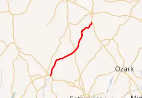
State Route 125 (SR 125) is a 24.72-mile-long (39.78 km) state highway in Coffee and Pike counties in the southeastern part of the U.S. state of Alabama. The southern terminus of the highway is at U.S. Route 84 (US 84) and SR 87 in Elba. The northern terminus of the route is at an intersection with US 231 south of Brundidge.
| ||||
|---|---|---|---|---|
| ||||
| Route information | ||||
| Maintained by ALDOT | ||||
| Length | 24.720 mi[1] (39.783 km) | |||
| Major junctions | ||||
| South end | ||||
| North end | ||||
| Location | ||||
| Counties | Coffee, Pike | |||
| Highway system | ||||
| ||||

Route description
SR 125 begins at US 84/SR 87 (also unsigned SR 12) in Elba, northeast of the downtown area of the city. Heading northeast, SR 125 travels through Victoria and intersects SR 167. It continues to the northeast and then reaches its northern terminus, an intersection with US 231 (internally designated as SR 53) south of Brundidge.[2]
Major intersections
| County | Location | mi[1] | km | Destinations | Notes |
|---|---|---|---|---|---|
| Coffee | Elba | 0.000 | 0.000 | Southern terminus | |
| | 12.637 | 20.337 | |||
| Pike | | 24.720 | 39.783 | Northern terminus | |
| 1.000 mi = 1.609 km; 1.000 km = 0.621 mi | |||||
See also
 U.S. roads portal
 United States portal
References
- Alabama Department of Transportation. "Milepost Maps". Retrieved December 14, 2019.
- Google (December 14, 2019). "Alabama State Route 125" (Map). Google Maps. Google. Retrieved December 14, 2019.
External links
This article is issued from Wikipedia. The text is licensed under Creative Commons - Attribution - Sharealike. Additional terms may apply for the media files.