Alamosa East, Colorado
Alamosa East is an unincorporated community and a census-designated place (CDP) located in Alamosa County, Colorado, United States. The population of the Alamosa East CDP was 1,458 at the United States Census 2010.[4] Alamosa County governs the unincorporated community. The Alamosa post office (Zip code 81101) serves the area.[3]
Alamosa East, Colorado | |
|---|---|
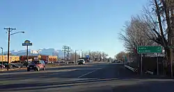 Looking east along U.S. Route 160 (Santa Fe Avenue) in Alamosa East. | |
 Location of the Alamosa East CDP in Alamosa County, Colorado | |
 Alamosa East Location of the Alamosa East CDP in the United States. | |
| Coordinates: 37°28′36″N 105°50′23″W[1] | |
| Country | |
| State | |
| County | Alamosa County |
| Government | |
| • Type | unincorporated community |
| Area | |
| • Total | 3.249 sq mi (8.414 km2) |
| • Land | 3.249 sq mi (8.414 km2) |
| • Water | 0.000 sq mi (0.000 km2) |
| Elevation | 7,536 ft (2,297 m) |
| Population (2010) | |
| • Total | 1,458 |
| • Density | 449/sq mi (173/km2) |
| Time zone | UTC-7 (MST) |
| • Summer (DST) | UTC-6 (MDT) |
| ZIP Code[3] | Alamosa 81101 |
| Area code(s) | 719 |
| GNIS feature[2] | Alamosa East CDP |
Geography
The Alamosa East CDP has an area of 2,079 acres (8.414 km2), all land.[1]
Demographics
The United States Census Bureau initially defined the Alamosa East CDP for the 1970 United States Census.
| Year | Pop. | ±% |
|---|---|---|
| 1970 | 1,040 | — |
| 1980 | 1,175 | +13.0% |
| 1990 | 1,389 | +18.2% |
| 2000 | 1,528 | +10.0% |
| 2010 | 1,458 | −4.6% |
| 2020 | — | |
| Source: United States Census Bureau | ||
See also
- Outline of Colorado
- State of Colorado
- Colorado cities and towns
- Colorado counties
- Great Sand Dunes National Park and Preserve
- Mount Blanca
- San Luis Valley
References
- "State of Colorado Census Designated Places - BAS20 - Data as of January 1, 2020". United States Census Bureau. Retrieved December 2, 2020.
- "U.S. Board on Geographic Names: Domestic Names". United States Geological Survey. Retrieved December 2, 2020.
- "Zip Code 81101 Map and Profile". zipdatamaps.com. 2020. Retrieved December 20, 2020.
- "2010: DEC Summary File 1". United States Census Bureau. Retrieved December 20, 2020.
External links
- Alamosa @ Colorado.com
- Alamosa @ UncoverColorado.com
- Alamosa Convention & Visitors Bureau
- Alamosa County website
Municipalities and communities of Alamosa County, Colorado, United States | ||
|---|---|---|
| City | 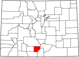 Map of Colorado highlighting Alamosa County | |
| Town | ||
| CDP | ||
| Unincorporated communities | ||
| Footnotes | ‡This populated place also has portions in an adjacent county or counties | |
| ||
This article is issued from Wikipedia. The text is licensed under Creative Commons - Attribution - Sharealike. Additional terms may apply for the media files.
