Albert, Kansas
Albert is a city in Barton County, Kansas, United States. As of the 2010 census, the city population was 175.[6]
Albert, Kansas | |
|---|---|
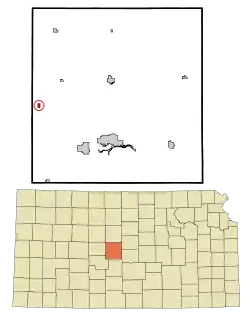 Location within Barton County and Kansas | |
 KDOT map of Barton County (legend) | |
| Coordinates: 38°27′11″N 99°0′45″W | |
| Country | United States |
| State | Kansas |
| County | Barton |
| Founded | 1880s |
| Incorporated | 1929 |
| Named for | Albert Kriesinger |
| Area | |
| • Total | 0.23 sq mi (0.61 km2) |
| • Land | 0.23 sq mi (0.61 km2) |
| • Water | 0.00 sq mi (0.00 km2) |
| Elevation | 1,916 ft (584 m) |
| Population | |
| • Total | 175 |
| • Estimate (2019)[3] | 164 |
| • Density | 697.87/sq mi (268.91/km2) |
| Time zone | UTC-6 (CST) |
| • Summer (DST) | UTC-5 (CDT) |
| ZIP code | 67511 |
| Area code | 620 |
| FIPS code | 20-00825 [4] |
| GNIS ID | 0475626 [5] |
History
Albert was founded in about the early 1880s.[7] It was named for Albert Kriesinger, a storekeeper.[8] Albert was a station on the Great Bend and Scott division of the Atchison, Topeka and Santa Fe Railway.[9]
Geography
Albert is located at 38°27′11″N 99°0′45″W (38.453153, -99.012461).[10] According to the United States Census Bureau, the city has a total area of 0.24 square miles (0.62 km2), all of it land.[11]
Demographics
| Historical population | |||
|---|---|---|---|
| Census | Pop. | %± | |
| 1930 | 183 | — | |
| 1940 | 174 | −4.9% | |
| 1950 | 218 | 25.3% | |
| 1960 | 221 | 1.4% | |
| 1970 | 235 | 6.3% | |
| 1980 | 236 | 0.4% | |
| 1990 | 229 | −3.0% | |
| 2000 | 181 | −21.0% | |
| 2010 | 175 | −3.3% | |
| 2019 (est.) | 164 | [3] | −6.3% |
| U.S. Decennial Census | |||
2010 census
As of the census[2] of 2010, there were 175 people, 77 households, and 58 families living in the city. The population density was 729.2 inhabitants per square mile (281.5/km2). There were 84 housing units at an average density of 350.0 per square mile (135.1/km2). The racial makeup of the city was 96.6% White, 0.6% Native American, 1.7% from other races, and 1.1% from two or more races. Hispanic or Latino of any race were 4.6% of the population.
There were 77 households, of which 24.7% had children under the age of 18 living with them, 59.7% were married couples living together, 14.3% had a female householder with no husband present, 1.3% had a male householder with no wife present, and 24.7% were non-families. 20.8% of all households were made up of individuals, and 10.4% had someone living alone who was 65 years of age or older. The average household size was 2.27 and the average family size was 2.62.
The median age in the city was 46.8 years. 21.1% of residents were under the age of 18; 6.3% were between the ages of 18 and 24; 18.9% were from 25 to 44; 34.2% were from 45 to 64; and 19.4% were 65 years of age or older. The gender makeup of the city was 46.3% male and 53.7% female.
2000 census
As of the census[4] of 2000, there were 181 people, 76 households, and 54 families living in the city. The population density was 762.4 people per square mile (291.2/km2). There were 87 housing units at an average density of 366.5 per square mile (140.0/km2). The racial makeup of the city was 98.34% White, 0.55% from other races, and 1.10% from two or more races. Hispanic or Latino of any race were 2.21% of the population.
There were 76 households, out of which 27.6% had children under the age of 18 living with them, 63.2% were married couples living together, 5.3% had a female householder with no husband present, and 28.9% were non-families. 28.9% of all households were made up of individuals, and 15.8% had someone living alone who was 65 years of age or older. The average household size was 2.38 and the average family size was 2.91.
In the city, the population was spread out, with 26.5% under the age of 18, 5.0% from 18 to 24, 19.3% from 25 to 44, 30.4% from 45 to 64, and 18.8% who were 65 years of age or older. The median age was 44 years. For every 100 females, there were 94.6 males. For every 100 females age 18 and over, there were 90.0 males.
The median income for a household in the city was $39,375, and the median income for a family was $44,792. Males had a median income of $30,250 versus $22,083 for females. The per capita income for the city was $15,948. About 6.8% of families and 4.1% of the population were below the poverty line, including 3.8% of those under the age of eighteen and none of those 65 or over.
References
- "2019 U.S. Gazetteer Files". United States Census Bureau. Retrieved July 24, 2020.
- "U.S. Census website". United States Census Bureau. Retrieved 2012-07-06.
- "Population and Housing Unit Estimates". United States Census Bureau. May 24, 2020. Retrieved May 27, 2020.
- "U.S. Census website". United States Census Bureau. Retrieved 2008-01-31.
- "US Board on Geographic Names". United States Geological Survey. 2007-10-25. Retrieved 2008-01-31.
- "2010 City Population and Housing Occupancy Status". U.S. Census Bureau. Retrieved September 21, 2011.
- Biographical History of Barton County, Kansas. Great Bend Tribune. 1912. pp. 79.
- "Profile for Albert, Kansas". ePodunk. Archived from the original on 1 January 2017. Retrieved 4 June 2014.
- Blackmar, Frank Wilson (1912). Kansas: A Cyclopedia of State History, Embracing Events, Institutions, Industries, Counties, Cities, Towns, Prominent Persons, Etc. Standard Publishing Company. pp. 56.
- "US Gazetteer files: 2010, 2000, and 1990". United States Census Bureau. 2011-02-12. Retrieved 2011-04-23.
- "US Gazetteer files 2010". United States Census Bureau. Archived from the original on 2012-01-25. Retrieved 2012-07-06.
Further reading
External links
- City
- Schools
- USD 403, local school district
- Maps
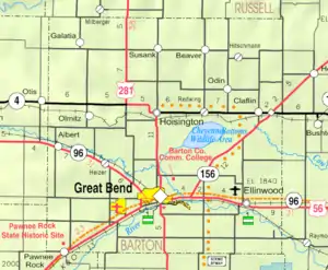
- Albert City Map, KDOT
Municipalities and communities of Barton County, Kansas, United States | ||
|---|---|---|
| Cities | 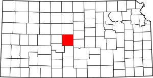 Map of Kansas highlighting Barton County | |
| Unincorporated communities | ||
| Townships | ||
| Footnotes | †This populated place is designated a Census-Designated Place (CDP) by the United States Census Bureau, ‡This populated place also has portions in an adjacent county or counties. | |
| ||