Algeria–Tunisia border
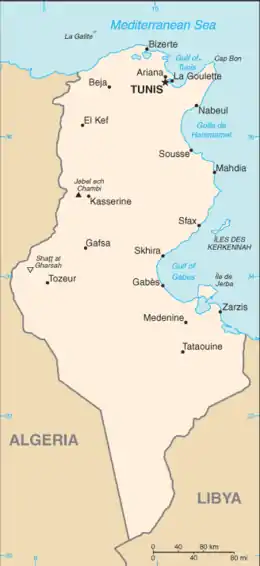
The Algeria–Tunisia border is 1,034 km (642 m) in length and runs from the Mediterranean Sea in the north to the tripoint with Libya in the south.[1]

Description
The border starts in the north at the Mediterranean coast, proceeding overland in a broadly southwards directions via a series of overland lines. In the southern sections of the border straight lines predominate, which eventually veer to the south-east down to the tripoint with Libya.[2]
History
France occupied much of the northern coastal areas of Algeria in the period 1830-47 and Tunisia in 1881, both of which had hitherto been subject to the nominal control of the Ottoman Empire.[3][2] France gradually pushed inland, annexing the Saharan areas of Algeria in 1902.[2] The border from the coast south to Bir Ramane was established by various French decrees, notably those of 1888-89 and 1901-01.[2] The sections south of this down to the Libyan tripoint was somewhat vaguer, and appear to have been delimited during the period 1911-23.[2]
Tunisia gained independence from France in 1956, followed by Algeria (following a bloody war) in 1962. The two states then confirmed the existing boundary between them by an agreement of 6 January 1960, with relations generally being positive.[2][4]
Settlements near the border
Algeria
Tunisia
- Tabarka
- Ain Draham
- Ghardimaou
- Hennchir Abid
- Sakiet Sidi Youssef
- Charpin Ville
- Haïdra
- Ain Amara
- Dernaia
- Moularès
- Tamerza
See also
References
- CIA World Factbook – Algeria, retrieved 22 January 2020
- Brownlie, Ian (1979). African Boundaries: A Legal and Diplomatic Encyclopedia. Institute for International Affairs, Hurst and Co. pp. 89–97.
- M. Şükrü Hanioğlu, A Brief History of the Late Ottoman Empire (Princeton University Press, 2008), 9–10 and 69.
- Entelis, John P. with Lisa Arone. "The Maghrib". Algeria: a country study Archived January 15, 2013, at the Wayback Machine. Library of Congress Federal Research Division (December 1993)